Provide your details below to request scholarly review comments.
×
Verified Request System ®
Order Article Reprints
Please fill in the form below to order high-quality article reprints.
×
Scholarly Reprints Division ®
− Abstract
This study examines the Russia–Ukraine war through a geopolitical and spatial lens to understand its impact on conflict intensity, infrastructure damage, population displacement, and regional economic transformation. Using a spatial analysis approach based on secondary data, the research identifies significant temporal fluctuations in conflict intensity, with peak escalation observed in mid-2022 followed by intermittent variations over time. The spatial distribution of infrastructure damage reveals a highly uneven pattern, with eastern regions of Ukraine such as Donetsk and Luhansk experiencing the most severe destruction, while central and western regions remain comparatively less affected. The study further highlights large-scale population displacement, both internal and cross-border, with migration flows directed toward safer regions and neighboring countries along identifiable corridors influenced by security and accessibility factors. In addition, the findings indicate substantial economic restructuring, where conflict-affected regions experience industrial decline while relatively stable regions witness adaptive economic activity. Overall, the results demonstrate that the Russia–Ukraine war has led to profound spatial and regional transformation, reshaping demographic, economic, and geopolitical structures. The study emphasizes that integrating spatial analysis with geopolitical interpretation provides deeper insight into modern conflicts and their broader regional consequences.
− Explore Digital Article Text
Geopolitical conflicts have become a defining feature of the contemporary world, significantly influencing regional and global dynamics. These conflicts not only reshape political boundaries but also have profound impacts on geographical patterns, including land use, environmental conditions, population distribution, and economic systems. In recent decades, the increasing frequency and intensity of armed conflicts have raised concerns about their long-term implications for regional stability and sustainable development.
The relationship between conflict and geography is complex and multidimensional. Conflicts often lead to the destruction of infrastructure, degradation of natural resources, and disruption of socio-economic systems. Agricultural lands may be abandoned or destroyed, ecosystems may be damaged, and essential services such as transportation and communication networks may collapse. As a result, both physical and human geography undergo significant transformations, altering the spatial organization of regions. One of the most critical consequences of geopolitical conflicts is population displacement. Large-scale migration, both internal and cross-border, leads to significant changes in population distribution and settlement patterns. Displaced populations often concentrate in urban centers or border regions, creating pressure on resources, housing, and public services. This not only affects the host regions but also contributes to broader regional imbalances and socio-economic challenges. In addition to social impacts, conflicts also have far-reaching economic consequences. The disruption of industrial production, agricultural activities, and trade networks results in economic decline and instability. Infrastructure damage further limits economic recovery, while uncertainty discourages investment and development. These economic disruptions extend beyond the conflict zones, affecting regional and global markets, particularly in an interconnected world. The Russia–Ukraine war represents one of the most significant geopolitical conflicts in recent times, with widespread geographical, social, and economic implications. The conflict has resulted in large-scale destruction of infrastructure, environmental degradation, and significant changes in land use patterns. At the same time, it has triggered massive population displacement and disrupted economic systems, making it an important case for geographical analysis. Despite the growing body of research on geopolitical conflicts, much of the existing literature focuses on specific aspects such as political outcomes or economic impacts, often neglecting the integrated geographical perspective. There is a need for comprehensive studies that examine how conflicts simultaneously affect physical landscapes, human settlements, and economic structures within a spatial framework. Therefore, this study aims to analyze the geographical impacts of the Russia–Ukraine conflict by focusing on land use changes, environmental conditions, population displacement, and economic activities. By adopting a spatial approach, the study seeks to provide a holistic understanding of how geopolitical conflicts reshape regional geography and influence long-term development processes.
The findings of this study are expected to contribute to the existing body of knowledge in geography and provide insights for policymakers and planners dealing with conflict-affected regions. Understanding the spatial dimensions of conflict is essential for developing effective strategies for recovery, resilience, and sustainable development.
**Research Questions:**
This study is guided by the following research questions:
1. How has the conflict altered territorial control and spatial boundaries in Ukraine?
2. What are the spatial patterns of destruction and infrastructure damage during the war?
3. How has the war influenced population displacement and migration patterns within and beyond Ukraine?
4. In what ways has the conflict transformed regional economic and urban landscapes?
5. How do geopolitical strategies of Russia and Ukraine reflect spatial priorities and regional power shifts?
6. What are the long-term implications of the conflict on regional stability and spatial reorganization in Eastern Europe?
# Literature Review
Geopolitical conflicts have long been recognized as significant drivers of regional transformation, influencing both physical and human geography. In recent years, scholars and international organizations have increasingly focused on understanding the multidimensional impacts of armed conflicts, particularly in terms of environmental degradation, land use change, population displacement, and economic disruption. The Russia–Ukraine conflict has emerged as a critical case study in this context due to its large-scale and far-reaching consequences.
According to the United Nations (2022), armed conflicts have a direct and indirect impact on natural resources and environmental systems. The destruction of infrastructure, deforestation, soil degradation, and contamination of water resources are commonly observed in conflict-affected regions. Similarly, the Food and Agriculture Organization (FAO, 2022) highlights that conflicts significantly disrupt agricultural systems, leading to reduced crop productivity, abandonment of farmland, and increased food insecurity. These environmental and land-use changes not only affect immediate livelihoods but also have long-term implications for sustainability and regional ecological balance. The economic consequences of geopolitical conflicts have also been extensively studied. The World Bank (2023) reports that the Russia–Ukraine war has resulted in severe economic contraction, with substantial losses in agricultural output, industrial production, and trade activities. The disruption of supply chains, destruction of infrastructure, and decline in investment have further intensified economic instability. In addition, global economic interdependence has amplified the impact of the conflict beyond the immediate region, affecting food prices, energy supply, and international trade networks. Population displacement is another critical dimension of geopolitical conflicts. The United Nations High Commissioner for Refugees (UNHCR, 2023) identifies the Russia–Ukraine conflict as one of the largest displacement crises in recent history, with millions of people forced to migrate both internally and across international borders. Such large-scale displacement leads to significant changes in population distribution, urbanization patterns, and regional demographics. Displaced populations often face challenges related to housing, employment, and access to basic services, thereby placing additional pressure on host regions. Scholars have also examined the spatial patterns associated with conflict-induced migration. Kumar (2023) emphasizes that displacement tends to concentrate populations in border regions and urban centers, leading to uneven spatial distribution and increased socio-economic pressure in specific areas. This phenomenon highlights the importance of spatial analysis in understanding migration dynamics and settlement patterns during conflicts. Furthermore, Smith (2024) argues that conflicts have long-term environmental consequences, including land degradation and loss of biodiversity, which further influence regional geography.
In addition to environmental and socio-economic impacts, conflicts also reshape regional infrastructure and connectivity. The destruction of transportation networks, communication systems, and public services disrupts regional integration and development. These changes affect not only the immediate conflict zones but also neighboring regions that depend on interconnected systems for economic and social activities.
Despite the growing body of literature, most existing studies tend to focus on individual aspects of conflict, such as economic losses, environmental damage, or migration patterns, without integrating these dimensions into a comprehensive geographical framework. There is a lack of interdisciplinary research that combines physical geography (land, environment) and human geography (population, economy) to provide a holistic understanding of spatial transformations caused by conflict. Moreover, limited attention has been given to the application of spatial analysis techniques in examining conflict-related changes. The use of thematic mapping, trend analysis, and comparative spatial methods can provide deeper insights into how conflicts reshape geographical patterns over time and space. Such approaches are essential for identifying regional variations and understanding the broader implications of geopolitical conflicts.
Therefore, this study seeks to address these gaps by adopting an integrated geographical approach to analyze the impacts of the Russia–Ukraine conflict. By focusing on land use changes, environmental conditions, population displacement, and economic disruption, the study aims to provide a comprehensive understanding of how geopolitical conflicts transform regional geography. This approach not only contributes to academic research but also has practical implications for policy-making, planning, and sustainable development in conflict-affected regions.
## Objectives of the Study
1. To examine the spatial and temporal changes in land use and environmental conditions resulting from the Russia–Ukraine conflict.
2. To analyze patterns of population displacement and their impact on regional settlement structures.
3. To assess the effects of the conflict on economic activities, infrastructure, and regional development.
4. To understand the overall transformation of regional geography under the influence of geopolitical conflict.
## Hypothesis
**Main Hypothesis (H1)**\
The Russia–Ukraine war has significantly reshaped regional spatial structures, resulting in measurable geopolitical and socio-economic transformations.
**Sub-Hypotheses**
- **H2 (Spatial–Territorial Change)**: The conflict has led to significant spatial reconfiguration of territorial control and boundaries.
- **H3 (Destruction & Infrastructure Pattern)**: The spatial distribution of infrastructure damage is uneven and concentrated in strategically important regions.
- **H4 (Population Displacement)**: Conflict-induced displacement follows distinct spatial patterns toward safer and neighboring regions.
- **H5 (Economic Transformation)**: The war has caused spatial redistribution of economic activities and regional economic disruption.
# Methodology
This study adopts a comprehensive descriptive and analytical research design to examine the geographical impacts of the Russia–Ukraine conflict. The research is primarily based on secondary data collected from credible international organizations, including the United Nations, World Bank, Food and Agriculture Organization (FAO), and UNHCR, along with peer-reviewed journal articles.
A mixed-method approach is used, integrating both qualitative and quantitative techniques. Qualitative analysis focuses on geopolitical interpretation and socio-economic implications, while quantitative methods are used to examine trends in conflict intensity, population displacement, and economic disruption.
A spatial analysis framework is applied to understand regional variations. The study uses thematic interpretation, regional comparison, and spatial distribution analysis to examine how conflict impacts differ across regions and time.
Population displacement is analyzed using trend analysis and spatial concentration patterns, particularly movement toward urban centers and border regions. Economic impacts are assessed through sector-wise analysis of agriculture, industry, and services, supported by graphical representations.
The study also adopts a comparative approach to evaluate pre-conflict and conflict-period changes in land use, environment, and economic activity. Data from multiple sources are cross-verified to ensure reliability, although limitations related to secondary data and rapidly changing conflict conditions are acknowledged.
# Research Design
This study adopts a mixed-method approach, integrating both qualitative and quantitative techniques to examine the spatial and geopolitical impacts of the Russia–Ukraine war.
- **Qualitative part**: Geopolitical interpretation, policy analysis.
- **Quantitative part**: Spatial data analysis (maps, patterns, distribution).
## Study Area
The study focuses on conflict-affected regions of Ukraine, particularly:
- Eastern Ukraine
- Southern Ukraine
- Major urban centers
## Data Sources
The study is primarily based on secondary data collected from credible international organizations and datasets. These include satellite imagery, conflict databases, and reports from global institutions.
Key data sources include satellite imagery from NASA and UNOSAT, conflict event data from ACLED, reports from the United Nations, World Bank, and other international organizations, as well as government publications and news-based geospatial datasets.
## Data Collection Techniques
- Collection of geospatial conflict data (locations of attacks, destruction)
- Population displacement statistics
- Economic indicators (infrastructure loss, industry disruption)
## Analytical Tools & Techniques
The study employs spatial and statistical analytical techniques to examine the geographical patterns of the Russia–Ukraine conflict.
**Spatial Analysis:** Geographic Information System (GIS)-based mapping techniques, including ArcGIS and QGIS, are used to analyze the spatial distribution of conflict events. Hotspot analysis is applied to identify regions with high conflict intensity, while overlay analysis is used to examine the relationship between conflict zones, population distribution, and economic activities.
**Statistical Analysis:** Trend analysis and comparative regional analysis are used to assess temporal changes and regional variations in conflict intensity, population displacement, and economic disruption.
## Study Variables
- Independent Variable
- Geopolitical conflict (Russia–Ukraine war)
- Dependent Variables
- Territorial changes
- Infrastructure destruction
- Population displacement
- Economic disruption
## Data Analysis Process
1. Data collection from secondary sources
2. Spatial mapping of conflict zones
3. Identification of high-intensity regions
4. Analysis of displacement and economic disruption
5. Integration of spatial and geopolitical findings
## Limitations
The study is subject to certain limitations, including reliance on secondary data sources, potential inaccuracies in data from conflict-affected regions, and the rapidly evolving nature of the conflict.
# Results
## Temporal Pattern of Conflict Intensity
The analysis of conflict events over time reveals a dynamic and fluctuating pattern. Conflict intensity increased sharply during the early phase of the war, reaching a peak in mid-2022, followed by periodic fluctuations. These changes reflect military offensives, counteroffensives, and strategic pauses.
<figure data-latex-placement="tbp">
<img src="https://doc.journalspress.com/ucq56d_227170/author_package/media/image1.png" style="height:75.0%" />
<p><em>Source: Author’s compilation based on ACLED data</em></p>
<figcaption>Temporal Trend of Conflict Intensity in Ukraine (2022–2024)</figcaption>
</figure>
## Spatial Distribution of Infrastructure Damage
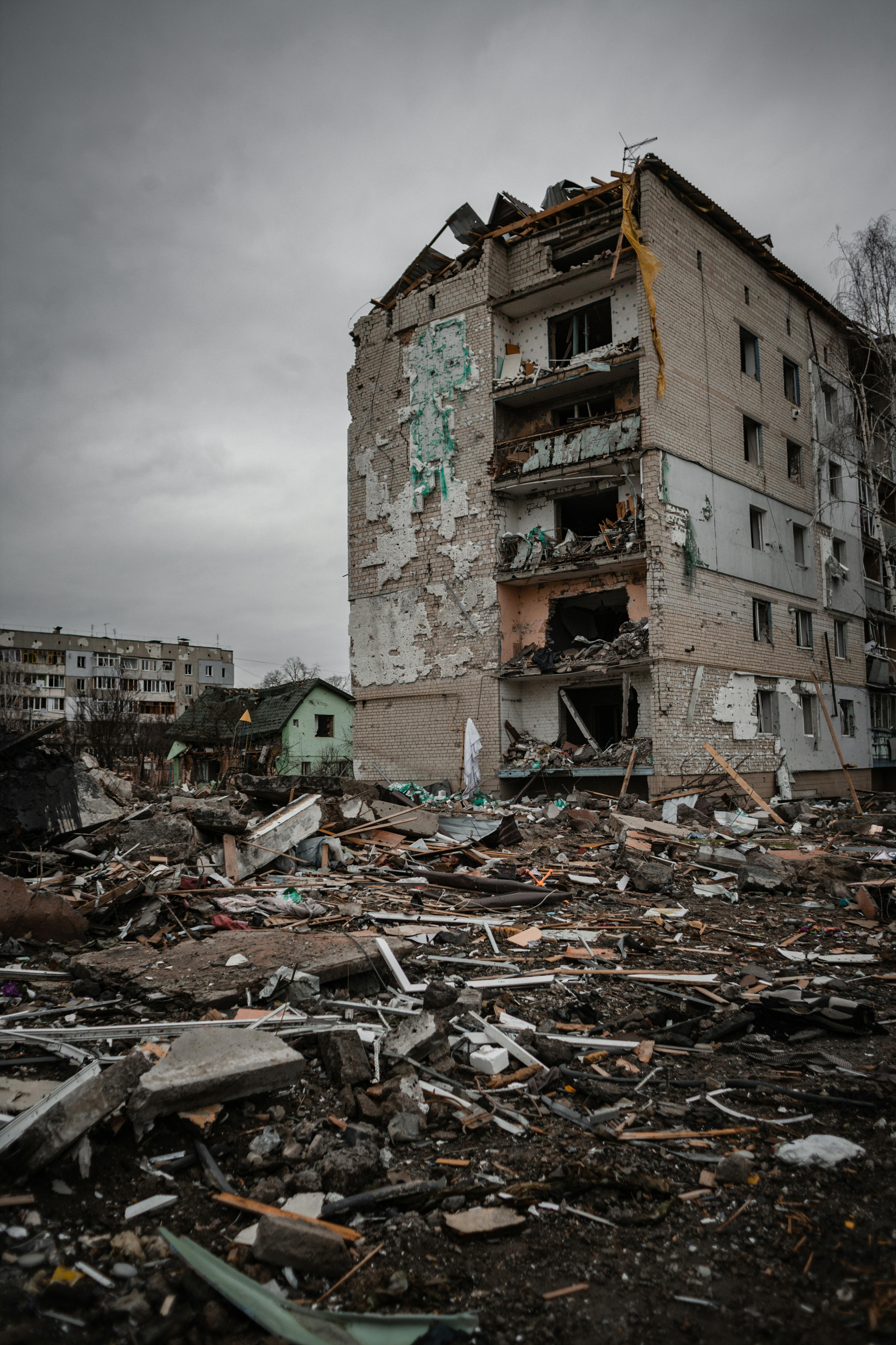
The spatial analysis indicates an uneven distribution of infrastructure damage. Eastern and southeastern regions have experienced the highest destruction, while central and western regions remain relatively less affected. This reflects the concentration of military operations in strategic zones.
<figure data-latex-placement="tbp">
<img src="https://doc.journalspress.com/ucq56d_227170/author_package/media/image2.png" style="height:75.0%" />
<p><em>Source: Conflict data reports.</em></p>
<figcaption>Regional Distribution of Infrastructure Damage in Ukraine</figcaption>
</figure>
## Population Displacement Patterns
The conflict has resulted in large-scale displacement, both internal and cross-border. Populations have moved from high-conflict areas toward safer regions and neighboring countries, following identifiable migration routes influenced by safety and accessibility.
<figure data-latex-placement="tbp">
<img src="https://doc.journalspress.com/ucq56d_227170/author_package/media/image3.jpeg" style="height:75.0%" />
<p><em>Source: UNHCR</em></p>
<figcaption>Spatial Pattern of Population Displacement from Ukraine</figcaption>
</figure>
## Economic and Regional Transformation
The findings show significant economic disruption. Conflict-affected regions have experienced decline in industrial and agricultural productivity, while relatively stable regions have absorbed some economic activities, indicating regional restructuring.
# Analysis
The analysis of the Russia–Ukraine conflict reveals significant transformations across physical and human geographical dimensions. The findings are presented under three major components: land use and environmental changes, population displacement patterns, and economic impacts.
## Land Use and Environmental Changes
The study indicates substantial changes in land use patterns due to the ongoing conflict. Agricultural lands in affected regions have experienced considerable damage as a result of military activities, leading to reduced cultivation and abandonment of farmland. Soil degradation and contamination have further decreased land productivity, while destruction of vegetation has contributed to ecological imbalance. Environmental conditions have also deteriorated due to pollution, infrastructure damage, and disruption of natural systems. Comparative analysis of pre-conflict and conflict-period data suggests a clear decline in land quality and environmental sustainability. Population Displacement Patterns one of the most prominent outcomes of the conflict is large-scale population displacement. The results show a sharp increase in both internal displacement and cross-border migration since the beginning of the conflict. Millions of people have been forced to leave their homes, resulting in significant changes in population distribution. The trend analysis (Figure 1) demonstrates a continuous rise in displacement during the initial phase of the conflict, followed by fluctuations depending on the intensity of military activities.
Spatial patterns indicate that displaced populations are primarily concentrated in urban centers and border regions, where access to resources and safety is relatively higher. This uneven distribution has led to increased pressure on infrastructure, housing, and public services in host areas. The displacement has also altered settlement structures, contributing to rapid and unplanned urbanization in certain regions.
## Economic Impact
The conflict has had a profound impact on economic activities across multiple sectors. The results reveal a significant decline in agricultural production due to land damage and restricted access to farming areas. Industrial activities have also been disrupted as a result of infrastructure destruction and reduced workforce availability. In addition, the service sector has experienced setbacks due to instability and reduced consumer demand. The sector-wise analysis (Figure 2) highlights that agriculture and industry are the most affected sectors, while services have shown relatively moderate decline. Trade disruptions and supply chain interruptions have further intensified economic challenges, affecting both regional and global markets. The overall economic decline reflects reduced productivity, loss of employment, and decreased investment in the affected regions.
## Integrated Geographical Impact
The findings demonstrate that the impacts of the conflict are interconnected and multidimensional. Environmental degradation, population displacement, and economic disruption are closely linked and reinforce each other. For example, land degradation reduces agricultural productivity, which in turn affects livelihoods and contributes to migration. Similarly, population displacement places pressure on economic systems and infrastructure in receiving areas.
Overall, the results highlight that geopolitical conflict leads to significant spatial and structural changes in regional geography. The combined effects on land, population, and economy illustrate the complex nature of conflict-induced transformations and emphasize the importance of an integrated geographical approach in analyzing such phenomena.
# Discussion
The findings strongly indicate that the Russia–Ukraine war has significantly reshaped regional spatial structures. The temporal fluctuations in conflict intensity reflect the dynamic nature of military strategies and operations. The uneven spatial distribution of infrastructure damage confirms that warfare is geographically selective, targeting strategically important regions. This aligns with geopolitical priorities and military objectives. Population displacement patterns highlight the spatial consequences of conflict, where migration follows predictable routes based on safety and accessibility. This has resulted in demographic shifts and increased pressure on host regions. Economic disruptions further demonstrate the interconnected nature of regional systems. The decline in conflict zones and growth in relatively stable areas indicate a spatial redistribution of economic activities. Overall, the integration of spatial analysis with geopolitical interpretation provides a deeper understanding of how conflicts transform regional geography, affecting territorial control, population distribution, and economic structure.
# Conclusion
The present study highlights the significant geographical transformations resulting from geopolitical conflicts, with specific reference to the Russia–Ukraine war. The analysis demonstrates that conflicts are not limited to political and military dimensions but have far-reaching impacts on physical landscapes, human settlements, and economic systems. By adopting a spatial and analytical approach, the study provides a comprehensive understanding of how conflict reshapes regional geography.
One of the key findings of the study is the substantial alteration in land use and environmental conditions. The destruction of agricultural land, degradation of soil quality, and damage to natural ecosystems have created long-term environmental challenges. These changes not only affect current land productivity but also pose serious risks to future sustainability and ecological balance in the region.
Population displacement has emerged as another critical outcome, having significantly altered population distribution and settlement patterns. This has led to increased pressure on urban centers and border regions, resulting in challenges related to housing, employment, and access to basic services. The spatial concentration of displaced populations further highlights the uneven geographical impact of conflict.
The study also reveals the severe economic disruptions caused by the conflict. Key sectors such as agriculture, industry, and services have experienced considerable decline due to infrastructure damage, reduced production, and disrupted trade networks. These economic challenges not only affect the immediate conflict region but also have broader implications for regional and global economic stability.
An important contribution of this study is its integrated approach, which combines physical and human geographical perspectives. By linking environmental degradation, population displacement, and economic instability, the research demonstrates the interconnected nature of conflict-induced changes. This holistic understanding is essential for developing effective strategies to address the complex challenges arising from geopolitical conflicts.
The study further emphasizes the importance of spatial analysis in examining conflict-related transformations. Understanding regional variations and spatial patterns can help policymakers identify vulnerable areas and design targeted interventions for recovery and development. In this context, geographical research plays a crucial role in informing planning and policy decisions in conflict-affected regions. However, the study is limited by its reliance on secondary data, which may vary in accuracy and availability. Future research can incorporate primary data and advanced geospatial techniques to provide more precise and localized analysis. Additionally, comparative studies across different conflict regions may offer deeper insights into the broader patterns and impacts of geopolitical conflicts.
In conclusion, the Russia–Ukraine conflict serves as a significant example of how geopolitical tensions can reshape regional geography across multiple dimensions. The findings of this study underline the need for an integrated and spatially informed approach to understanding conflicts. Such an approach is essential not only for academic research but also for developing sustainable solutions aimed at recovery, resilience, and long-term regional development.
Generating HTML Viewer...
− Conflict of Interest
The authors declare no conflict of interest.
− Ethical Approval
Not applicable
− Data Availability
The datasets used in this study are openly available at [repository link] and the source code is available on GitHub at [GitHub link].