



IntelliPaper
Abstract
Irrational, intensive grazing and overgrazing have determined the degradation of the soil through erosion and compaction, but also the quality decrease of the pastures. The construction of roads and especially forest, county and local roads has led to slope cuts and deforestation, influencing the dynamics of the slope through the occurrence of landslides, runoff and torrentiality, as well as changes in the river bed manifested by the reduction of linear erosion, the intensification of transport and increasing material amounts of accumulation (Demeter, 2006).
The modification of the landscape and by the degradation of the slopes is also influenced by the appearance of paths created by humans or animals, of cart roads causing or favouring the phenomena of trickling, torrentiality or muddy flows (Buloiu, Ionescu, 1986).
Important changes were also brought by the construction of the DN15 national road, both on the relief and on the vegetation and soils. Massive clearings of beech forests mixed with conifers were made and excavations were made in slopes, embankments, embankments and excavations. The use of the land in the area of the Izvorul Muntelui Lake is dominated by forestry activities due to the large share of over 80% of the total surface, either coniferous, deciduous or mixed forests. Along the Bistricioara River valley and the immediate vicinity of the lake, there are larger areas occupied by pastures and complex crops and agricultural land mixed with natural vegetation.
Explore Digital Article Text
I. INTRODUCTION
Soil is a natural component essential for life, as it constitutes the environment for the growth and development of plants, habitat for numerous insects and other organisms, acts as a surface water filtration system, is a deposit of organic substances and especially carbon and support for atmospheric gases. Soil plays a crucial role in an ecosystem by protecting seeds and plants to germinate and grow. Soil performs several important functions that contribute to all ecological cycles (water, carbon, oxygen, nitrogen, biological and geological cycles). It takes nature 100 years to create 2.5 cm of soil, and in 1.5 ha of soil it is estimated that between 5 and 10 tons of animal organisms can live, while man can destroy in a few minutes by improper works or by removing the soil layer, all these habitats. To the natural role of the soil is added its economic importance, because it represents the substrate of agriculture, both of cultivated plants and of animal breeding through fodder plants.
In Romania, 12 classes of soils and 32 types of soils were identified and are mentioned by SRTS 2003, which are carefully monitored in terms of their quality, by ANPM (National Agency for Environmental Protection) and by ICPA (National Research Institute - Development for Pedology – Agro-chemistry and Environmental Protection). In order to evaluate and interpret the level of soil quality, it was important to establish the changes in its properties over time. Unable to measure soil quality directly, we were able to infer it from how it behaves and changes in its properties under different types of agricultural uses.
II. RESEARCH METHODOLOGY
The purpose of the research was the identification of degraded soils, either through erosion on the surface or through the modification of chemical properties, due to natural or anthropogenic processes, in order to achieve the best strategy to reduce or eliminate the ecological and economic effects. Interest in the sustainable protection of the natural environment and soils began at the Congress in Rio de Janeiro and continued with the Sustainable Development Goals of the United Nations Organization that established global directions for solving land and soil problems, with 2015 being declared the International Year of Soils.
The objectives of the degraded lands and the soil cover research were the following:
-
the analysis of the slope morphodynamics in order to establish the specific degradation processes;
-
the identification of the phenomena that determine the elimination of soil fertility;
-the identification of the triggering causes of soil degradation processes (erosion, compaction, contamination, reduction of organic matter, salinization, biodiversity decline).
The soil cover research aimed at: the inventory of physical-geographical factors and their role in shaping the current relief; establishing the types of soil affected by erosion; identification of areas subject to erosion and forms of land degradation; analysis and interpretation of results obtained through field research and laboratory studies; making a plan of measures to prevent and combat land degradation.
2.1 The preparatory stage
The soil profile was executed so that the chosen point was not disturbed by human intervention, and the location was representative of a large area of land (river valleys, slopes, plateaus, depressions). After making each profile, we identified and noted a series of morphological properties: the sequence of horizons and their number, colour, thickness, texture, structure, porosity of the horizons, the presence and type of skeleton, adhesive, neo-formations, and inclusions, present in the upper horizon (Florea, Balceanu 1986). With the help of a roulette, we determined the thickness of a horizon starting from the hypothesis that the upper limit of a horizon represents the lower limit of the next horizon. The colour of the horizons was appreciated both with the naked eye and with the help of the Munssel colour determiner, it being closely dependent on the mineral and organic components in the soil.
For the collection of soil samples, a rectangular pit was made with a spade with one of the vertical walls, smoothed, from which I detached a 5-6 cm thick slice, which I shaped, crushed by hand and inserted one in a bag that I have labelled. Soil samples were collected after analysis and morphogenetic description of the soil profile. The samples were collected in paper bags placed in plastic bags or metal boxes (Fig. 1, 2, 3). In order to be able to do a complete laboratory analysis, we collected 0.5-1 kg of soil as a sample. On the bags and inside them we noted the number and exact location of the profile, date, soil type, depth and horizon from which it was harvested. The samples were taken starting from the solification rock, so from the bottom up and from each horizon and sub-horizon. If the horizon was thin, under 10 cm thick, I took a single sample and if it was thicker I took 2-3 soil samples.
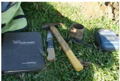
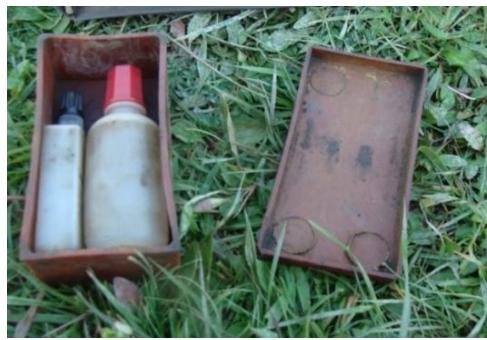 Fig. 1: Field tools that were used in the profile analysis (photo 2018)
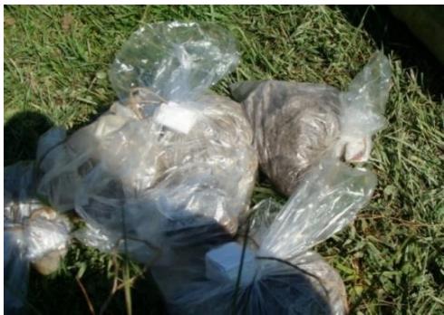 Fig. 2: Solution for determining soil pH (photo 2018)
In the laboratory, the collected samples were subjected to physical and hydro-physical determinations, and the following morphological and physical properties were analysed, such as: the transition from one horizon to another, the colour of the horizon, the frequency of spots, the texture of the horizon, the skeleton present in the analysed horizon, the structure of the horizon, adhesive, soil plasticity, soil porosity, soil effervescence, soil neo-formations, roots, granulometric fractions, humus, total nitrogen, pH in water, phosphorus extractable in ammonium lactate acetate, potassium extractable in ammonium lactate acetate, soil volumetric weight and soil reaction (some of the instruments and apparatus used are shown in figures 4, 5, 6).
The determination of soil pH was carried out in aqueous soil suspension, so that the pH value represented the logarithm with changed sign of the activity of hydrogen ions in the respective suspension (pH = -log H+).
The determination of mobile potassium was carried out by extraction, with ammonium acetate-lactate solution according to the Egnér-Riehm-Domingo method. The results were expressed in ppm of K.
For the determination of mobile or accessible phosphorus in ammonium acetate-lactate, the Egnér-Riehm-Domingo method was used, so that the extracted phosphate anion was determined colorimetrically as "molybdenum blue", and the results were expressed in ppm of P.
Humus was determined on the basis of organic carbon, identified by the method of wet oxidation and Titrimetric Walkley-Black dosing in the Donut modification, the results being expressed as% humus =% organic carbon x 1.724.
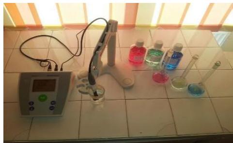
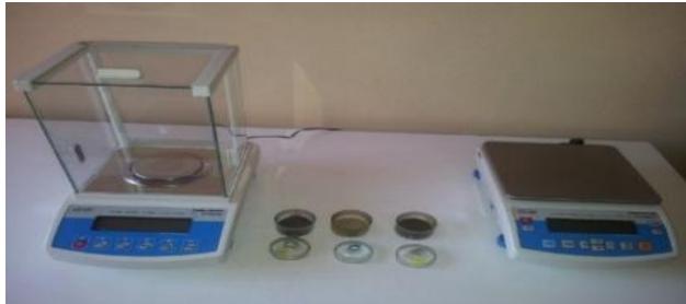 Fig. 3: SevenEasy-Mettler-Toledo pH-meter for measuring the pH (photo 2018)
The stage of analysis, processing and interpretation of the data was carried out after the completion of the pedological mapping, the field research and the laboratory stage and consisted in the creation of interpretive maps, some graphs, the correlation of the data obtained with different classification and degree measurement systems of soil erosion.
We studied, from a cartographic point of view, the types of soils in the studied area, establishing the existing correlation between them, the way of land use and the degree of soil erosion. The influence of the classic tillage system and the direct and indirect effects of these practices on soil properties were analysed. In order to establish the influence of agricultural works on the physical properties of the soil, we carried out determinations on the ground and in the laboratory, collecting samples and interpreting the results, as well as monitoring the evolution of crops throughout the vegetation period in order to establish as accurately as possible their perspective (Choy, Limm, Sagong, Engel, Tang, 2005). The identification of degraded lands and the monitoring of their evolution was carried out differently, depending on the intensity of the erosion phenomenon and the natural or anthropogenic causative factors, with the aim of establishing an optimal strategy to reduce or eliminate the negative effects on habitats or to preserve vulnerable lands. The analysis of agricultural techniques and practices was carried out from the perspective of evolutions over time, simultaneously with the identification of soil types and subtypes, the analysis of geomorphological processes in the studied area and their role in the pedogenesis process or in erosion processes.
The final or synthesis stage was the one in which we concluded the essential aspects of the research, resulting both from the analysis of the physical-geographical and geomorphological characteristics of the studied area, as well as from the interpretive part, specifying at the same time the improvement measures and forecast regarding the different types of soils in the area. The entire work was supported by photographs, diagrams, sketches, figures, maps, illustrative material, which support the statements or conclusions stated in the text. In order to establish a cause-effect relationship, we carried out an inventory and mapping of the surfaces affected by different types of degradation and through an analysis of the data collected on the ground, the existing correlation between economic activities, land degradation and the effects on human settlements was established.
2.2 Scientific Content
This form of erosion on the surface is extremely harmful, being difficult to notice, it can lead to the loss of the horizon with humus but also of the fertilizing elements. Deep erosion includes ditches, gullies and ravines, as well as torrents, which have as consequences, the erosion and soil removal and slope imbalance. Thus, lands lose their productivity both from an agricultural and forestry point of view, deep erosion and landslides contribute at least 50% of the total erosion, while surface erosion, landslides have the biggest contribution. The gullies pave the way for the emergence of relief forms that cause the erosion to deepen. Combating them can be achieved with the help of ploughing along the axis of the ditch (Dârja, 2000).
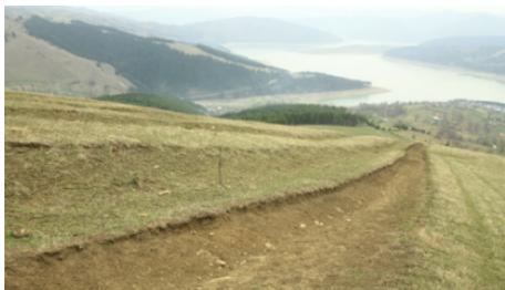 Fig. 4: Technical balance Radwag-ps 1200/C/2 for determining the mass of samples in laboratory spaces (photo 2018)
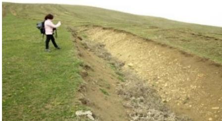 Fig. 5: Deep soil erosion in the vicinity of Izvorul Muntelui Lake (photo April 2016)
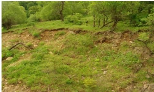 Fig. 7: Landslides on cleared land in the village of Ceahlău (photo May 2018)
From the analysis of the map of land susceptibility to landslides, it can be seen that a very high degree of susceptibility is present on 6% of the analysed surface, and a high degree on 7% of the surface, the steep slopes bordering the valley of the Bistriciora River, and its tributaries - Grințieșul Mic and Grințieșul Mare, the slopes belonging to the Bistriția Mountains, as well as the eastern slopes of the Ceahlău Mountains, which belong to Picianorul Ciocanu, Picianorul Verde and Obcinele Chica Baicului. It is present on the western slopes of the Stânișoara Mountains that come into contact with the waters of the lake, in the area of the towns of Poiana Teiului, Poiana Largului, Roşeni, Topoliceni, Hangu, Chiriţeni, Grozăveşti.
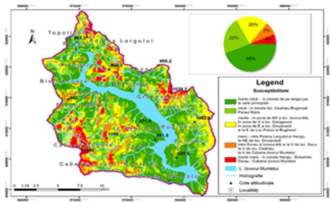 Fig. 8: Landslide susceptibility map in the Izvorul Muntelui lake area
From the analysis of the susceptibility map to landslides in the area of the Izvorul Muntelui Lake, it can be observed that the lands in the immediate vicinity of the lake and those along the tributary valleys of the lake and their tributaries have a very low susceptibility (45% of the territory) and a low susceptibility (22% of the area): Schit, Pintilic, Hangu, Grințieș, Bistricioara, Muncel, Răchitișul Mare, Potoci, Bolătău, Secu, and their tributaries. An average degree of susceptibility to landslides 20% of the lands, which belong to slopes with medium inclinations that are also properly forested and that predominate on the left side of the lake, but are also present on the right side at lower altitudes.
2.3 Evolution of the soil profile
In order to analyse the soils, we made 10 profiles, the location of which can be seen on the adjacent map, after which the disposition of the profiles followed the investigation of various types of soil located at different altitudes and on different parental materials, as well as with various uses (both in the countryside and in urban areas, in tourist areas or on mountain slopes, in the vicinity of roads or in more isolated areas) the following types of soils are described: podzols (profile 10), eutricambosols (profiles 1 and 9), districambosols (profiles 3 and 6), lithosols (profiles 2, 4,7) and luvosols (profile 8). Since the profiles were made for the study of land degradation, following human activities, it was analysed from a chemical and structural point of view, the first horizon A, being the one primarily affected by different forms of degradation. Only profile number 1, made in the Ceahlău Mountains, has a complete chemical analysis of all horizons.
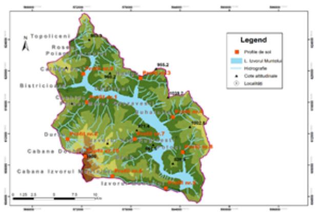 Fig. 9: Map of the positioning of the soil profiles made in the area of the Izvorul Muntelui Lake
The soil profiles were distributed as follows: soil profile no. 1, located in the Ceahlău mountains, at an altitude of 499 m; soil profile no. 2, located in the Ceahlău mountains, in the Durău resort at an altitude of 834 m, soil profile no. 3, located in the Stânișoara mountains, Hangu commune, at an altitude of 695 m; soil profile no. 4, located in the Stânișoara mountains, on the territory of Buhalnița commune, Ruginești village, at an altitude of 652 m, soil profile no. 5, located in the Ceahlău mountains, Izvorul Muntelui village, at an altitude of 610 m, soil profile no. 6, located in the Ceahlău mountains, near the Izvorul Muntelui cabin at an altitude of 820 m, soil profile no. 7, made in the Ceahlău mountains, near the town of Izvorul Alb at an altitude of 640 m, soil profile no. 8, made in the Stânișoara mountains, on the territory of the commune of Hangu in the outskirts of the village of Potoci at an altitude of 686 m, soil profile no. 9, located in the Stânișoara mountains on the territory of the commune of Poiana Teiului in the village of Călugăreni at an altitude of 566 m and soil profile no. 10, made in the mountains of Ceahlău in the vicinity Dochia cabin at the altitude of 1771.
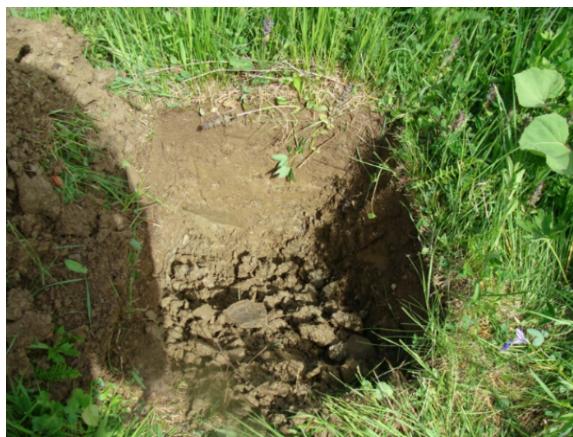 Fig. 6: Erosion ditch in the alpine area of the Stânișoara Mountains (photo April 2016)
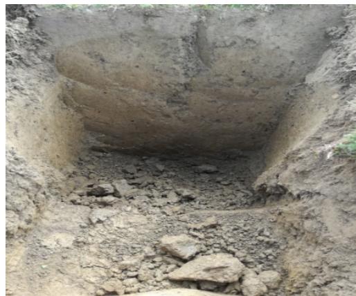 Fig.10: Soil profile no. 6, lithic districambosoil (photo May 2018) and Fig 11 Soil profile no. 7, lithosoil
According to the recent classification of land degradation (Florea 2003), their degradation aims at either the deterioration of physical, chemical, biological or complex characteristics, or the destruction of the soil, through displacement, coverage or loss of land. In the studied area, soil degradation processes can be physical (destruction, compaction, crust formation), chemical (acidification, leaching, chemical pollution), biological (reduction of the population of organisms, or pollution with pathogenic agents), complex (depletion of fertility) and displacement processes or phenomena (hydraulic erosion, mass movements, excavation), covering with non-fertile sediments or ash waste (tailing deposits), as well as land losses (following the construction of houses or economic objectives, roads, or even the development of Izvorul Muntelui Lake). According to I.C.P.A 1987, the degree of soil erosion in the studied area, depending on the thickness of the horizon remaining on the surface, in the profiles made falls into the category of strongly eroded in the case of a profile, moderately eroded (3 profiles) and eroded weak (6 profiles). Depending on the skeleton content the analysed soils fall into the following content classes, by volume% limits: soils without skeleton or weak-skeletal (below 25%) are those in the profiles (1,5, 7, 8, 9, and 10) strongly skeletal soils, having between 51 and 75% those of profiles 2, 3, 4, and 6.
Texture is one of the important properties of the soil because it influences the way humus accumulates, the way agricultural works are carried out, the absorption capacity as well as the water, thermal and nutritional regime. According to SRTS 2003, soils can be classified into a textural class based on the proportion of clay (below 0.02 mm), silt (0.02-0.002) and sand (2-0.2 mm).
{"image_source":{"path":"images/d06b8778f90856206661ec8a60d57f961281a00e9bcef1cce612b8c93f33321e.jpg"},"content":"","chart_caption":[{"type":"text","content":"Fig. 12: The percentage of skeletal content in the volume of soils analysed in the 10 profiles"}],"chart_footnote":[]} In the analysis of the 10 soil profiles, we established the soil texture, by examining the soil with the naked eye, under a magnifying glass, but also by simple tests, of the samples extracted from the upper horizon, such as feeling when rubbing in a wet state, rural, modelling in a wet state, plasticity, dry consistency, adhesion. The soils analysed in the 10 profiles, according to SRTS 2013, have medium class textures, 5 falling into the clay textural class (at profiles 1, 5, 6, 7, 10) and 5 falling into the clay class -sandy (profiles 2, 3, 4, 8, 9).
{"image_source":{"path":"images/e5dea2dda1fcede86cfa40520011344afef6d3bc4a1c7414557d496cd52c929a.jpg"},"content":"","chart_caption":[{"type":"text","content":"Fig. 13: Distribution of particle size fractions in the 10 soil profiles made"}],"chart_footnote":[]}
The inclusion in this class of medium textures ensures good and very good conditions for all processes in the soil, but at the same time it also allows structural stability, a good hydric and aerobic regime, thanks to optimal porosity and permeability, as well as an adequate storage capacity of water. These properties allow a good development of plants, as well as the realization of agricultural works, in a relatively easy way and in various humidity values.
The structure of the soil was researched in the field, where we assessed the type of structure, the degree of development or degradation, but also through laboratory analyses, which focused on the hydrostability and mechanical analysis of the structural elements. In general, the soil structure in the analysed profiles is predominantly granular in profiles (1, 4, 5, 6, 7, 8, 9, 10) and columnar only in profiles 2 and 3. By observing the structure, in the field and taking into account the properties from this and from the result of pressing, palpating the soil and the way in which the component structural aggregates break down, it follows that the soils generally have a moderately developed structure, in which case between 25-75% of the soil mass has structural aggregates that can be easily observed being moderately stable.
{"image_source":{"path":"images/ef4211b944b3b88dc54ba1abf3c55297ae122cdf3ff71d7d9a2ed01d13e6485c.jpg"},"content":"","chart_caption":[{"type":"text","content":"Fig. 14: The share of total nitrogen in the soils analyzed in the 10 profiles"}],"chart_footnote":[]}
The content of mobile phosphorus (extractable in ammonium acetate-lactate P-AL), calculated according to the Égner-Riehm-Domingo method, in which the phosphate anion is extracted and determined colorimetrically as molybdenum blue, and the results are expressed in ppm P, fall within the soils analysed in two content classes: small in the case of profile number 10 where 18 ppm is recorded and extremely low content class in the case of all the other profiles (1, 2, 3, 4, 5, 6, 7, 8, 9) where mobile phosphorus values are below 4 ppm. The role of phosphorus in the soil is important because phosphate ions contribute to the formation of compounds that constitute fertilizers for plants, being responsible for both the development of the roots and the plant as a whole.
{"image_source":{"path":"images/ff23380f99c24d6a147176cd366f7c6acab94fc64583bf91b056588ff6a25717.jpg"},"content":"","chart_caption":[],"chart_footnote":[]} {"image_source":{"path":"images/5771f3371560b31061e84a8205f7cbe7470c5ebec258dd1ef60f7fe2ded834ab.jpg"},"content":"","chart_caption":[{"type":"text","content":"Fig. 15: The share of mobile phosphorus in the 10 analysed soil profiles"},{"type":"text","content":"Fig. 16: Share of extractable potassium in the 10 analysed soil profiles"}],"chart_footnote":[]}
The mobile potassium content was calculated according to the method of determining mobile potassium by extraction with ammonium acetate-lactate solution, according to the Égner-Riehm-Domingo method and the results were expressed in ppm, of K, and the values obtained fig.110 fit the analysed soils in 3 classes of mobile potassium content (extractable to acetate – lactate): low content, between 66 and 130 ppm, in the case of profiles 2, 5, 6, 7, 8 and 9, medium content between 131 and 200 ppm, in profiles 1 and 4 and high content between 201 and 300 ppm in profiles 3 and 10.
IV. RESULTS AND CONCLUSIONS
Soil erosion in the studied area is due to geomorphological, gravitational, mechanical processes, affecting approximately 44% of the surface area of the Izvorul Muntelui Reservoir. Acidic soils, lithosoils and brown-woody soils, located under pastures and hayfields, representing approximately 21% of the studied area, are affected by weak erosion. Soils with moderate erosion from the brown-eumesobasic and brown-luvic category represent 6% of the analysed area, and the rest is represented by soils with strong erosion of the eroded eumesobasic brown type and erosion soils.
Landslides, triggered or reactivated, in the area of the Izvorul Muntelui Lake, affected several settlements in the area such as: Poiana Teiului, Hangu, Bicaz, Păstrăveni, Făueni, Cuejdel. In the last five years, these localities have been affected by more than 900 landslides, 160 affecting homes, 20 affecting the stability of the DN 15 road and requiring drainage, consolidation and slope stabilization works. On the slopes belonging to Ceahlău and Stânișoara mountains, forms of surface and deep erosion were identified, which resulted in the total or partial removal of the soil layer, and the removal of degraded lands from the agricultural circuit. Soil pollution with chemical fertilizers and pesticides was identified by increasing the potassium content, up to 4 grams /100 grams of soil. Following the ingestion of pesticides, the population in the area is affected by functional disturbances of the endocrine, respiratory, cardiovascular and renal systems and apparatus.
In the analysis of the forms of land degradation, in the area of the Izvorul Muntelui reservoir, an important role was played by the study of physical-geographical factors, with contributions in modelling the relief. The geological factors that were taken into account were the paleogeographic evolution of the studied area, the composition of the substrate and the predominance of Cretaceous and Paleogene flysch. The neotectonic movements determined the orientation of the valleys in transverse directions, compared to the direction of the flysch structure, which also determined the orientation of the surface erosion.
The hydrological factors, the most important are the hydrological regime of the Bistrita and its tributaries as well as the hydrological facilities, especially the Izvorul Muntelui-Bicaz. For this purpose, average monthly flows on the Bicaz River during the period 2007-2016 and the level variations of the Izvorul Muntelui Lake during this period were analysed.
Due to land degradation, the activity of wood exploitation and its transport, along the Bistrița valley to Piatra Neamț, is affected, through the traditional activity of rafting. On certain areas, the forests were completely removed due to erosion and deforestation, especially in the valleys of the Bistricioara, Hangu, Bicaz rivers. Shepherding, practiced since antiquity, is still present today in the Ceahlău Mountains, in the Stânelor Glade and the Maicilor Glade, an activity also affected by land degradation, through the quantitative decrease of pastures.
The types of soils, identified in the area of the Izvorul Muntelui Lake, are: differentiated by altitude, comprising from the foothills to the peaks, three complexes: the complex at the base of the slopes, includes soils damaged by landslides, raw and young soils, and brown-acidic soils. Low-elevation slope soils are brown-crude, flysch-brown-young, brown and yellowish-brown, tan-brown, brown and brown-podzolite, while the high-altitude slope soil complex includes soils brown-acidic soils, brown and yellow-brown acid soils, humiferous brown-acidic soils, brown acid-podzol soils, podzols.
The use of land, in the studied area, is differentiated by altitude, thus at low altitudes potato cultivation is practiced, there are also lands in the suburbs of localities or located under roads, railways, hydrotechnical constructions, along with other vegetables, at medium altitudes on slopes the lands have forest destination, but also pastures and natural meadows, and at higher altitudes, there are areas occupied by forests, conifers and areas declared natural reserves (Secu, Ceahlău).
The soils in the area of the Izvorul Muntelui Lake present various types of evolution, properties and a geographical distribution correlated with the specifics of the Carpathian flysch. In the studied area, the following types of soils were identified, with different weights belonging to the classes: cambisoils (brown-acid soils), protisoils (lithosoil), black soils (rendzin). The most common type of soil is brown-eumezobasic soil (cambisoils class) spread over 37% of the analysed surface. The soil texture is predominantly sandy-clay and loamy-clay. From the hypsometric analysis, 4 distinct steps of relief could be identified, which correspond to 4 steps of vegetation floors, belonging to beech, mixed beech and conifer forests, conifers and a subalpine floor. The erosion values in the studied area are between 0 and over 8 tons per ha/year and from the correlation of the databases regarding the susceptibility to erosion processes, it follows that there are no eroded lands or very vulnerable to erosion. Among the technical and edaphic factors that influence the agricultural production capacity, the soil represents the most important component. The physical and chemical properties of the soil that directly influence plant growth are siltation, alkalization, texture, permeability and humus content. The main forms of soil degradation in the studied area are: determined by fluvial, cryo-nival, rain-denudation and gravity processes. Some accelerated by human intervention, manifested by deforestation, improper agricultural practices or chemical applications.
In the studied area, land degradation is due to: landslides, landslides, mass displacements and torrential erosion. The soil degradation processes can be physical (destruction, compaction, crust formation), chemical (acidification, leaching, chemical pollution), biological (reduction of the population of organisms, or pollution with pathogenic agents), complex (depletion of fertility), displacement processes or phenomena (water erosion, mass displacements), excavation, covering with non-fertile sediments, or with waste such as ash, tailings deposits, as well as land losses (following the construction of housing or economic objectives, roads, or even the landscaping of Izvorul Muntelui Lake).
According to I.C.P.A1987, the degree of soil erosion in the studied area, depending on the thickness of the horizon remaining on the surface, in the profiles made, falls into the category of strongly eroded in the case of a profile, moderately eroded (3 profiles) and weakly eroded (6 profiles). In the soils analysed through the 10 profiles, the porosity is high, which indicates a high water circulation capacity and high permeability. Degradation of the structure can occur through excessive agricultural work, when the soil is either too dry or too wet, or when it is excessively fertilized.
In the analysis of the 10 soil profiles, we determined the soil texture, these being included in the class of medium textures, which ensure good and very good conditions for all processes in the soil, but at the same time allow structural stability, a good hydric and aerobic regime, due to optimal porosity and permeability, as well as an adequate water storage capacity. These properties allow a good development of plants, as well as the realization of agricultural works, in a relatively easy way, and in various values of humidity.
From the chemical analysis of the surface horizon in each profile, it can be observed that in the studied area the acid pH predominates, with values between 4.83 and 6.32, present in profiles 1, 2, 5, 6, 8, and 10, a slightly acidic pH, with values between 6.15 and 6.32. Cultivated plants require slightly acidic or neutral soils, while the natural vegetation of deciduous forests, conifers and alpine meadows is adapted to acidic soil. In half of the profiles made, the humus content has values between 0-5% in the first 20 cm, and values higher than 14% in 3 profiles out of 10.
Soil fertility is reflected by indicators that can be grouped into 4 categories: agrophysical (texture, structure, porosity, compaction, useful edaphic volume, agrophysical fertility index), hydrophysical (hydrophysical indices and the relationship with water, permeability, water movement in the soil, the ability to retain water, phreatic intake), agrochemical (soil reaction, degree of saturation in bases, content of nutrients, ion exchange capacity) and agrobiological (humus, biological activity and phytosanitary status). In addition to the humus content in the profiles made, we also analysed other chemical elements necessary to increase the development of plants such as: nitrogen, potassium and phosphorus, finding that they do not have large weights in the chemical composition of the soils, on the contrary, the soils fall into classes with a low and medium content on these indicators. Overall, the fertility of the soils in the area allows the development of deciduous and coniferous forests on the slopes, the cultivation of potatoes and some fruit trees in depressions, the cultivation of hay, and the development of natural meadows in the higher areas, without the need for other chemical fertilizers.
The main works to prevent and combat the action of geomorphological processes, which determine soil erosion in the Izvorul Muntelui Lake area, are those aimed at landslides: retaining walls, levelling, modelling, drainage, catchment of springs, anchorages, open channels, counter banks, thresholds, embankments, bank reinforcements, stepped slopes; combating the ravines, levelling the gullies, as well as the execution of some agricultural works that provide anti-erosion protection to the soil. Some of these works were carried out simultaneously or later with the construction of the reservoir and the most frequently used form of erosion prevention is the afforestation of sloping lands.
Conflict of Interest
The authors declare no conflict of interest.
Ethical Approval
Not applicable
Data Availability
The datasets used in this study are openly available at [repository link] and the source code is available on GitHub at [GitHub link].
Funding
This work did not receive any external funding.
References
Cite this article
Related Research


Special Issue
Launch a focused special issue to highlight research, emerging trends, and expert insights in your academic field.
