




IntelliPaper
Abstract
Long-term and efficient operation of a reservoir largely depends on the correct solution of problems considering such principal aspects as the forecast of fluid and solid river flows, taking into account climatic and anthropogenic factors; the evaluation of the amount of sediment deposited in the reservoir; the prediction of the possible accidents scenario and assessment of their consequences. The purpose of this paper is to determine the volume of eventually accumulated soil mass in a reservoir. As an example, the calculations are given for the Aaparan Reservoir located in the Republic of Armenia. The study has been based on the initial hydrometric data on the flow rate and sediment load, the design characteristics of the reservoir. Three principal methods have been chosen for the calculated estimation of the deposited sediment volume. Field measurements in the Aparan reservoir were carried out using precise geodetic means. Comparison of the obtained calculation results and field measurements enables to assess the reliability of the calculation methods, and to reveal the inaccuracies of a number of initial data. Despite the significant discrepancy between the obtained values of the deposited silt volume, the recorded maximum value does not exceed 1.5% of the reservoir useful volume. The calculation results make it possible to arrive at a conclusion that over half a century of operation, the design parameters of the Aparan reservoir remain practically unchanged. This proves that the Kasakh River, which flows into the reservoir, has a very weakly expressed alluvial regime.
Explore Digital Article Text
I. INTRODUCTION
Reservoirs are actually unique public infrastructures for storing and regulating river flows. They occupy a special place among water bodies and support people's social and economic activities by supplying water and controlling floods. On the other hand, reservoirs make their important contribution to ensuring the security of national economy. The construction and operation of reservoirs have a long history, however, some issues of long-term, safe and efficient operation of many structures are still insufficiently studied. Here we can note the need for the following studies:
-
reliable and long-term forecasting of fluid and solid river water flows' dynamics related to significant changes in both climatic and ecological conditions, and anthropogenic impacts [Doll P. & Muller (2012), Tokmajyan H.V. (2016), Dobrovolsky S.G. (2011), Vardanyan T.G. (2007)],
-
periodic assessment of the decreasing useful volume of the reservoir, due to sedimentation processes occurring there and, in accordance with this, develop a prospect planning and repair program designed to clean up deposits or reduce the amount of silt in the stream [Baljyan P.H. & Baljyan V.P. (2013), Baljyan P.H. & Sedrakyan S. M. & Manukyan A. S. (June, 2014), SP 58.13330.2012 (2003)],
-
determination of characteristics of possible washout and destruction of earth dams, and forecasting the boundaries of the wave flow propagation [Prudovsky A.M. (1998), Zhang H. & Youssef H. & Long H.D. & Kahawita R.A. (1992)].
During operation, sediment, carried away by water, wind or ice, is accumulated in the reservoir. Generally, in the bottom part of a reservoir, a certain "dead" volume is normatively specified for sedimentation (Fig. 1). However, the practice of operation of small and medium-sized reservoirs, built in mountain-foothill zones shows that a small part of silts - mainly suspended particles, is often deposited in their dead volumes [Baljyan P.H. et al. (June, 2014), Davranov G.T. & Fyrlina G.L. (2017), Kamara Usman (1993)]. In many cases, the form of sedimentation is more dependent on the reservoir drawdown schedule. Two options are possible here:
-
During the year, the water mark is at the banked-up water level (BWL);
-
Before the spring flood, the useful volume of the reservoir is used, and the water mark comes down to the dead volume level (DVL).
In the first case, the entrained sediment and coarse fraction of suspended particles move downstream by the flow and settle down to the bottom of the useful volume of the reservoir (Fig. 1).
In the second case, we have the following picture: during the spring floods, when the reservoir begins to fill, the front of sediment deposition from the lower elevations begins to rise upstream to the BWL. In the summer dry season, a considerable part of accumulated water is supplied for household needs and technological activities, as a result the water level in the reservoir is gradually lowered, exposing the upper sections of the deposits forming small islands. The river flow here begins to wash away a small part of the deposited sediment and move them to the lower levels. When the useful volume of the reservoir is fully used, the sediment begins to fill the dead volume. The described process is repeated in subsequent years. In both cases, the main part of the deposited sediment occupies the useful volume, thereby gradually decreasing the regulating capacity of the reservoir (Fig. 1)
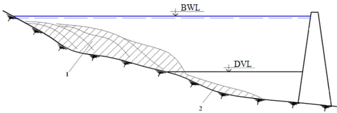 Fig. 1: Schematic sketch of the typical pattern of the longitudinal sediment deposition in the reservoir during operation.
1- deposits of larger sediment particles in a useful, regulating volume,
2- deposits of small particles in the dead volume
There are frequent cases when, due to an incorrect forecast of the alluvial regime of a waterway, within three to four decades, most of the reservoir basin is filled with soil mass and as a result the structure is practically becomes out of order. The foregoing enables to come to a conclusion that the study of the sediment regime of the waterway and the calculation of the volume of sediment deposited in the reservoir is of great scientific and practical importance, including planning of various cleaning operations.
Therefore, for the long-term and effective operation of reservoirs, the following tasks are of very important scientific and practical importance for the national economy:
-
study of the alluvial regime of the watercourse,
-
calculation of the volume of sediments deposited in the reservoir,
-
development of engineering measures to reduce the amount of sediment flowing into the reservoir,
-
planning and carrying out work on cleaning sediment deposited in the reservoir.
There are about seven dozen small and medium-sized reservoirs with earth dams in operation in the Republic of Armenia. The present paper presents research results carried out in the Aparan Reservoir, built from 1962 to 1966 on the Kasakh River. The catchment area of the river at the dam site is 591 km2. The Aparan Reservoir, with a total volume of 91 million m3 and a useful volume of 81 million m3, is one of the ten largest reservoirs in the Republic of Armenia. The height of the dam is 53 m, the length along the ridge is 200 m. The operation of the Aparan Reservoir has significantly reduced the flow of water from Lake Sevan for irrigation purposes.
The purpose of the present paper is to determine the volume of sediment deposited in the Aparan Reservoir on the basis of hydrological calculations and field measurements.
This is the first time such studies are carried out in reservoirs of Armenia. The obtained research methods and results can be used to study other reservoirs of the Republic of Armenia.
Theoretical basis
II. PROBLEM STATEMENT AND METHODOLOGY
River sediment is of importance in the process of soil mass deposition in the reservoir, both in a suspended state and moving in the lower layers of the flow (entrained sediment). Consequently, the total amount of sediment is due to the alluvial characteristics of the waterway on which a structure is installed. Having sufficiently reliable data on sediment flow and its granulometric parameters, it is possible to build a model and set a mathematical problem to determine the volume of sediment in the reservoir and solve it. In field studies, the design topographic material of the reservoir bowl was used. The research objects are the water and alluvial regimes of the Kasakh River, the original bottom of the Aparan Reservoir and the bed load. Accordingly, the subject of this study is the construction of a mathematical model designed for determination of sediment deposits in the reservoir by the incoming river flow. Collected hydrometric data of the average monthly water and sediment discharge were processed by hydrological methods, Field measurements were carried out in the reservoir and 2D and 3D models of sediment along the length of the reservoir were developed.
The study was carried out within the framework of the program of the research base laboratory "Hydraulic engineering" NPUA with the financial support of the RA MESCS Science Committee.
III. RESEARCH RESULTS
In calculating the volume of sediments bedded in the Aparan Reservoir, the hydrometric data of the Kasakh River were used. In order to obtain more reliable results, these hydrological calculations were carried out using three methods:
-
with direct use of measured hydrometric data on sediment discharge;
-
using the values of the sediment discharge calculated from the fluid flow of the Kasakh River;
-
based on data from regional maps of river water turbidity.
At the stage of acquiring the initial material, it turned out that the water-flow record of average monthly and average annual discharges of suspended sediments of the Kasakh River is very short. At the same time, there are no measurements of the entrained sediment. Contrary to this, to establish the fluid discharge of the river during 1966 -2018 sufficiently detailed hydrometric measurements were carried out. There is also a regional map on the distribution of the average turbidity of waterways, compiled on the basis of processing the results of extensive hydrological studies [Surface water resources of the USSR, vol. 9, no. 2. Chapter 10 - Bassein r. Araks (1976)].
Method one. To calculate the volume of the sediment, we used the data on the discharge of suspended sediments measured at the measuring station "Vardenis", installed on the bed of the Kasakh River, a few kilometers above the Aparan Reservoir. In the section of the measuring station, the catchment area of the river is , and in the section of the dam - . The values of the solid discharge measured at the measuring station were transferred to the section of the reservoir by means of hydrological recalculation (Table 1). The tabulated data show that the average annual flow rate is 0.36 kg/s.
Table 1: Average monthly flow of sediment of the Kasakh River in the section of Aparan Reservoir, calculated using the same flow rates of the Vardenis measuring station, (kg/s)
| Year | Month | |||||||
| 4 | 5 | 6 | 7 | 8 | 9 | 10 | 11 | |
| 1976 | 0.14 | 0.18 | 0.06 | 0.008 | 0 | 0 | 0,001 | 0,001 |
| 1977 | 0.11 | 0.06 | 0.018 | 0.002 | 0 | 0 | 0 | 0 |
| 1978 | 0.09 | 0.24 | 0.017 | 0.003 | 0 | 0 | 0 | 0 |
| 1979 | 0.02 | 0.01 | 0.02 | 0.004 | 0,003 | 0.002 | 0.001 | 0.001 |
| 1980 | 2,25 | 0.16 | 0.024 | 0.003 | 0.006 | 0.005 | 0.005 | 0.001 |
| Maximum | 11,6 | 14,7 | 0.41 | 0.58 | 0.10 | 0.029 | 0.030 | 0.01 |
| Monthly average | 1.47 | 1,21 | 0.099 | 0.053 | 0.015 | 0.009 | 0.006 | 0.004 |
| Average annual flow of sediment from 1976 to 1980. - 0.36 kg/s | ||||||||
During the period of the reservoir operation, the volume of sediment inflow is calculated by the ratio
where is the sediment flow (kg/s); T is the estimated time interval (s); is the density of sediment deposits (kg/m ).
Method two. In this case, in determining the sediment volume, the values of the sediment flow will be used, calculated for the liquid flow of the Kasakh River. It should be noted that there was a fairly long hydrological record of river discharge. The values of the fluid flow, measured at the Vardenis measuring station, were transferred by recalculation to the section of the reservoir (Table 2). Based on the analysis of a large number of field measurements for the waterways of the Eastern Transcaucasia, a below empiric regularity is proposed that connects the flow of suspended sediment and water [Surface water resources of the USSR, vol. 9, no. 2. Chapter 10 - Bassein r. Araks (1976)]
Taking into account Eq. (2) for the values of Table 2, the corresponding values of sediment were calculated (Table 3). In this case, the average annual flow rate is 0.95 kg/s. This value can be used to establish the flow rate of the sediment and that part of the suspended sediment, which can be bedded in the reservoir.
The total volume of sediment deposited over 54 years in the Aparan Reservoir in the second method is calculated similarly to the first. The result is:
Table 2: Average annual flow rates in the section of the Aparan Reservoir recalculated according to fluid flow rates of the Vardenis measuring station
| Year | Water flow, $m^3/s$ | Year | Water flow, $m^3/s$ | Year | Water flow, $m^3/s$ |
| 1966 | 2.71 | 1984 | 1.35 | 2002 | 1.52 |
| 1967 | 2.75 | 1985 | 0.49 | 2003 | 1.31 |
| 1968 | 4.00 | 1986 | 0.88 | 2004 | 1.51 |
| 1969 | 3.67 | 1987 | 1.82 | 2005 | 2.47 |
| 1970 | 2.65 | 1988 | 2.76 | 2006 | 2.39 |
| 1971 | 2.60 | 1989 | 0.71 | 2007 | 1.70 |
| 1972 | 4.10 | 1990 | 2.58 | 2008 | 1.13 |
| 1973 | 1.63 | 1991 | 1.17 | 2009 | 0.95 |
| 1974 | 1.51 | 1992 | 1.30 | 2010 | 1.40 |
| 1975 | 2.24 | 1993 | 0.83 | 2011 | 1.64 |
| 1976 | 2.77 | 1994 | 0.92 | 2012 | 1.04 |
| 1977 | 1.26 | 1995 | 0.70 | 2013 | 1.29 |
| 1978 | 3.30 | 1996 | 0.78 | 2014 | 0.76 |
| 1979 | 1.09 | 1997 | 0.91 | 2015 | 1.13 |
| 1980 | 2.04 | 1998 | 0.63 | 2016 | 1.37 |
| 1981 | 0.85 | 1999 | 0.98 | 2017 | 1.04 |
| 1982 | 0.91 | 2000 | 0.82 | 2018 | 0.98 |
| 1983 | 1.03 | 2001 | 0.75 |
Table 3: Average annual flow discharge in the section of the Aparan reservoir, calculated by fluid flows of the Kasakh River
| Year | Sediment flow, kg/s | Year | Sediment flow, kg/s | Year | Sediment flow, kg/s |
| 1966 | 1.86 | 1984 | 0.96 | 2002 | 1.07 |
| 1967 | 1.88 | 1985 | 0.37 | 2003 | 0.93 |
| 1968 | 2.69 | 1986 | 0.63 | 2004 | 1.07 |
| 1969 | 2.47 | 1987 | 1.27 | 2005 | 1.70 |
| 1970 | 1.82 | 1988 | 1.89 | 2006 | 1.64 |
| 1971 | 1.78 | 1989 | 0.52 | 2007 | 1.19 |
| 1972 | 2.75 | 1990 | 1.77 | 2008 | 0.81 |
| 1973 | 1.14 | 1991 | 0.84 | 2009 | 0.69 |
| 1974 | 1.07 | 1992 | 0.92 | 2010 | 0.99 |
| 1975 | 1.55 | 1993 | 0.60 | 2011 | 1.15 |
| 1976 | 1.89 | 1994 | 0.66 | 2012 | 0.74 |
| 1977 | 0.89 | 1995 | 0.51 | 2013 | 0.92 |
| 1978 | 2.24 | 1996 | 0.57 | 2014 | 0.56 |
| 1979 | 0.78 | 1997 | 0.66 | 2015 | 0.81 |
| 1980 | 1.42 | 1998 | 0.46 | 2016 | 0.97 |
| 1981 | 0.62 | 1999 | 0.71 | 2017 | 0.75 |
| 1982 | 0.66 | 2000 | 0.60 | 2018 | 0.70 |
| 1983 | 0.74 | 2001 | 0.55 | 2019 | - |
| Average annual value of suspended sediment flow - 0,95 kg/s | |||||
Method three. According to the regional map the basin of the Kasakh River is located on the territory of which the turbidity of waterways averages . Taking into account the values of the Table 2 liquid runoff (volume) of the river in the period 1966 to 2020 turns out to be equal to 2.74 billion . Then, with the average value of the turbidity of the flow, the total mass of suspended sediment for 54 years will be equal to: billion kg or 0.52 million m . Moreover, 40% of this volume is deposited in the reservoir, i.e. 0.21 million m .
IV. RESULTS OF THE STUDY
Method one: Studies carried out by this method show that particles with a diameter less than 0.05 mm are transitory and do not deposit in water bodies. Their share is up to 60% of the total amount of suspended sediment [Surface water resources of the USSR, vol. 9, no. 2. Chapter 10 - Bassein r. Araks (1976)]. At the same time, for the waterways of the Araks River, the ratio of suspended and entrained loads has been established. The average amount of entrained sediment, accounting for 46% of the total suspended sediment volume [Ter-Minasyan R.O. (September, 1978)]. Thus, according to the empiric dependence of Eq.(1) for the period of operation of the Aparan Reservoir (1966 to 2020), the total
volume of sediment deposition in the first variant will be kg/s
where the denominators indicate the values of the densities of the suspended and entrained particles, respectively.
Method two: The total volume of sediment deposited in the Aparan Reservoir over 54 years, where kg/s, is calculated similarly to the first method. As a result we get
Method three. The amount of tractional load in the reservoir, which is 46% of the total volume of suspended sediment, will be 0.24 million m3. Consequently, in the third method, the total sediment volume deposited in the Aparan reservoir over 54 years will be 0.45 million m .
V. DISCUSSION
Thus, according the suggested three methods of calculation three values of the volume of sediment deposited in the reservoir were obtained: according to the first method 0.31 million m , according to the second - 0.80 million m and according to the third - 0.45 million m , respectively,. The smallest value corresponds to the calculations carried out on the basis of the measured values of the suspended sediment flow of the Kasakh River. The other two volumes of sediment are derived from hydrological calculations. Logically, the first value should be more accurate. However, the hydrological record of measured flows (Table 1) compared to the fluid flow of the river (Table 2) is very short, which does not allow the result of the first method to be taken as a basis and consider it as a most correct one.. Comparison of the calculation results with actual data will allow assessing the degree of reliability of each calculation method and identify the reasons for possible discrepancies.
To carry out field studies on the basis of a topographic map of the area, a 2-D model of the Aparan Reservoir was developed before it was put into operation. The characteristic sections were selected and the areas connecting the model and the terrain were marked. The measurements in the reservoir were carried out during the period when the useful volume of water (81 million m ) was used and the water level in the reservoir dropped to DWL. A rover was used to determine the coordinates of the sediment surface on the dried-up part of the reservoir (Fig. 2), and in the dead volume, a depth gauge equipped with GPS was used (Fig. 3).
Coordinates of 398 points have been measured, 360 of which in the dried-up part, and the remained - in the dead volume. These data were transferred to the produced 2-D model of the reservoir and 2-D and 3-D models of the reservoir bed surface were developed, respectively, before the reservoir was put into operation and at the present time (Figs. 4 and 5).
In Fig. 5 dark color indicates areas of sediment deposition. The upper section of deposits with a length of about 1.1 km is formed by sediment transported by the main stream of the Kasakh River. Their volume is 0.69 million m . They are entirely located in the usable volume of the reservoir.
The lower section of deposits with a length of about 0.8 km is mainly formed by sediment of the left and right tributaries of the Kasakh River (lower part of Fig. 4). The volume of the deposit is 0.63 million m . Most of them (0.4 million m ) are located in the dead volume area. Between these areas, over a length of about 0.9 km, there are practically no deposits; the original reservoir bottom remained unchanged.
Thus, the total amount of sediment deposited in the Aparan reservoir is 1.32 million m . Of this amount, 0.92 million m is used for the useful and 0.4 million m for the dead volume of the reservoir.
When comparing the calculated and field study results, it is necessary to take into account that the calculated three values of the sediment volume were obtained on the basis of hydrological and hydrometric data of the Kasakh River. The influence of the sediment behavior of the two tributaries of the river on the reservoir was not taken into account due to the lack of any measured data on these waterways. Based on this, the values of the calculated volume will be compared with the actual volume of the upper section of the sediment obtained from field studies, i.e. with a value of 0.69 million m .
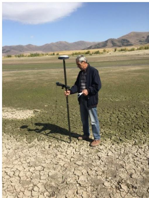
Fig. 2: Coordinate measurement of the deposit surface by the rover

Fig.3: Measuring coordinates of the deposit surface with a deep gauge
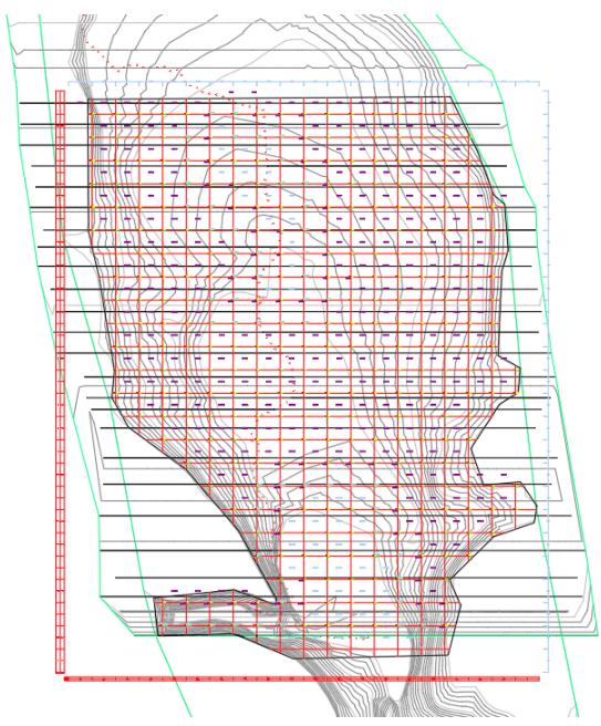
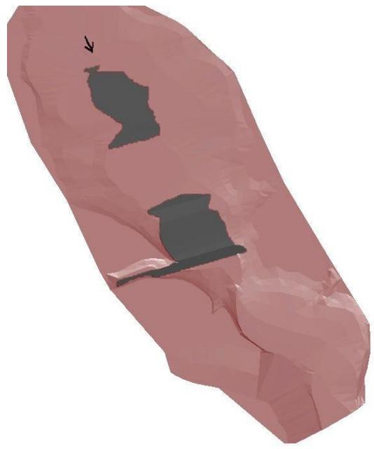
Fig.4. 2: D model of the reservoir bowl Fig.5. 3: D model of the reservoir
According to the above described three calculation methods the following volumes were obtained, respectively: 0.31 million m ; 0.45 million m and 0.80 million m . The first two calculated values of the volume of deposits are significantly smaller than the actual one. Such a discrepancy in the case of the Kasakh River can take place: as a result of a reduced estimate of the volume of the sediment settled down to the of the water body bottom (it is assumed to be 46% of the amount of suspended particles); due to inaccuracies in the course of measuring the flow of suspended sediment and in the mapping of the turbidity of regional waterways; and finally, in the presence of the above both disadvantages.
As for 0.80 million m of the volume calculated according to Eqs. (1) and (2), its difference with the actual volume of 0.69 million m is 14%. The resulting small discrepancy shows that under the conditions of the problem under consideration, the third method gives fairly good results. For the final assessment of the calculation methods applicability, it is necessary to carry out similar studies in a number of other reservoirs in the region.
The proposed methods of cleaning and repairing can be used both for operating reservoirs and those planned for the future. Based on the forecast of the characteristics of their siltation, it is very important to carry out measures for its cleaning. Analysis of the results of studies of the sediment regime of a number of rivers and the process of siltation of reservoirs in the Republics of Armenia and Artsakh allowed the authors to propose a number of engineering measures that significantly slow down the process of sediment deposition and reduce the useful volume. Among them:
Engineering measures
-
In the case of the construction of a new reservoir or for a slightly silted existing reservoir, the amount of sediment carried along by the flow can be significantly reduced with the help of a sediment-retention waterworks facility, which can be installed above the reservoir or in the riverbed itself or next to it. Bottom sediments and large suspended particles will be deposited in its pre-calculated volume. The accumulated sand and gravel soil can be periodically removed and used for construction. A similar solution was used in the design of a small reservoir on the river Selav Mastara (RA).
-
If the reservoir is sufficiently silted up, then in order to improve its regulated capacity, it is necessary to plan measures for the partial or complete cleaning of sediment deposits, which can be carried out mechanically or by hydraulic flushing. The first method is quite laborious and expensive, so mechanical cleaning can be used for small reservoirs.
To clean relatively large reservoirs, it is advisable to use the hydraulic flush method. In the practice of operating these structures, this method has been used. For example, the reservoir Matagis, built on the river. Tartar (Republic of Artsakh). For 40 years of operation, more than 60% of its volume was occupied by nanosam. Due to the accident of the bottom outlet gate, the river runoff in a dense layer of sediments washed away and carried away more than 500 thousand m of soil for two years (Fig. 6, 7). The width of the flushing ravine varied within 70-120 m, the average depth was 9-10 m.
In both measures to clean up sediment deposits, to improve the filtration protection of the reservoir bottom, its surface can be covered with a waterproofing layer of the mixture created using pump materials and polymer-mineral material (PMM). Such a layer of 10-15 cm is easy to fit and does not require a lot of resources.
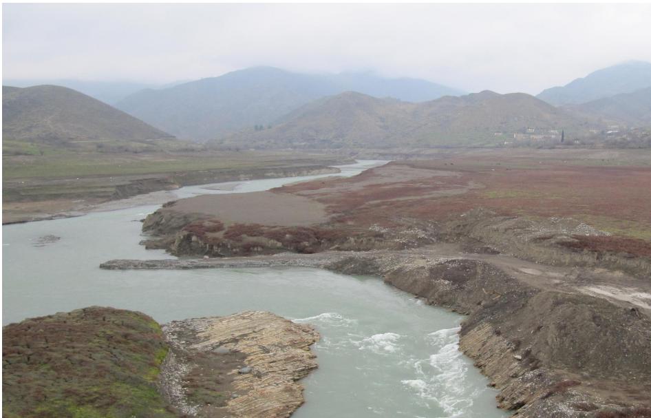 Fig. 6: Flushing ravine in the sediments of the Mataghis reservoir
VI. CONCLUSIONS
Comparison of the calculated and measured values of the sediment volume with the design values of the total and useful volumes of the reservoir (respectively, 91 million m and 81 million m ) shows that the total volume of sediment in any case does not exceed 1.5% of the total volume of the reservoir. It means that during 54 years of operation, the design parameters of the Aparan Reservoir underwent very small changes. The result is unexpected, since studies in a number of reservoirs of the mountain-foothill zone show [Baljyan P.H. et al. (June, 2014), Baljyan P.H. & Kelejyan H.G. & Poghosyan A.A. & Namatyan N.T. (2020)] that during the same period of sediment deposition in them occupies a significant part of the basin of the reservoir (10 to 20%). And in some cases, this percentage reaches up 50 to 60%.
The third method is more reliable for assessing the sediment regime of the river under the conditions of the Aparan Reservoir. During 54 years of operation, sediment occupied 1.5% of the total volume of the reservoir. At the same time, the useful volume decreased by 1.1%, and the dead volume - by 4.0%. It can be stated that the volumetric characteristics of the Aparan Reservoir have undergone little changes during the operation period. The results obtained show that the alluvial regime of the Kasakh River is quite weak and very favorable for structures, accumulating river runoff. It can be assumed that in the course of further operation, the regulatory characteristics of this structure will not undergo marked changes.
The methods proposed in the article can also be used for other reservoirs, and allow, based on the forecast of their siltation, to plan and implement measures for their cleaning or making other management decisions. In particular, it is possible to clean up part of the islands created due to sediment in the summer, and thereby increase the useful volume of the reservoir, which can be used for irrigation of agricultural land. For reliability, the cleaned bottom of the reservoir can be covered with a waterproofing layer of the mixture created using pump materials and polymer-mineral material (PMM) [SarukhanyanA.A. & Vartanyan A.A., & Veranyan G.G. & Tokmajyan H.V. (November, 2020), Tokmajyan Vache H. & Vardanyan Arevshad A. & Galstyan Armavir G. & Miqayelyan Nver A. (2020)]. Such a tamped layer of 10-15 cm is easy to fit and does not require large expenditures of resources.
Conflict of Interest
The authors declare no conflict of interest.
Ethical Approval
Not applicable
Data Availability
The datasets used in this study are openly available at [repository link] and the source code is available on GitHub at [GitHub link].
Funding
This work did not receive any external funding.
References
Cite this article
Related Research


Special Issue
Launch a focused special issue to highlight research, emerging trends, and expert insights in your academic field.
