


IntelliPaper
Abstract
Traditional master planning often relies on decadal, static documents that fail to account for the rapid spatio-temporal dynamics of modern urban environments. This divergence between planned and actual land use creates systemic inefficiencies in urban governance. This research proposes a GeoAI-driven framework—a formal systems approach that integrates Geomatics, Artificial Intelligence (AI), and Deep Learning (DL) into a live, updatable "City Engine." The framework utilises Convolutional Neural Networks (CNN) for automated change detection and GIS-based heuristic rules for instant plan versioning. By shifting the master plan from a static atlas to a dynamic "body of knowledge," the proposed system enables real-time monitoring, evaluation, and publishing of urban development strategies. The results demonstrate that such a system can significantly bridge the implementation gap, offering a scalable model for smart city governance and sustainable regional development.
Explore Digital Article Text
Introduction
Urban planning plays a vital role in balancing socioeconomic vitality with environmental preservation. Traditionally, this balance has been managed through top-down master plans. However, these plans often struggle to remain relevant as urban environments evolve at a pace that can outstrip administrative update cycles. To address this challenge, this paper proposes a paradigm shift toward the Dynamic Master Plan. By leveraging a cutting-edge GeoAI portal, we envision a planning system that acts as a “live” digital twin of the city. This innovative approach not only documents the city's current state but also intelligently formulates, evaluates, and updates urban data in real time, enhancing decision-making processes. City planning encompasses essential tasks such as effectively distributing populations, allocating land use, preserving the natural environment, and developing transportation and infrastructure systems. These efforts are crucial for stimulating economic vitality and improving the overall health and well-being of communities. The authors recognise that the traditional preparation of city master plans can be time-consuming and labour-intensive, often requiring updates every 10 to 15 years. This paper aims to provide valuable insights and methodologies for the inception, preparation, updating, monitoring, and evaluation of city master plans within a dynamic, real-time framework. By adopting this approach, cities can maintain a comprehensive overview of future development trajectories, significantly expediting the planning process. One promising strategy involves utilising technology to continuously monitor and track developments, trends, and population shifts, providing enhanced oversight of individual plans. Additionally, AI-driven technologies can help identify projects with a higher likelihood of success, allowing urban planners to prioritise initiatives that align with community needs. Furthermore, engaging citizens in the decision-making process is crucial; this participatory approach ensures that projects reflect residents' desires while simultaneously educating them about the complexities of city-wide planning. When geographical data is meticulously mapped using Geographic Information Systems (GIS) and a mathematical model allocates land across an urban area, the expected outcome is a comprehensive map that illustrates diverse land-use designations, such as residential, commercial, industrial, and public spaces. This model can also produce a detailed land-use allocation table indicating the total acreage assigned to each type.
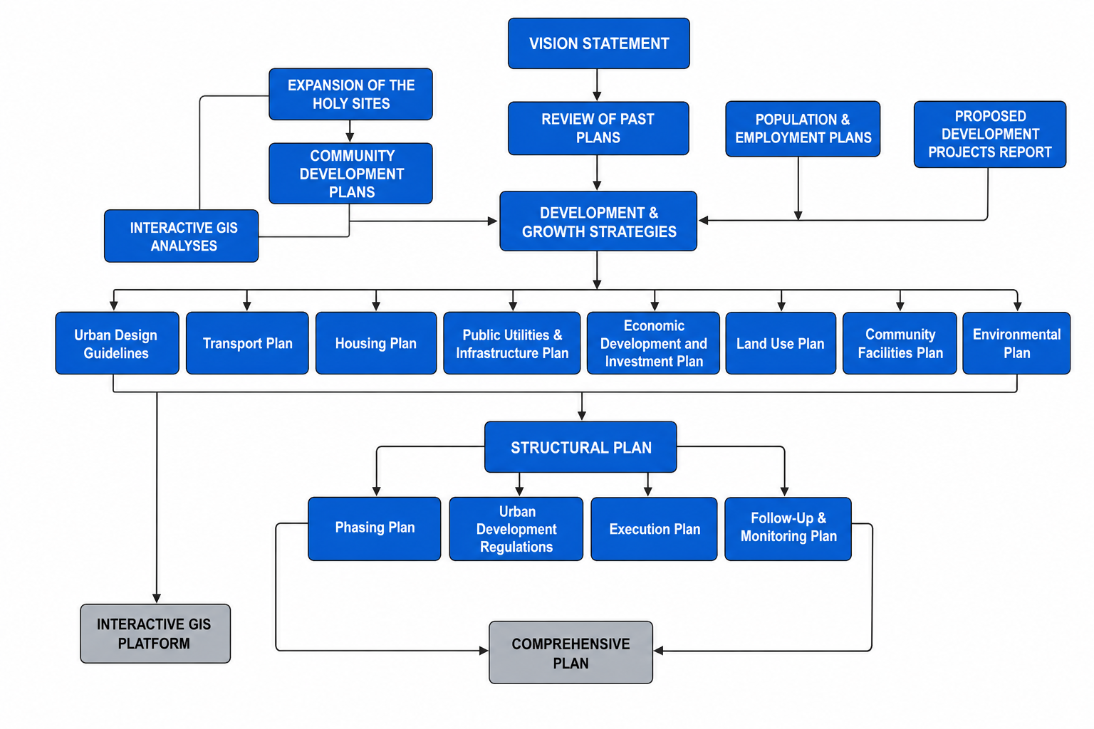
Globally, various technological frameworks, including GIS, satellite imagery, and artificial intelligence, are being harnessed to formulate and update master plans and to track urban changes effectively. This paper aims to address contemporary challenges in urban planning by highlighting innovative approaches and solutions tailored to the unique needs of different regions. Through collaboration and the integration of advanced technologies, we can pave the way for sustainable and responsive urban development (Figure [fig:top-down-approach]).
Further, this paper offers a new perspective on the master plan, envisioning it as a dynamic, seamless, live, and instantaneous body of knowledge about the city. Using a state-of-the-art portal, a city engine is designed to formulate, evaluate, monitor, update, and publish data intelligently, enabling the master plan's continual refinement. As a result, cities can maintain a comprehensive overview of future development, which facilitates quicker processes. One idea is to use technology to monitor and track developments, trends, and population shifts in real time while also improving the tracking of individual plans. GeoAI-driven technologies can help identify which projects are more likely to succeed, thereby allowing planners to prioritise those initiatives.
Moreover, involving citizens in the decision-making process can help cities determine the activities and projects that best meet residents' needs and desires while also educating them about the complexities of city-wide planning. When data is GIS-mapped, and the mathematical model is formulated to allocate land across an urban area, we expect the results to yield a map of the metropolitan area with land allocated according to the model's parameters. This map would include information about residential, commercial, industrial, and public space allocations, along with other more specific land-use designations. Additionally, the model would generate quantitative outputs in the form of a land-use allocation table showing the total acreage designated for each land-use type. Worldwide, technological frameworks that utilise geographical information systems, satellite imagery, artificial intelligence, and other technologies are being employed to formulate, update, and track changes to master plans (Zhang, L., & Liu, X. (2022) (Figure [fig:current-conditions]).
Literature review
Kim and Tran (2018) evaluated comprehensive plans by comparing their content and format against best practices. They concluded that plans often need to catch up to best practices in their content and form, generally needing more attention to tactical implementation plans and evaluations. Lahti, Finland, has created a policy that combines city strategy with master planning in a cyclical process (https://link.springer.com/chapter/10.1007/978-3-030-46136-2_5#auth-Kaisa-Granqvist & https://link.springer.com/chapter/10.1007/978-3-030-46136-2_5#auth-Raine-M_ntysalo, 2020). This is an example of utilising statutory planning frameworks as resources in strategic planning. Stanton (2019) called for a master plan update to integrate hazard mitigation, resiliency strategies, and community interest into the plan. Wolfram et al. (2019), on the other hand, attempted to develop a "smart city analytics platform" called Wolfram Urban Foundry. This platform gives city planners a high-level view of data from multiple municipal departments and sources. It enables faster, more detailed data analysis of these sources, helping planners make informed decisions when developing master plans. Wolfram Urban Foundry also offers urban planning software, including 3D visualisation tools, traffic simulations, and geographic modelling tools to help cities better understand the needs of their citizens. Dutta (2012) analysed the spatiotemporal patterns of land-use dynamics in the urban and peri-urban areas of Lucknow, India, to assess the extent to which they diverge from the official master plan. Kolobov (2022) has discussed the environmental impacts of the master plan as an integral part of the city plan. Inclusion in master planning within the context of urban transformative capacity was addressed by Wolfram (2019) to provide helpful policy lessons for cities facing transitions. Such a transformation can be captured efficiently in a dynamic and robust planning system. Su and Qian (2020) have examined master plan adjustments in Ordos City, China, and the resulting overbuilding and collapse of the real estate market. They suggest transforming towards a more socio-environmentally inclusive approach to planning, with conscious governance to ensure sustainability. They add insight into the interactions between neoliberal planning practices and development realities and demonstrate how strong state capacity can be utilised to encourage or tackle such practices.
Using data analysis and a Back Propagation neural network model, Jianzho et al. (2014) explored the mechanism of land-use change in Guangzhou over 15 years to ensure the effective utilisation of limited land resources. https://www.researchgate.net/profile/Robert-Beauregard-2 and Colomina (2011) analysed the current plan for Amman, Jordan, which combined elements of master planning and strategic planning while incorporating governmental reorganisation, national development concerns, and branding. It documents how planning was linked to implementation to build planning capacity. Tian and Shen (2011) have explored the extent of plan implementation in the context of rapid urban development, using the grid overlay method to compare current land use with the land use plan and analysing any discrepancies between the two using the Guangzhou city master plan. Further research examines why plan implementation does not align with the plan set out by officials, focusing on different land-use types and the spatial unit of planning management. Overall, the research seeks to bridge the gap in evaluating plan implementation caused by methodological difficulties in empirical studies. Byambadorj et al. (2011) examined the effects of land reforms on urban land-use planning in Mongolia's capital, Ulaanbaatar, since the 1990s, drawing on interviews with city, national, and local government officials conducted as part of the master plan process.
Building on previous research, Peter and Yang (2019) focused on urban planning for economic development, highlighting the growth of the capital and largest city, Dar es Salaam. However, its growth has not been carried out in accordance with the city's master plans, and improvements to the urban environment are needed. A call has been made for sustainable urbanisation to address environmental problems. It is suggested that master plans should be designed as an integrated, comprehensive strategy to support this kind of urban development. Shahraki (2022) has demonstrated how planning and design techniques can facilitate tourism development within a municipality's master plan. He provided various practical tools to achieve these aims, including land-use policies for urban development and centralised and symmetric urban design models for sustainable regional/urban development. Other studies, such as Hasymi et al. (2022), have also emphasised the importance of the tourism industry, local contexts, and capacity in master plans.
Pleshkanovska (2019) covers the legislative and regulatory framework for the city of Kyiv. He examines the evolution of models of the spatial organisation of the city's territory, the fallibility of the statutory requirement for the indefinite validity of the master plan, the dynamics of the city's population, and the correlation between the city's population size and other social and economic indicators. Cortinovis and Genelitti (2016) have noted that urbanisation affects urban planning, leading to overcrowding and overburdening existing infrastructure in urban areas and megacities.
In their discussion of polycentricity as part of city master plan development, Cheng and Shaw (2017) identified the main differences in the application and practice of polycentricity. They highlighted the need to adjust master plans for future spatial structures. Gupta and Francis (2010) noted differences in city planning and implementation between cities in developed countries and those in the developing world. He focused on the political economy of cities and on disparities in urban development practices between developed and developing cities.
In Europe, technological frameworks significantly bolster local urban development and sustainable planning. For instance, innovations such as Strabo and artificial intelligence in France are employed for comprehensive land-use planning, data acquisition on the natural environment, and enhancing urban planning processes (Smith, 2022). Similarly, aerial drone technology is utilised in Switzerland and Germany to analyse traffic flow and enhance public safety measures (Jones & Müller, 2023). These drones provide critical real-time data, enabling more efficient urban management and emergency response (Johnson & Brown, 2023). Such technological implementations highlight the pivotal role of innovation in advancing a sustainable urban future.
Likewise, technological frameworks are increasingly integral to urban planning and environmental management in the United States, mirroring global trends towards smarter cities. In California, deploying artificial intelligence (AI) is pivotal in addressing multifaceted environmental challenges. AI systems are employed to manage air quality, predict respiratory disease outbreaks, and anticipate wildfire conditions, demonstrating the potential of technology to enhance public safety and health (Smith et al., 2022; Johnson & Lee, 2023). Meanwhile, Chicago exemplifies the use of geographic information systems (GIS) to streamline urban management. These systems enable the efficient creation and maintenance of databases about energy consumption, water resources, and transportation networks, facilitating data-driven decisions (Brown, 2024). The strategic integration of such advanced technologies underscores a significant evolution in how municipalities address urban and environmental issues, highlighting a shift towards sustainable and resilient urban ecosystems.
Materials and methods
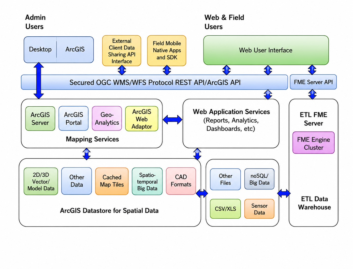
To effectively integrate contemporary city planning concepts, strategies, scenarios, and technologies, this paper proposes conceptualising the master plan as a dynamic, seamless entity. This living "body of knowledge" is structured around an advanced city engine designed to formulate, evaluate, monitor, update, and publish the master plan's contents through an innovative portal. The methodology outlined here encapsulates the essential components and processes necessary for creating and continuously updating master plans. Commencing with the fundamental planning approaches—top-down and bottom-up—this paper elucidates their theoretical and practical applications in city planning, emphasising the importance of incorporating these strategies to promote comprehensive urban development.
a) The bottom-up approach, known for its incremental and participatory nature, highlights citizen involvement in crafting community-specific solutions. This method not only enhances public input and the adaptability of the master plan but also fosters local ownership and improves dialogue between stakeholders, aligning with heightened sustainability imperatives and international standards such as those established by ISO and the UN Sustainable Development Goals (UNSDG).
b) Conversely, the top-down approach, or strategic planning, typically involves developing a comprehensive blueprint that prioritises objectives determined by government actors (Russo, 2016). While this approach is efficient in fostering a unified vision, it often limits stakeholder engagement, underscoring the need for balance and integration with advanced technological frameworks.
c) Deploying technological frameworks, including geomatics technologies, aerial photography, mapping, and satellite imagery, is vital in modern city planning. Geographic Information Systems (GIS) technology consolidates diverse data sets to facilitate sophisticated urban analysis and strategic decision-making. Paired with artificial intelligence and deep learning, these technologies enable the creation of a dynamic georeferenced spatial database essential for real-time formulation, monitoring, and updating of the master plan.
d) To sustain the master plan's relevance and effectiveness, there is a strong emphasis on establishing key performance indicator (KPI)-focused targets grounded in international standards to benchmark city performance, ensuring alignment with global sustainable city rankings.
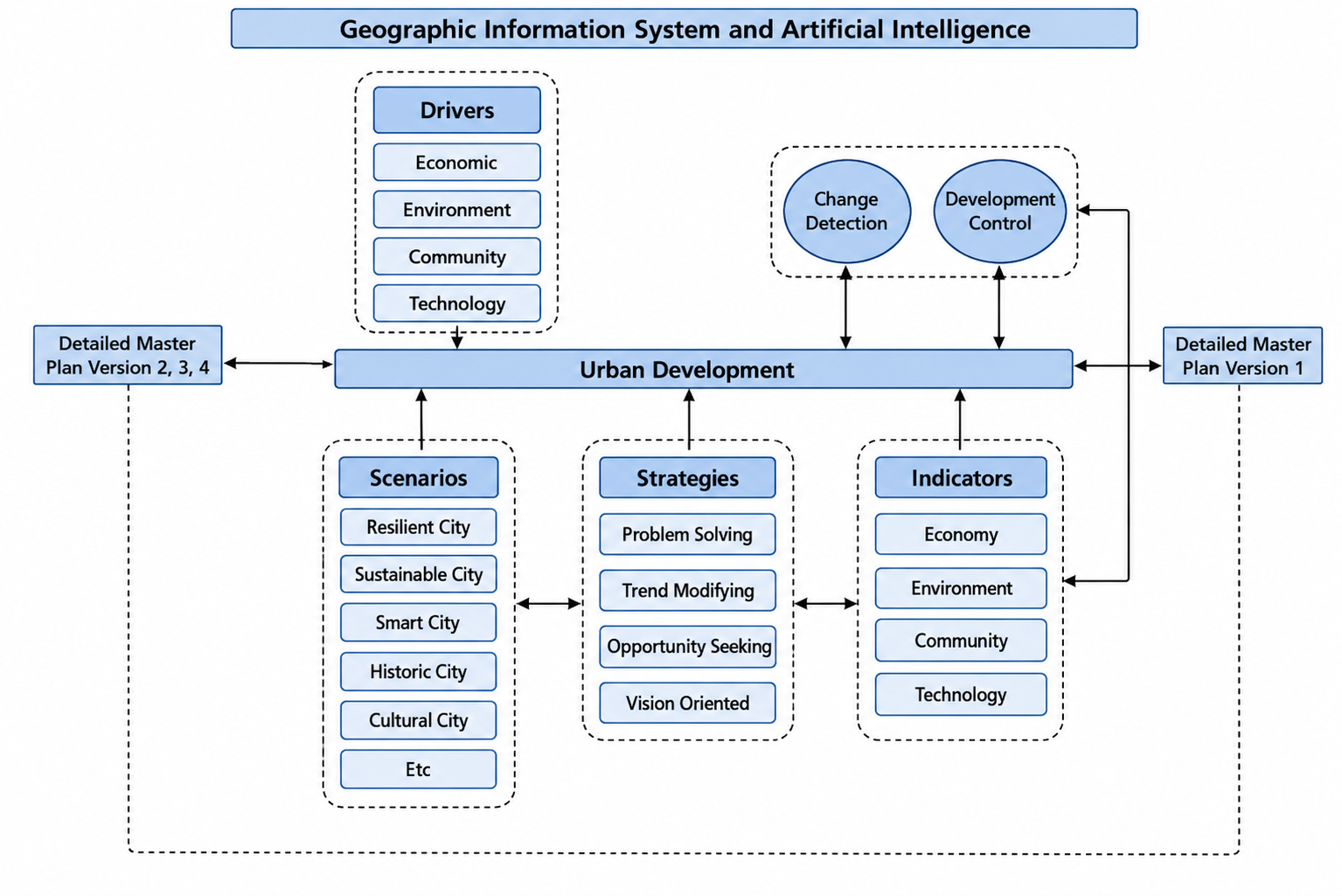
e) The cyclical revision and real-time versioning enabled by these advanced technologies transform the dynamic city master plan into a perpetually current entity, eliminating the traditional need for periodic reviews and updates. This methodology proposes a new approach to city planning that adeptly responds to the complexities of modern cities by strategically integrating stakeholder engagement and technological innovation (see Figure [fig:proposed-geoai-framework]).
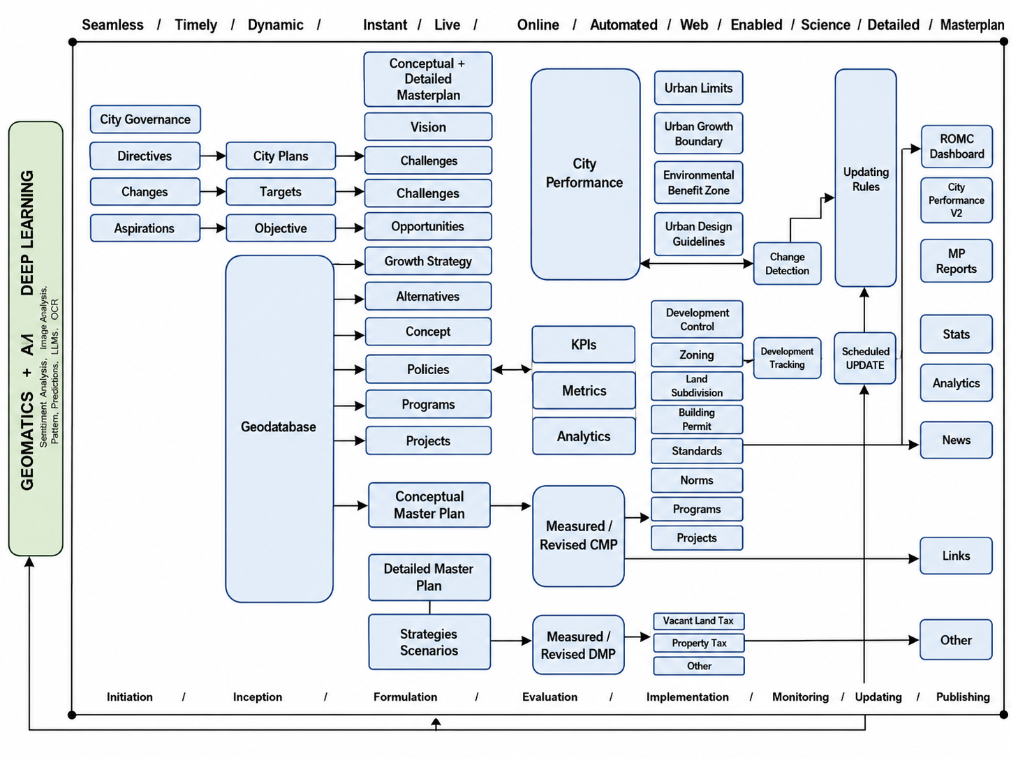
To move conceptual planning as shown in the above schema, the proposed GeoAI framework is envisioned to operationalise a multi-layered computational pipeline comprising:
-
Deep Learning for Automated Change Detection — The engine utilises semantic segmentation via U-Net architectures to process high-resolution satellite imagery (see, for instance, Zhu & Liu, 2022; Bastin & van der Meer, 2023).
-
Feature Extraction — The model identifies land cover classes (such as built-up areas, green spaces, and infrastructure) with a targeted precision of over 90% (Wang & Zhao, 2023; Zhang & Li, 2022).
-
Bi-Temporal Analysis — This process compares imagery stacks from and , where the system automatically flags deviations from the master plan, such as unauthorised urban sprawl or delayed infrastructure projects and incorporates machine learning techniques to identify deviations from established planning frameworks (Srinivasan & Jha, 2022).
-
Heuristic GIS Update Rules — The transition from “data” to “plan” is governed by a Logic Layer. When the deep learning model detects a change (e.g., a new residential cluster), the system triggers predefined GIS rules: Where is the Updated Plan, is the Detected Change, represents Zoning Regulations, and signifies Stakeholder KPIs. This formalises the update process, ensuring it remains within the legal and strategic boundaries of the municipality (Smith & Torres, 2023; Anderson & Lee, 2022).
Dynamics of the city master plan
The GeoAI engine functions as a dynamic and iterative system, weaving together three essential components:
-
The Monitoring Layer: This layer ensures the continuous collection and integration of data from diverse sources such as IoT devices, remote sensing technologies, and APIs provided by municipal departments. Data streams serve as the foundational input, allowing for real-time updates and a comprehensive understanding of the urban environment (see, for instance, Kim & Tran, 2018).
-
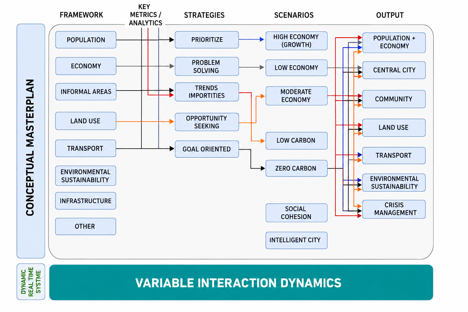
The Simulation Layer: In this stage, advanced algorithms, specifically Random Forest, are employed to simulate various “what-if” scenarios. This includes contrasting models, such as a Vision-Oriented Cultural City and a Carbon-Neutral Trend, enabling stakeholders to visualise potential outcomes under different urban development strategies (Veldkamp & Bouma, 2022).
-
The Publishing Layer: Similarly, this layer culminates in the creation of a real-time City Dashboard, designed to enhance transparency and accessibility for stakeholders and citizens alike. Fostering a participatory environment encourages a bottom-up approach to urban planning, allowing community input to play a vital role in decision-making processes (De Jong & Sijbesma, 2023).
Through these interlinked stages, the GeoAI framework facilitates variable interactions that are both logical and technical, driving the various phases of the master planning process. The processes and outputs include initiation, inception, formulation, evaluation, updating, monitoring, and public dissemination of the master plan. Artificial Intelligence and Deep Learning are pivotal in this process, enabling seamless integration with GIS-based planning and spatial modelling frameworks.
By showcasing strategic models and scenarios, the system encourages rapid adaptability, which can significantly influence the urban landscape. The diverse scenarios generated lead to varying city functionalities and typologies, such as a trend-modified carbon city, a vibrant economy-focused city, or a culturally rich, vision-oriented urban space. This holistic approach not only enhances urban management but also empowers communities to actively shape their environment (Figure [fig:variable-interactions]).
The development of a precise georeferenced spatial database for the city within a dynamic GeoAI framework facilitates timely and accurate data storage, updating, editing, utilisation, manipulation, scenario planning, and publishing across various platforms during the master plan formulation process. This includes plan updates, development tracking, and the dissemination of the master plan on the city's dashboard. Integrating city targets and Key Performance Indicators (KPIs) is essential in modern urban planning. These indicators are primarily based on established frameworks, such as ISO 37119, 37120, 37121, and 37122, as well as guidelines from the United Nations Sustainable Development Goals (UNSDGs), the World Trade Organisation (WTO), and the World Health Organisation (WHO).
Utilising these standards serves several crucial functions: first, as a means of measuring city performance; second, in the formulation of comprehensive master plans; and third, in the thorough evaluation of these plans. The ISO series, particularly ISO 37120, highlights indicators related to city services and quality of life, offering a universal benchmark for urban administrators (ISO, 2018). Meanwhile, the UNSDGs present a globally recognised agenda to promote sustainable and inclusive urban environments (United Nations, 2015). Together, these frameworks inform strategic planning processes, promoting a data-driven approach to urban development aligned with global best practices.
Practical applications of the proposed framework
The proposed GeoAI in this work is envisaged to have several applications. Its broad application is expected in national development planning. Countries typically formulate development plans regularly because existing plans cannot track and update changes as they happen. This framework seeks to provide a self-updating system without requiring reformulation of periodic plans. We present some specific aspects of national development plans to which this framework can be applicable (Figure [fig:practical-application]).
First, this framework can be applied to real-time infrastructure management, such as transportation networks. Cities that adopt GeoAI in their strategic planning can frequently and continuously monitor transportation networks to detect congestion patterns and high-risk locations that could create bottlenecks. This will enable near-real-time congestion management and seamless traffic flow. In addition, long-term adjustments are also possible. Therefore, this can serve the purpose of megacities and those suffering from traffic congestion.
Second, this framework can also monitor climate change and environmental incidents. Given the relevance of climate change adaptation and post-disaster action plans, this framework seamlessly tracks environmental metrics, including air quality, deforestation rates, and carbon emissions. Thus, city planners can monitor changes in environmental conditions and act accordingly. A case in point is Caulfield (2023), who reported that AI technologies have been deployed in California to predict wildfire risks.
Third, the GeoAI planning system is well-suited to address the unique challenges and opportunities of smart cities, enabling it to respond to real-time changes and developments. The GeoAI system integrates advanced technologies, including Geomatics, Artificial Intelligence (AI), and Deep Learning (DL), to continuously update city plans. Infrastructure, for instance, is one of the most tedious and laborious networks to manage and update (Figure [fig:dynamic-infrastructure]).
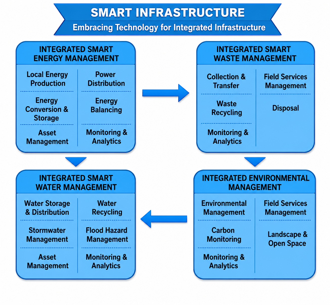
Finally, in addition to technological advancements, the GeoAI system emphasises the importance of stakeholder engagement and community involvement. By involving citizens in decision-making, smart cities can ensure that the master plan reflects the community's needs and preferences. This fosters a sense of ownership and improves the plan's overall effectiveness. Overall, the GeoAI planning system provides a comprehensive, dynamic framework for smart cities, enabling them to harness advanced technologies to create more efficient, sustainable, and livable urban environment.
Discussion
The discussion in this paper centres on the urgent need for urban planning systems to evolve from traditional static models to dynamic frameworks that can adapt to rapid changes in urban environments. Traditional master plans, which have typically been static and updated infrequently, often fail to capture the real-time dynamics of cities, resulting in misalignment between planned and actual land use. This paper argues for a transition towards a Dynamic Master Plan supported by a GeoAI-driven framework that leverages advanced technologies such as Geomatics, Artificial Intelligence (AI), and Deep Learning (DL).
The core argument posits that a “City Engine,” designed to be a live, updatable digital twin of urban environments, can greatly enhance urban governance by providing continual monitoring, evaluation, and publication of development strategies. By employing Convolutional Neural Networks (CNN) for automated change detection and GIS-based heuristic rules for plan versioning, the proposed system promises to streamline the planning process, allowing urban planners to quickly respond to changes and community needs.
Moreover, the importance of engaging citizens in the decision-making process is emphasised, ensuring that planning reflects the community's desires and requirements. By integrating AI-driven technologies, planners can also identify and prioritise projects more likely to succeed, thereby optimising resource allocation and enhancing community well-being.
The paper further highlights the global trend of using technologies such as GIS, satellite imagery, and AI to update master plans in real time, showcasing a shift toward innovative solutions tailored to regional challenges. By adopting a dynamic framework, cities can gain a more comprehensive understanding of development trajectories, enabling more informed decision-making and a more sustainable and responsive approach to urban development.
In conclusion, the paper argues that transitioning to a dynamic, live planning framework—where the master plan is viewed as an evolving body of knowledge—will significantly enhance urban planning outcomes, bridging the implementation gap and supporting sustainable regional growth amid rapid urban change.
Conclusions and Recommendations
This research presents a transformative approach to urban planning by advocating for the adoption of a Dynamic Master Planning System, supported by a GeoAI-driven framework. Traditional planning methods have proven inadequate in adapting to the rapid changes and complexities of modern urban environments, leading to gaps between planned and actual land use. In contrast, our proposed system leverages advanced technologies, including GIS, Artificial Intelligence, and Deep Learning, to create a living, real-time model of the city. This model not only adapts to evolving conditions but also supports informed decision-making by continuously monitoring and evaluating urban dynamics.
Our findings underscore the importance of integrating automated change detection and heuristic rules within a comprehensive city engine. By treating the master plan as a dynamic “body of knowledge,” we empower urban planners to respond swiftly to emerging trends, population shifts, and community needs. The participatory aspect of this approach also enhances citizen engagement, allowing residents to contribute to decision-making processes, ensuring that urban development projects align with their aspirations.
As this paper illustrates, the future of urban planning lies in frameworks that facilitate swift adaptability while maintaining a strategic long-term vision. By utilising cutting-edge technologies to monitor and analyse urban systems, cities can not only enhance administrative efficiency but also bolster sustainability and quality of life for their inhabitants. Ultimately, the Dynamic Master Planning System represents an essential evolution in urban governance, capable of bridging the implementation gap and paving the way for smarter, more resilient urban environments. As we move forward, collaboration among planners, technology experts, and communities will be vital to realising the full potential of this innovative approach, ensuring that cities are equipped to thrive amid ongoing change.
Conflict of Interest
Ethical Approval
Not applicable
Data Availability
The datasets used in this study are openly available at [repository link] and the source code is available on GitHub at [GitHub link].
Funding
This work did not receive any external funding.
References
Cite this article
Related Research


Special Issue
Launch a focused special issue to highlight research, emerging trends, and expert insights in your academic field.
