




IntelliPaper
Abstract
Almost 85% of the territory of South-western Bulgaria is occupied by mountains, including the Rila and the Pirin massifs - the highest mountains on the Balkan Peninsula, reaching almost 3000 m above sea level. It is logical to assume that the Struma River Valley, which is the largest in this region, was a natural conduit for the spread of the Neolithic lifestyle from the Eastern Mediterranean towards Central Europe. But was this the actual situation?
Only five settlements which have been dated to the various stages of the Early Neolithic Period have so far been registered in the Middle Struma Valley. The archaeological material from these sites reveals connections with the territories located to the south-west (northern Greece), to the west (Vardar River Valley) and to the east (Mesta River Valley). This indicates that the situation is much more complex, and the theory about the linear spreading of the agriculture from the south to the north along the Struma River Valley can no longer be regarded as proven.
During the entire Early Neolithic period all natural mountain passes connecting the valleys of the Struma River, the Bregalnitsa River, and subsequently of the Vardar River to the west and Mesta River to the east, were actively used as communication routes. Thus, it rather is the West-east and east-west axis that played major role for the connectivity of the region of the Struma River Valley during the Early Neolithic period.
Explore Digital Article Text
I. INTRODUCTION
According to most of the theories about the neolithization of South-eastern Europe (Gimbutas 1976; Garašanin 1979; Garašanin et al. 1971; Nikolov 1989, 1990a; Todorova, Vajsov 1993; Biagi et al. 2005; Brami, Heyd 2011; Krauss 2023, 83-97; Krauß et al. 2018; Ivanova et al. 2018), the valleys of large rivers occupy an important place as natural routes leading to the Danube Valley, and hence to the interior of the continent. The first theories ascribed a major role to the rivers Vardar, Bregalnitsa and Morava (Garašanin, Sanev, Simoska, Kitanoski 1971; Gimbutas 1976). Later, as the result of intensive archeological research in the western part of Bulgaria, the Struma, Iskar and Nishava rivers were likewise brought into the focus of the neolithization theory (Nikolov 1989, 1990a). After the discovery of the Early Neolithic settlement Eleshnitsa, the Mesta Valley also gained importance in this regard (Nikolov 1986; Nikolov 2003). The core argument is based on the similarities between certain cultural indicators registered in the Early Neolithic settlements in the valleys of the Mesta, Upper Maritsa, and Struma rivers and the Sofia Plain, with prototypes at certain sites in Anatolia such as Hacilar and Çatal Hüyük (Nikolov 1987; 1990a). According to Nikolov, the connection was made by sea, using natural sea currents (Nikolov 1989, Abb. 6; Nikolov 1990a, Abb. 7), and the places for establishing the settlements were precisely chosen near mineral springs (Nikolov 1990b). Other specialists concur that the movement was supposedly one-way from east to west, that the process itself was quite fast (Krauß et al. 2018), and the triggers for this movement were climatic (Weninger et al. 2014) and/or demographic (Bocquet-Appel et al. 2012).
With the accumulation of data, the complexity of the processes accompanying the spread of the new economy has been recognized (Furholt 2021; Leppard 2014; Leppard 2021; Reingruber 2011; Reingruber 2018). Attention is paid to the multi-layered nature of movements: large scale migration which is in general unidirectional from the east to the west and small scale movements, which are much more varied and complex and by no means unidirectional. This thesis was first proposed by Reingruber (2011): "The model of a wave of colonization sweeping over the Aegean as a whole must be rejected: that is, sites appear there at different stages in different landscapes". She notes a significant duration of this process, extending for about 1000 years and completed about 5500 BC (Reingruber 2011, 302). After Leppard (Leppard 2014, 487) "models which articulate several independent cultural and environmental processes appear more satisfactory, in terms of efficiency of explanation of data, than monocausal explanations".
Further Furholt (2021) also suggests that "it is necessary to study the different regional and local manifestations of Early Neolithic communities in their own right. And what might look as one single continental process is more likely an amalgam of several different processes, movements, and historic developments that took place at many different spatial and temporal scales".
In this context, it is crucial to restore small-scale migrations as a key to clarifying various aspects of the Neolithic process, also including genetic ones (Furholt 2021).
These observations find confirmation in the valley of the Struma River. Archaeological data from this region show that the situation was much more complex than the proposed models.
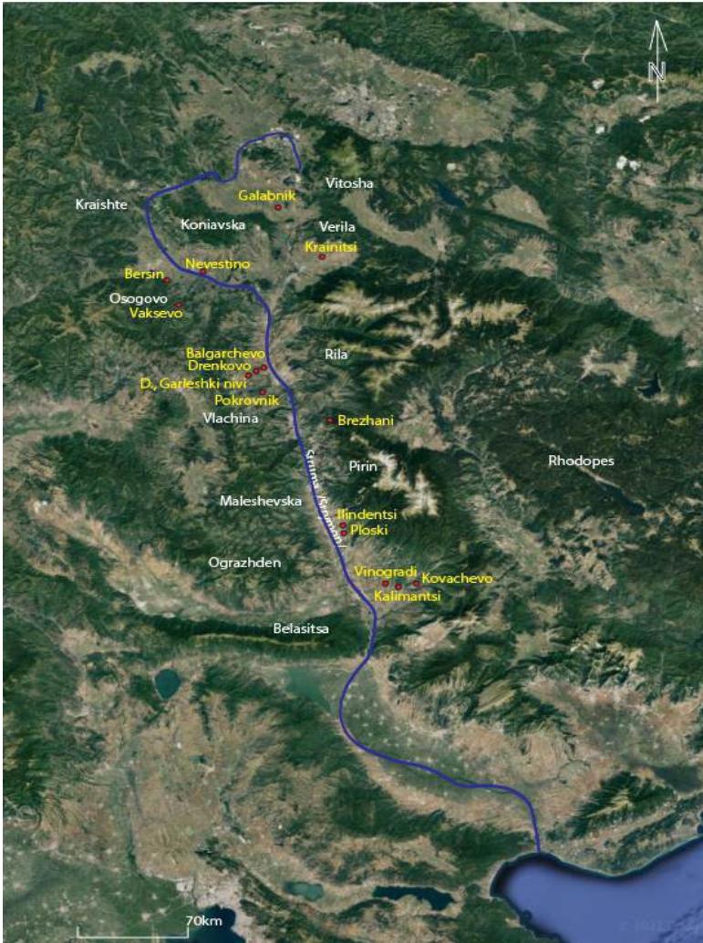
Already at the beginning of large-scale excavations in Kovachevo, doubts were expressed about the path of neolithization along the Struma Valley, and respectively another option was proposed (Lichardus-Itten 1993a; 1993b). As a result of intensive archeological excavations on the other Early Neolithic settlements in the Middle Struma Valley (Drenkovo, Brezhani and Ilindentsi) (Fig. 1), the database has increased significantly, and the overall picture has become much clearer. It concludes that the distribution of the Early Neolithic culture from south to north is difficult to prove, as there is no chronological and cultural cohesion between the Early Neolithic settlements. It became clear that the movements were diverse, stretched in time and carried out throughout the Early Neolithic period, i.e. between 6200 - 5450 cal. BC.
What were the criteria for establishing the settlements? What were the reasons for deciding to move and, most importantly, where did the first settlers from the Struma Valley come from?
II. BRIEF GEOGRAPHICAL CHARACTERISTICS OF THE STRUMA VALLEY
The Struma River flows through an extremely mountainous region, surrounded on the east by the Rila and Pirin mountains, the highest ranges in the Balkans, and by five mountain ranges to the west. The Struma springs from the southern slopes of Vitosha Mountain and flows into the Aegean Sea. The total length of the river is 415 km, and its valley is characterized by rhythmically repetitive valleys (7), separated by narrow gorges (8), formed by steep slopes of the surrounding mountains. The largest entity is the Sandanski-Petrich hilly valley in the southern part of the Middle Struma, and the longest is the Kresna Gorge extending over 16 km. It forms a serious climatic and ecological barrier between the Mediterranean and the continental zone. This natural boundary has always had a strong impact on the cultural development of the regions located to the south and north of that gorge (Grębska-Kulow 2013).
In such a mountainous region's passes, providing contacts with neighboring regions, to the west with the valley of Vardar River, and to the east with the valleys of Mesta and Maritsa rivers are of extreme importance.
2.1 Kovachevo - An Example of the Earliest Emergence of a New Economy and a New Lifestyle in the Struma Valley
Kovachevo is the first settlement in the Struma Valley, moving from south to north, and the earliest in the region (Pernitcheva 1990; Kulov, Kulov 1992; Lichardus-Itten, Demoule 1994; Lichardus-Itten et al. 2002). The chronological framework of the Early Neolithic settlements there is between 6210/6120 - 5450 cal. BC (Higham, Bronk Ramsey, Brock, Baker, & Ditchfield, 2011, pp. 1078–1079; Lichardus-Itten 2022; Lichardus-Itten, Demoule, Pernicheva, Grebska Kulova, & Kulov, 2006, pp. 85–86; Thissen & Reingruber, 2017).
This village offers several surprises and the first is its location. Kovachevo is situated 20 km to the east of the Struma Valley and is located on a small terrace of the river Pirinska Bistritsa - one of the tributaries of the Struma (Fig. 2). The place is sheltered, without very good visibility and definitely with a lack of optimal conditions for agricultural development. Nevertheless, it existed for about 1000 years without interruption throughout the Early Neolithic and Middle Neolithic, with traces of habitation in the Late Neolithic and Late Chalcolithic. A powerful settlement developed at the same place also during the Early Bronze Age, and later during the Iron Age (Kulov, Kulov 1992; Kulov 2011).
Why was this place chosen, how did the founders of this settlement get here and where did they come from?
Undoubtedly, its location was not accidental; rather it was highly strategic because it is here that two passes controlling the communication to the Mesta Valley to the east joined. One of them (Papazchair Pass) crosses the Pirin Mountains along the valley of Dobra Laka River, while the second one (Paril Pass) follows the Parilska Saddle and Kalimanska River. Many settlements along the Petrovska River, the Goleshovska River and the Kalimanska River, leading to this saddle, prove the exceptional importance of the Paril Pass. Settlements were founded during different phases of the Neolithic period and by various different groups of newcomers. At the end of the
Early Neolithic in the locality of Turski Dol, Kalimantsi village, where the Goleshovska River flows into the Pirinska Bistritsa, a settlement appeared with completely different ceramics in terms of manufacturing technology compared to Kovachevo (very deteriorated quality). During the Middle Neolithic there is a remarkable concentration of settlements. Apart from Kovachevo, along the valley of the Goleshovska River there is one settlement, and along the valley of the Petrovska River there are three more settlements. To these groups we must add a settlement in the locality of Marchin, the village of Katuntsi. Some of these settlements continued to exist in the Late Neolithic (Goleshovo, Vrisa), Petrovo, Beglika). These data prove the lasting interest and importance of the Paril Pass.
It seems that the main reason for this interest was the control of the flow of raw materials. Both roads lead to the neighboring valley of the Mesta and to the Rhodope Mountains. The earliest occupation phase in Kovachevo is characterized by the use of dark flint, originating in the Rhodopes (Nachev 2009; Gurova 2018). Hence the two passes were instrumental for the procurement of such raw material, extremely important for the normal existence of the settlement. Another important raw material is nephrite. In Kovachevo there are a large number of objects made of this semi-precious stone, not only ornaments, but also tools: axes and adzes (Kostov, Machev 2008; Kostov et al. 2017; Grębska-Kulow, Kulov, Kostov 2023). Nephrite was a very important raw material for the Early Neolithic inhabitants not only in the region in question but throughout the Balkan Peninsula. So far, nephrite deposits have been documented only in Ograzhden Mountain across the Struma River (Zidarov, Kostov, Zidarov 2010). In recent years near the Paril Saddle in the valley of the Maritsa River, a right tributary of the Mesta, in the lands belonging to the village of Koprivlen, an area potentially promising for the presence of nephrite deposits has been discovered. This assumption is reinforced by the fact that a small, untreated piece of nephrite was found in the Late Chalcolithic settlement of Ilinden.
The first settlers in Kovachevo probably came from the Northern Greece (Lichardus et al. 2006; Lichardus-Itten 2009) based on remarkable similarities in white painted ornamentation, as well as anthropomorphic figurines and altars (Grębska-Kulow, Zidarov 2021). It is not possible to name only one settlement in Northern Greece with very similar parameters, which could be a starting point for migrants, but several sites such as Giannitsa, Axos, Nea Nikomedeia, Mavropigi could be connected with Kovachevo through various elements. A significant difference between these sites however is marked by a break in the supply of raw materials. For example, notwithstanding the large extent of the excavated area, not a single fragment of obsidian was found in Kovachevo, confirming the observation that it was situated beyond the northern limit of use and exchange of this raw material, originating from the island of Melos and reaching some sites in Northern Greece (Reingruber 2018). The population of Kovachevo certainly needed a substitute for this raw material, and the Rhodope Mountains provided them with dark, good quality flint, furthermore the Rhodope flint resembled obsidian in color. The settlement maintained contacts with the area of origin also in the later phases, which is indicated by the appearance of an askoid form of vessel - in the phase Kovachevo Ib together with some curious clay objects with a rectangular shape, slightly convex on the sides with unclear purpose (Fig. 3. 1,4,5). Similar objects have been found so far also in Lete I, Northern Greece (Fig. 3. 2), as well as in Damjan, the Republic of North Macedonia (Fig. 3.3). This indicates that the settlements from the fast territory of Northern Greece, eastern part of North Macedonia and South-western Bulgaria were in constant contact with each other.
There are two possible routes for penetration from the south to this part of the Struma Valley: one is along the Lower Struma and through the Rupel Gorge, the other along the Vardar River, and the Strumeshnitsa River, a right tributary of the Struma (Fig. 10). We have no conclusive evidence for any of these routes, but in no case can the second possibility be eliminated along the west-east axis, for which we have indirect argument: the Early Neolithic settlements in Northern Greece with close material culture (Nea Nikomedia, Giannitsa B, Axos) are located either in the valley of Vardar/Axios or near this region. It is quite possible that the route of the first settlers who appeared in Middle Struma passed along the Vardar, the valley of Strumeshnitsa and crossing the Struma, continued to the east along the valley of the Pirinska Bistritsa.
Kovachevo Ia shows close similarities with Pelagonian settlements not only through the motifs of white painted pottery (Lichardus-Itten et al. 2002, 130), but especially through the quadrangular cult tables with stairs-like legs (Grębska-Kulow 2011; Grębska-Kulow, Zidarov 2021, Fig. 4/2,3,5,6). The two regions show remarkable synchronicity in cultural development throughout the Early Neolithic, suggesting the maintenance of intensive contacts between them. These similarities are suggestive that the main conduit of contact followed the Strumeshnitsa Valley from the west, as the most direct link between the two regions.
During a later stage of the Early Neolithic (5900/5800 BC), the Karanovo I culture which developed to the east in Thracian Plain, Mesta and Maritsa valleys, penetrated into the Sandanski-Petrich Valley, most probably through the two passes, Papaz Chair and Paril, and became part of the material culture of Kovachevo Ic and Id (Lichardus-Itten et al. 2002, 128). Apart from the typical Karanovo I white painted motifs, also anthropomorphic figurines with a flat torso (Lichardus et al. 2002, 158 Pl. 22. 9, 10; Lichardus 2017) and "Karanovo type" blades made of so-called "Balkan flint" (Gurova 2008; 2018) appear. The cult tables remain quadrangular, but with a new stabs and chequerboard like decoration (Grębska-Kulow, Zidarov 2021, Fig.
4.7, 8, 9), which is characteristic for Karanovo I culture. That is why Nikolov defines this cultural phenomenon as the south-western variant of Karanovo I culture (Nikolov 1996).
The next Early Neolithic settlement in the region is Ilindentsi (Grębska-Kulow et al. 2011; Grębska-Kulow, Zidarov 2020; Grębska-Kulow, Gurova, Zidarov 2021). The settlement was founded in the second half of the Early Neolithic, about 5900/5800 BC and is located about 35 km in a straight line from Kovachevo. It is located in the valley of the Struma River on its left side, on a high terrace at an altitude of 250 m at the foot of the Pirin Mountains (Fig. 4). There are remarkable similarities between Ilindentsi and Kovachevo in terms of architecture, construction of ditch and ceramics, which suggest that it was founded by a group of people who likely departed from Kovachevo in the period of its greatest development - Kovachevo Ic.
Why this place? The answer is clear if we take into account the geographical features and raw materials. The village has perfect visual control over the Struma Valley. Furthermore, there are large deposits of marble in the surrounding Pirin Mountains, the raw material used to make jewelry and household items. To the west, in the Maleshevo Mountains near Ilindentsi, there are deposits of flint with pigeon-grey color, widely used in Ilindentsi, and we should not forget the nephrite deposits in the neighboring Ograzhden Mountains, (Zidarov, Kostov, Zidarov 2010). There is another very important factor – opposite the village there is the starting point of the road along the valley of the Tsaparevska River leading to the valley of the Bregalnitsa, and from there to the Vardar Valley. Contacts with this region are indisputable, confirmed by a specific abstract-floral style in white painted pottery (Grębska-Kulow, Zidarov 2020) and a type of idols with horn-like projections that originated in Northern Greece and spread to Pelagonia (Grębska-Kulow, Gurova, Zidarov 2021).
Contact with the south (Northern Greece) was maintained by the inhabitants of the village and this is evidenced by the presence of spondylus shells in the form of jewelry and raw materials, as well as architecture with stone foundations of walls typical of the southern Balkans (Grębska-Kulow, Zidarov 2020). In Ilindentsi there are also clearly expressed elements of Karanovo I culture in the form of Karanovo style white painted ceramics (Grębska-Kulow, Zidarov 2020) and Karanovo type blades made of Balkan flint (Gurova 2018, 117-120). It has not been proven whether they appeared as a result of direct contacts with the Karanovo I cultural area or through transmission by Kovachevo, which is more probable. The strategic importance of the area is underlined by the fact that another prehistoric settlement was registered close by in the outskirts of the village of Ploski. There the excavators found ceramic fragments with red slip as well as black polished pottery. These define the chronological framework of this settlement to the Early and Middle Neolithic. Unfortunately, the settlement is almost completely destroyed by erosion.
Three more Early Neolithic settlements—Brezhani, Drenkovo and Balgarchevo – are situated to the north of the Kresna Gorge in the northern part of the Middle Struma catchment.
Brezhani is located at the northern foot of Pirin at 650 m above sea level (Fig. 5), on a high terrace of the Brezhanska River (Grebska-Kulova, Kulov 2010; Grębska-Kulow 2017, 253). The village is established around 5900 cal. BC and located at the exit/entrance of the Kresna Gorge, but tucked away in the mountains. Here, too, the place for the settlement was carefully chosen, to control passages leading to the southern part of the Struma over the Kresna Gorge, to the east through the Predel Pass to the Mesta Valley, and it is possible that there was also a road leading to the west, to the Bregalnitsa River Valley and further to the west to the Vardar River Valley. The village is located near the so-called "wine road", known in the 19th century, which connected Melnik, a center of wine production in the Struma Valley, with the mountain town of Bansko in the valley of the Mesta River (Grębska-Kulow 2013). It is quite possible that it succeeded an earlier route from prehistoric times, but it was never an important factor in communication between the southern and northern parts of the Struma Valley. This is evidenced by the great differences in material culture between the two regions in all periods, including the Early Neolithic period. The two Early Neolithic settlements Ilindentsi and Brezhani existed at the same time, and are located on the opposite sides of the Kresna Gorge, but present quite different characteristics in their material culture. At Brezhani, the ceramics is less diverse in terms of ornamentation, as only white painting is present. In terms of stylistic influences, it shows two directions; one is the Karanovo or Thracian style, and the second is the solid abstract style developed in Northern Greece and the RNM (Grębska-Kulow, Zidarov, 2021). Relations with Karanovo I culture are also strengthened by the presence of Balkan flint blades, anthropomorphic figurines with a flat torso, and triangular cult tables with a chequerboard pattern (Grębska-Kulow, Zidarov, 2021, Fig. 3.8; 4.11). We can assume that the contact with the valley of the Mesta was maintained through the Predel Saddle. It should be noted that this is the only settlement with clear elements of Karanovo I culture, north of the Kresna Gorge. In contrast, the second group of painted pottery shows clear connections with the north, with the Galabnik group in Upper Struma. These are specific motifs in painted ceramics, biconical shapes, three-part pedestals, characteristic round depressions on the inside of the bottom, etc. Here we must add a unique vessel with three walls and incised decoration of wide grooves forming meanders. It is very close in form to a specific group of cult tables from Galabnik, group F1 (Fig. 6). This is the period when the Starčevo culture became dominant in the Upper Struma Valley and we can assume that as a consequence, a group of locals from the area of Galabnik group, forcibly or voluntarily moved south and settled in Brezhani.
The next Early Neolithic settlement as one looks to the north is Drenkovo I, Ploshteko, located on the northern outskirts of the Middle Struma. It is the second, after Kovachevo in the Middle Struma Valley settlement established quite early, around 6200 cal. BC. Drenkovo is located 13 km west of the Blagoevgrad Plain in the foothills of Vlachina Mountain, on the first terrace of the Drenkovo
River with an altitude of 550 m (Grebska-Kulova, Kulov 2004; Grębska-Kulow 2017, 253-254). It is situated on the road connecting the valleys of the Struma and Bregalnitsa through Delchevski Pass. On the opposite site of the river there is another prehistoric settlement from the end of the Early Neolithic - Drenkovo II, Garleshki nivi (Stojanova-Serafimova 1970). A few hundred meters to the north along the Drenkovska river there is another prehistoric settlement (Drenkovo, Desetoko) dated to the Middle Neolithic, and to the south a settlement from the end of the Late Neolithic (Logodazh, Berova kitka) (Grebska-Kulova 2009, Fig. 1) (Fig. 7). This concentration of settlements, exactly in the area where Drenkovo I is located is not random since the valley of the Drenkovska River, surrounding the narrow Skrinski Pass connects the Upper Struma and the vast Kyustendil Plain. This road was in active use until the end of the 19 century, as evidenced by a large concentration of archaeological sites, including a stone building type known as a "Kaimenska Chuka" from the Late Bronze Age and a road station (quadriburg) from Roman times (Grebska-Kulova 2009). It should be noted that on the opposite site of the northern ridge, in the valley of the river Eleshnitsa, a tributary of the Struma, two other Early Neolithic settlements – Vaksevo and Nevestino – with similar characteristics are located (Čohadžiev, Genadieva 1998). The typical white painted pottery is registered, and almost no other types of decoration except for one fragment with a classic barbotine technique, one fragment with a plastic ribbon and "bird's eye" impressions, and channeling is completely absent. White painted motifs are very simple and represent thin straight lines, garlands, triangles densely filled with paint or triangles filled with net and abstract-floral motifs (Grębska-Kulow 2017, 253-254). Regarding the forms, the motifs, and its anthropomorphic figurines (Grębska-Kulow, Zidarov 2021, Fig. 3. 2, 10, 12), Drenkovo I finds its closest parallels in Anzabegovo I in the valley of the Bregalnitsa (valley of the river Vardar) and one can suppose that the first settlers came from the area of this culture. Comparing this material with Kovachevo, we must note that in terms of line thickness and the dominant percentage of undecorated surface this pottery reminds Kovachevo Ia, and in terms of some of the motifs (net-filled triangles) – the phase Kovachevo Ib. The connection with this phase is also confirmed by a ladder-shaped fragment of a cult table (Grębska-Kulow, Zidarov 2021, Fig. 4.19). In Drenkovo I we have no traces of Karanovo I culture features.
Balgarchevo is the last settlement in the Middle Struma Valley that emerged during the Early Neolithic and the only settlement in the region of South-western Bulgaria with continuous development from the Early Neolithic to the Late Chalcolithic, i.e. ca. 1500 years of continuous development, followed by occupation during the Late Bronze Age and Antiquity (Pernicheva-Perets, Grębska-Kulow, Kulov 2011). This testifies to its exceptional role as a central settlement in a network of prehistoric settlements in the region. It is located at the end of the Blagoevgrad Plain, on a high terrace above the Struma, overlooking Byalopol Gorge, and the starting point of the road leading to Delchevski Pass (Fig. 8). On the other side of the Struma the road begins which connect this region with the valley of the Mesta River, through the Valley of the Bistritsa River and a high mountain pass of Rila. This road certainly existed in antiquity, as evidenced by several Late Antique fortresses, but most likely also in the earlier periods as indicated by the traces of prehistoric settlements. It is interesting to note that on the opposite side of this pass, located at 1000 m above sea level, is the Early Neolithic settlement of Belitsa (Pernicheva 1990), which is definitely directly related to this pass.
There is no separate layer with white painted ceramics at Balgarchevo, and white painted fragments are mixed with dark painted ones from the very start of the layer Balgarchevo I (Pernicheva-Perets, Grębska-Kulow, Kulov 2011, 118-134). Here, too, in terms of style there are no motifs or compositional combinations characteristic for the Karanovo I culture. The white motifs are abstract-floral and to some extent are similar to the dark painted type. Close parallels are found in the settlements of Rug Bair in the region of Ovče Pole and Zelenikovo I in North Macedonia, but also with the rather remote settlement of
Golokut in Banat (Pernicheva-Perets, Grębska-Kulow, Kulov 2011, 209). This surprising proximity might be explained in the context of changes registered in the Struma Valley at the end of the Early Neolithic and the emergence of a new population from the area populated by communities of the Starčevo culture. These groups brought with them pottery made with a rather primitive manufacturing technique, new forms, and new painting style characterized by dark, liquid paint placed on a non-contrasting surface: gray, dark gray or brown. Several new settlements are closely related to this phenomenon: Drenkovo II, Garleshki nivi, Pokrovnik, Vinogradi, Kalimantsi (Fig. 1), but such pottery is registered in Balgarchevo (Pernicheva-Perets, Grębska-Kulow, Kulov 2011, 209), Ilindentsi (Grębska-Kulow, Zidarov 2020, Fig. 19. 9,12) and Kovachevo as well (Fig.9).
2.2 Stages of Neolithization in the Struma River Valley During the Early Neolithic Period
The presented archeological data show that the introduction of agriculture and neolithization in the valley of the Struma River, South-western Bulgaria, was a lengthy process extending for about 700 years throughout the whole period of the Early Neolithic, i.e. from 6200 to 5500/5450 BC. It has different intensities in different sub-geographical regions, very rarely develops along the south-north axis, and mainly along the west-east trajectory. It is important to note that there were also movements from north to south and from east to west. Several stages of colonization can be distinguished:
-
Stage 1 (6200-6000 BC). During the first stage two settlements appeared: Kovachevo and Drenkovo I. They are 120 km away and represent rather different origins. Kovachevo Ia, shows clear connections with settlements in Northern Greece, Thessaly and Pelagonia. Drenkovo I also shows connections with Northern Greece but also with the settlements of Pelagonia and Ovche Pole in the Vardar Valley.
-
Stage 2 (6000-5900 BC). The settlements established at the beginning of the VI millennium BC are concentrated in the Upper
Struma and belong to the Galabnik and Nevestino groups. In Kovachevo develops phase Ib with the new style of whited pottery and motifs like ladder and triangles filled with net, as also in Drenkovo I.
-
Stage 3 (5900 - 5700 BC). During the third stage of the Early Neolithic, contacts along the Struma River were much more intensive and diverse. Two settlements appeared in the valley of the Middle Struma, on the opposite sides of Kresna Pass: Ilindentsi and Brezhani. Both settlements are the result of movements of people in the valley of the Struma from the south (Ilindentsi) and from the north (Brezhani). Archaeological data from Ilindentsi show a clear connection with Kovachevo Ic and it is quite probable that the settlement was founded by a group of people originating from this settlement. The reason for the opposite migration, from north to south and the foundation of Brezhani may be related to the emergence of a new population in the Upper Struma Valley related to the Starčevo culture. It could be assumed that tensions between the two groups – the Galabnik group and Starčevo culture forced some people to search for new territories for colonization. During this stage, contacts with regions to the east – the valleys of Mesta and Maritsa that were part of the area of Karanovo I culture are best represented in Kovachevo Ic and at Ilindentsi, as well as at Brezhani to the north. However, there are no indications whatsoever that the Karanovo I culture has ever entered the Blagoevgrad Plain as well the Upper Struma Valley. At the end of this stage Balgarchevo was established with white painted pottery but also very strong elements of Starčevo culture. This settlement forms the south-eastern border of this culture.
-
Stage 4: around 5500/5450 BC. At the very end of the Early Neolithic in the Middle Struma Valley, new settlements with a completely different material culture appeared. These are Drenkovo II, Garleshki nivi, Pokrovnik, Vinogradi and Kalimantsi. These settlements are characterized by pottery of very poor quality in terms of technology and decoration if compared to local Early Neolithic pottery. The fact that all these settlements are established on previously uninhabited places, points to the conclusion of a new population - groups of people from the north, northwest, from the territory of Starčevo culture and is associated with the last stage of its existence. In this period a significant degeneration of the Starčevo culture has also been noted in other regions (Šošić Klindžić, Hršak 2014, 19). It should be noted that similar ceramics were found in Balgarchevo, Kovachevo and Ilindentsi (Fig. 9), which shows the considerable extent of this process.
III. MOTIVES OF MOVEMENTS (PUSH AND PULL FACTORS).
When looking for reasons for the movement of people in the Early Neolithic, two factors are most often cited: demographic growth as a result of a new, more efficient economy (Bocquet-Appel et al. 2012), and climate changes (Weninger et al. 2014).
The situation is different in micro-regional movements, where the reasons can be more diverse and each case should be considered individually (Reingruber 2018, 15). Leppard points to several potential causes of human movement (avoiding conflict, disease, impoverishment), but accentuated to the social and economic aspects and tensions that can arise as a result of processes caused by storage and division of agricultural surplus (Leppard 2014, 490; Leppard 2018).
Data from the Struma Valley contribute to this issue. Movements registered in the Middle Struma Valley confirm the thesis of various factors in micro-regional movements and the need for site-specific approach to bring some clarity. Reasons for dislocation can be determined with a high degree of certainty at least in two of the presented examples.
The first case is movement from Kovachevo to Ilindentsi around 5900 BC. This migration is directly related to the significant growth of the settlement in the Kovachevo Ic period as a result of population increase. Demographic growth of around 5900 BC is a large-scale phenomenon observed not only in the Balkans, but also in the broad context covering the whole of South-eastern Europe, including the Great Hungarian Plain (Blagoević et al. 2017). In another case - Brezhani, we can assume with high probability the reasons that led to migration of groups of people from the north to the south - related to the meeting/clash of two different cultures (the Galabnik group and Starčevo culture) and respectively two different populations (ethnicities), the intolerance between them seemingly led to leaving and searching for new places to live. It also explains the direction of movement from north to south – opposite to the main vector of the neolithization process.
The reasons for the appearance of a new population at the end of the Early Neolithic in the valley of the Struma River one must seek in processes that took place in the area of Starčevo culture presence at the end of its existence. Most likely, there was social tension and expansion to the south.
The case of Kovachevo is also interesting, which at this stage we tend to associate with the procurement of suitable raw materials, in the case of flint, which would compensate for the lack of obsidian. It seems that Rhodope flint met the requirements. Introducing a new economy is a side effect of meeting these needs.
3.1 Mountain Passes - The Key to Early Neolithic Settlement in the Middle Struma Region
Most Early Neolithic settlements in the Struma Valley are far from the river valley itself, located in mountainous or sub-mountainous regions. The one thing they have in common is the proximity to mountain passes. It seems that the mountain passes leading to the west and to the east were extremely important for Early Neolithic inhabitants, and the desire to control them was one of the leading in choosing the exact place for settlement. This fact explains the small number of Early Neolithic settlements in the Middle Struma Valley itself, the region was not of interest for the development of sustainable agriculture, but was important in terms of control of communication routes and access to raw materials.
The settlements (Kovachevo and Brezhani) are located in mountainous regions with limited opportunities for the development of agriculture on a larger scale. In addition, Brezhani is located at an altitude of 620 m above sea level where the vegetation cycle is significantly reduced. A similar case is with the village of Belitsa located in the Rila Mountains at 1000 m above the Mesta River (Pernicheva 1990).
The reasons for the formation of a settlement at Kovachevo must have been related to the desire to control the two passes known as Papaz Chair and Paril leading eastwards to the valley of the Mesta and the Rhodopes, and respectively to control the flow of various raw materials, without which the Early Neolithic settlements could not function properly.
Brezhani is located at the crossroads between the valleys of the three great rivers which was of exceptional importance.
Ilindentsi, despite being one of the few settlements located in the Struma Valley, is associated with the control of the road leading to the west, to the valley of the Bregalnitsa River through Klepalo Pass. In addition, flint deposits have been discovered in the Maleshevska Mountains, and nephrite deposits have been discovered in the neighboring Ograzhden Mountains. Drenkovo is also located in an extremely important place, on the road along the Logodashka River, which through Delchevski Pass leads to the west to the valley of the Bregalnitsa and Vardar rivers, and to the east to the valley of the Struma. Exactly at this place the road branches off and along the valley of the Drenkovska River leads directly to the Kyustendil Plain in the Upper Struma, bypassing the difficult traverse through the Skrinski Pass.
Balgarchevo has excellent visual control over the entire Blagoevgrad Plain, and controlled the Byalopolski Pass - the northern exit from the plain. Nearby begins the road to Bregalnitsa and on the opposite side of the plain, a high mountain road begins leading to the Mesta Valley and the Razlog Plain.
In the Upper Struma Valley, the settlements of Vaksevo and Bersin are also located in strategic places: Vaksevo controlled one road along the Eleshnitsa River and the Cherna Skala Pass and Bersin is located near the pass of the Kriva Palanka, both leading to the Vardar Valley.
It seems that the control over the passes was an extremely important factor in the foundation of the Early Neolithic settlements in the Struma Valley. This conclusion leads to other considerations.
3.2 Early Neolithic Avant-Garde, Mesolithic Substrate or both Together?
The places for settlement were very precisely chosen, with a feeling of very good knowledge of the region in terms of topography but also raw materials. This, in turn, presupposes the existence of a stage of preliminary study of the region. The existence of this stage in the process of neolithization is fiercely discussed in relation to other regions of the Balkans (Leppard 2014; Reingruber 2018). This "model" fits very well into the nature of contacts between the region of Northern Greece and the southern part of the Middle Struma Valley - a new goal for settlement in the late VII millennium BC. Here, a stage of preliminary research lasted about 100/150 years, if we take into account absolute dates from both regions.
Kovachevo in the earliest stage of existence, i.e. 6200 BC has no direct successors either in the Struma Valley to the north or in the entire Balkan Peninsula, i.e. similar as motifs are white painted pottery, anthropomorphic figurines with characteristic cocoons, or small rectangular cult tables with a profiled edge of the receptacle are not evidenced elsewhere until now. During this stage it was aimed at maintaining contacts with the core region of Northern Greece and it is proved in the emergence in the Kovachevo Ib period of a completely new form (askos), new techniques in painting (ton sur ton) and specific objects with unknown function, which so far have been registered just in three villages Lete, Damjan and Kovachevo.
Another possible scenario, or rather a supplement to the first, is contact with the local Mesolithic population, well acquainted with the terrain and the location of the necessary raw materials for the normal existence of a settlement. More and more attention is paid to the role of the local population in the Neolithic processes within the Balkans (Thissen 2009, Antonović, Stojanović 2009, Mihalić 2009). Indirect arguments in favor of this thesis based on a similar concept of ornaments and in particular rings with horn-shaped growths (Antonović, Stojanović 2009) and/or ceramic production appeared in the Danube Valley at the end of the 7th and beginning of the 6th millennium BC without clear Anatolian know-how applied in its technology (Thissen 2009).
There is positive evidence for the existence of a local population in the territory of present-day Greece (Kaczanowska; Kozlowski 2015). The neolithization of the East Aegean Coast is the result of constant contact between local groups of hunters, gatherers and fishermen who were proficient in shipping and use obsidian from Melos and farmers who came from Anatolia (Reingruber 2018, 5; Leppard 2021). The process of mutual filtration in the Aegean was long, and the mobility was multidirectional.
The data regarding the Mesolithic population from the territory of present-day Bulgaria are more than scarce (Gurova, Bonsall 2014a, 108-111; Gurova, Bonsall 2014b). No site has been registered, only materials from the Pobiti Kamuni near Varna typologically may or may not correspond to this period. For the existence of Mesolithic population from this era we have indirect evidence based on genetic research from Malak Preslavets (Furholt 2021 and discussion).
A difference of 100/150 years between settlements originating in Northern Greece and the first northern settlement near Kovachevo could be interpreted as a period of mutual contacts and cooperation and exchange between agricultural societies and presumed local Mesolithic groups, the same scenarios as proposed for the other parts of the Aegean (Reingruber 2018, 10-11).
Indirect arguments lead to the conclusion that it is quite possible that there was such a population here. Conditions for the development of this type of activity were excellent, with large areas covered with forest and wildlife and a great wealth of plants. Mobility of these groups of gatherers and hunters leads to an excellent exploration of the terrain with all possible natural passages. One of the arguments in favor of this thesis is excellent knowledge of local raw materials and mainly Rhodope flint, as well as the presence in Kovachevo, albeit in small quantities, of microliths (Demoule 2009), which also echo the older, Mesolithic traditions.
Another argument is that this territory is surrounded by Mesolithic sites in Greece and Albania, so why not in the region under discussion?
IV. CONCLUSIONS
The process of neolithization of the Struma River Valley was complex, diverse, and extended in time. Linear development of the Early Neolithic settlements along the Struma River Valley, from south to north is not convincingly supported by the available data. There is only one evidence for south-north movement and that is between Kovachevo and Ilindentsi in the later stage of the Early Neolithic. Movements from west/southwest to east were more important. Undoubtedly, the first farmers came from the west/south-west and entered almost simultaneously the Middle and Upper Struma River Valley. Contacts with the west were very important for this region throughout the entire Early Neolithic. At the same time, settlements such as Kovachevo and Brezhani were oriented towards the east and controlled all the Struma passes leading to the east, to the valley of the Mesta and the Rhodopes, a source of vital raw materials.
Motives leading to the choice of places for settlement were the control over the passes leading to the neighboring valleys on both sides of the Struma. This applies to all settlements in the Middle Struma Valley. The second motive was the provision of raw materials, mainly flint, and other rocks used to make tools, ornaments and amulets.
Excellent knowledge of the geographical features of the region implies the existence of a stage of preliminary study of the region followed by a precise choice of place for settlement. On the other hand, the existence of a local population (Mesolithic) with excellent knowledge of the region, who also participated in this process, should not be ruled out. This assumption is based on indirect evidence and only genetic testing of human remains from the Struma settlements can confirm or refute this thesis.
ACKNOWLEDGEMENTS
The author extends the gratitude to Shelby White – Leon Levy Programe for Archaeological Publications for the financial support of the project "The Neolithic sites Brezhani, Drenkovo I, and Drenkovo II, South-western Bulgaria" in frame of which C14 dates for Brezhani and Drenkovo have been made. Also her thanks go to dr Nadezhda Todorova for sharing unpublished information from Ilinden and first results of the project "Hidden deposits and known finds. The Geoarchaeological Survey in the Maritsa River Valley, Southwestern Bulgaria". The author is exceptionally grateful to English language editor, Dr Orlene Mcilfatrick, for her assistance with the final text.
0 6 cm
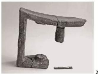
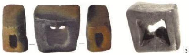
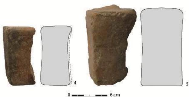
Figure 3: Undetermined finds registered in: 1, 4, 5. Kovachevo (scale 1:2);
-
Lete I (Pappa, Tzanavari 2013, Fig. 11);
-
Damjan (Stojanova-Kanzurova 2017, Fig. 8) (scale 1:3)
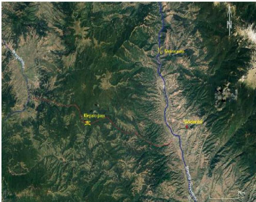
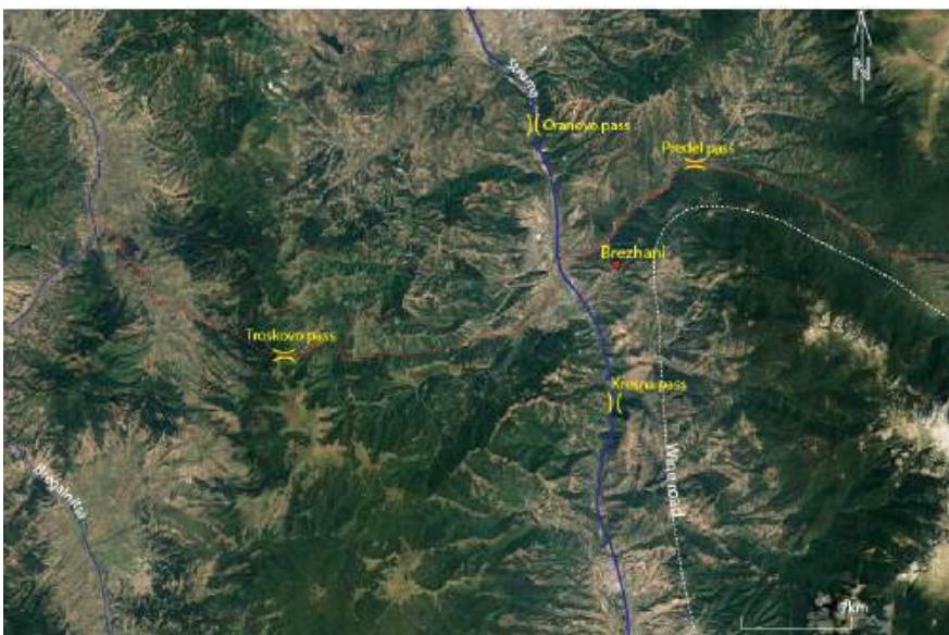
Figure 4: Ilindentsi settlement and Klepalo Pass
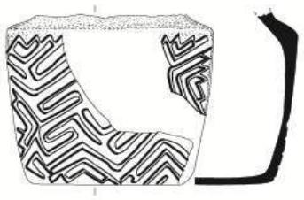
Figure 5: Brezhani settlement and surrounding passes
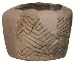
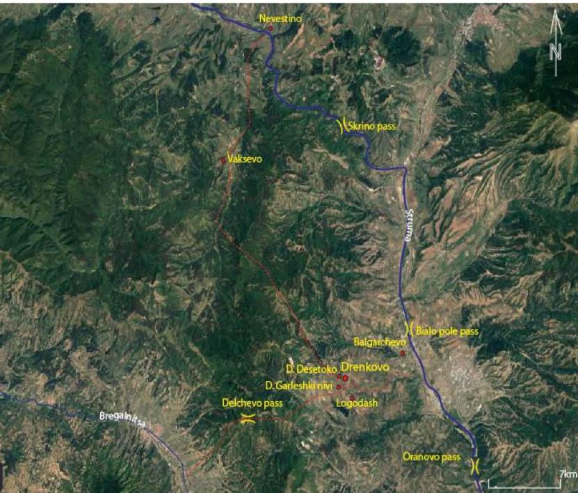
Figure 7: Drenkovo settlement and Delchevo Pass
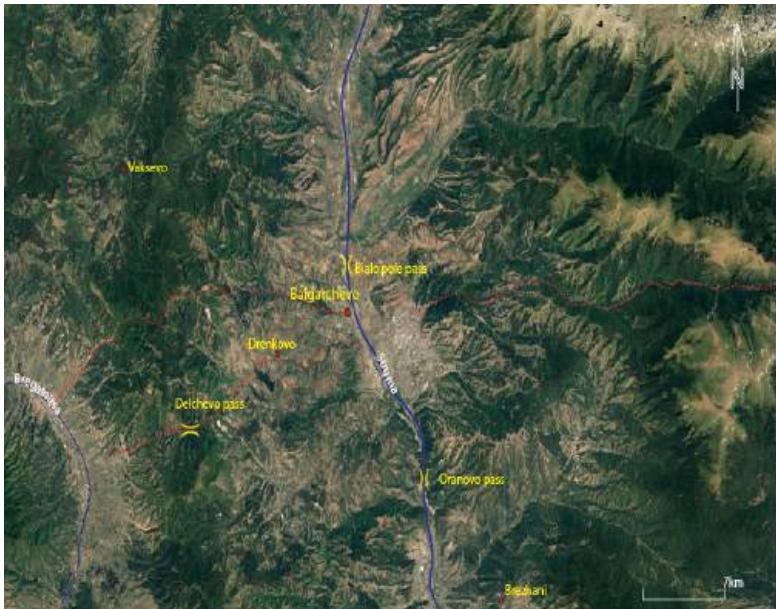
Figure 8: Balgarchevo settlement and surrounding passes
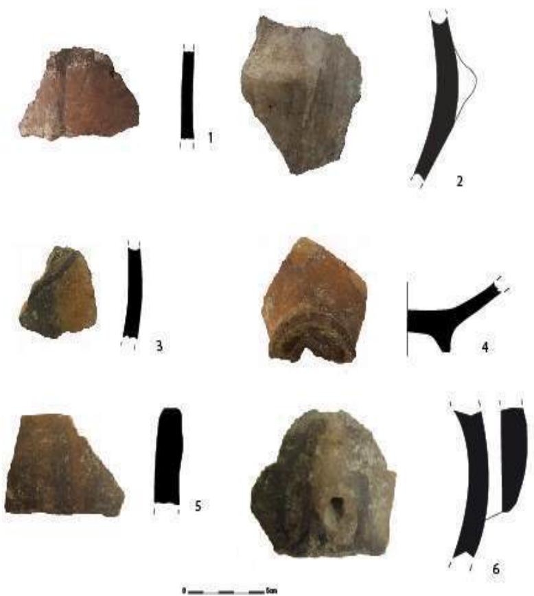
Figure 9: Painted pottery from the end of the Early Neolithic. 1,2 Balgarchevo; 3,4 Ilindentsi; 5,6 Kovachevo
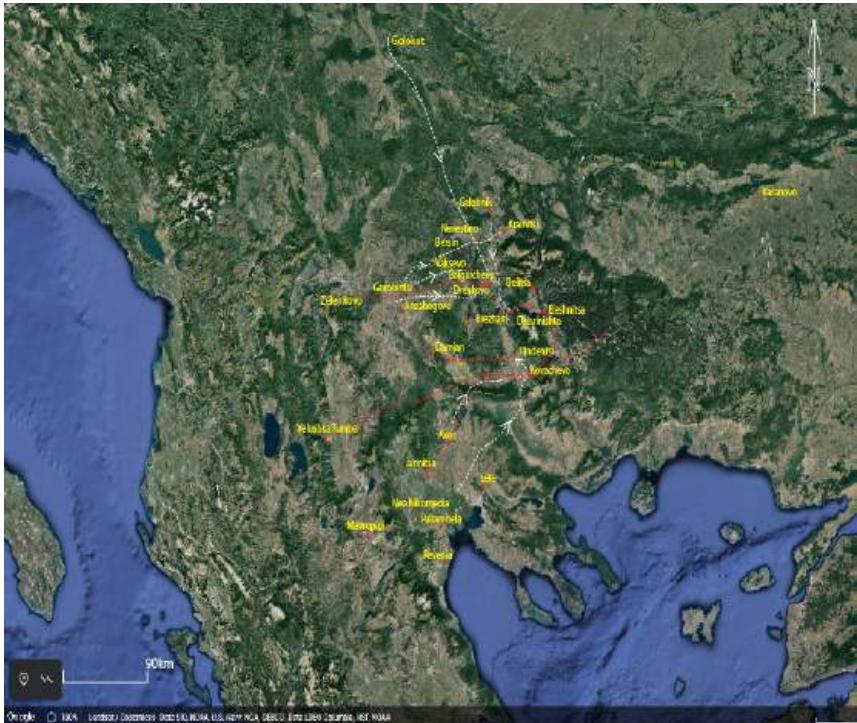 Figure 10: Routes of neolithisation /colonisation (white dash lines) and contacts (red dash lines) during the Early Neolithic period in the Struma Valley and adjacent regions
Conflict of Interest
The authors declare no conflict of interest.
Ethical Approval
Not applicable
Data Availability
The datasets used in this study are openly available at [repository link] and the source code is available on GitHub at [GitHub link].
Funding
This work did not receive any external funding.
References
Cite this article
Related Research



Special Issue
Launch a focused special issue to highlight research, emerging trends, and expert insights in your academic field.
