


IntelliPaper
Abstract
The question of demining sea raids and ports, which is relevant for Europe in the period of active deployment of military confrontations on its territory, is considered. It is proposed to combine the search capabilities of unmanned aerial vehicles (UAV) with the ability of trawler boats to clear floating mines. The optimal trajectory of search movements of UAV along the Archimedean spiral is proposed. An appropriate number of UAV that can effectively search for floating mines simultaneously is determined.
Mine detonation with warheads dropped from an aerial liquidator drone is proposed as one of the most effective ways of the disposal of mines.
The proposed method can be used to manage the search movements of UAV, to process the data provided by them about the detected floating mine, and to clarify the coordinates of the floating mine. A corresponding block diagram for computer software is proposed.
It has been established that using the proposed search method and at the speed of UAV 5-5.5 m/s, it is possible to survey up to 6 square kilometers of sea every hour. At the same time, it is possible to save up to 20 liters of fuel for the trawler boat.
Explore Digital Article Text
I. INTRODUCTION
It should be noted that during the last decades, due to the use of state-of-the-art computer technologies at the stage of design and calculations, huge progress has been made in the improvement of military equipment. Besides, the main trend in almost all areas of building military equipment and weapons is minimization of human participation in setting up and using weapons.
This feature is also characteristic of the navies of the developed countries of the world, particularly in the field of mining and demining sea routes and water areas of ports. The latest materials and explosives, modern capabilities of perception, processing, and response to electromagnetic, acoustic, and noise disturbances of the sea surface by ships or submarines turn mining into a formidable weapon of active response. Thus, modern bottom mines can float to the surface (model MN103-bottom non-contact mine) or torpedo enemy ships at the right time by remote command (model Mark 60 Captor).
Of course, with the improvement of mine weapons, the technical means of demining both individual mines and minefields are improved. Here, special attention is paid to the safety of people clearing mines. Remote control of robotic demining equipment is recognized as the most effective method of personnel protection. Therefore, remote-controlled unmanned underwater demining devices (project for the US Navy Proteus) were developed and put into practical use. Also widely used are the so-called "kemikaze" torpedo-robots, which, upon detecting a depth- or a bottom mine, approach it and explode. Due to detonation or mechanical damage, the explosion of a "kemikaze" torpedo-robot provokes the explosion of a depth mine. Thus, the danger of detonation of ships or other floating means by this mine is neutralized.
Certainly, special trawler boats are still widely used for demining and etching the surface of the sea. The history of using trawler boats for neutralizing floating and anchor mines goes back almost a century. The beginning of their use practically coincides with the period of the beginning of active mining of seas. However, nowadays even such an ancient method of demining is being modernized and improved. These improvements consist in equipping the minesweepers with unmanned floating and aerial vehicles for searching for mines and remotely controlled charges for detonating them.
At the same time, other search methods are being improved. A vivid example of successful use of unmanned aerial vehicles (UAV) for mine searching is the method of searching by magnetometric sensors attached to these devices developed by the Ukrainian State Research Institute for Testing and Certification of Weapons and Military Equipment. An aircraft with magnetometric transducers suspended on cables at a height of 10-15 meters above the ground flies along a given trajectory. The signal from the sensor about the detected mine is transmitted to the command post, where it is processed in order to determine the exact coordinates of the detected mine. The ensured accuracy of determining the coordinates of 82- and 120-millimeter mines here reaches a discrepancy of only a few centimeters [1]. This method of searching for mines by magnetometric sensors suspended from a UAV could be successfully used to search for mines floating on the water surface. However, such studies have not yet been conducted.
It should be noted that in contrast to anchor and bottom mines, the installation of which is necessarily accompanied by the fixation of anchorage locations on the corresponding mining maps of a marine water area, the placement of floating mines is not fixed and is constantly changed by winds and currents, as well as wave disturbance of the sea surface. Moreover, even a floating mine detected but not neutralized in time remains dangerous, since it is not fixed at the place of detection and continues to move in the water.
Floating mines pose a certain danger not only to ships, but also to the civilian population on sea coasts. Driven by the waves to the shallows of the coastline, these mines can explode even from shock contact with the seabed of the coastal shoal. And their explosions on coastal shoals threaten the lives and health of people working or resting on the coast. Such an unfortunate event that took the life of one person and severely injured another happened on the seashore near the city of Odesa (Ukraine) in June 2022. A mine that was torn from the anchor, which was installed by the Russian military to block the ports of Odesa, was torn from the anchor and washed by the waves to the shore of the sea beach. And it was her explosion that caused the death and serious injuries of people. A similar situation, accompanied by the death of a person, was repeated here in July of the same year.
Also, floating mines not only create obstacles and danger to shipping, but also threaten people's lives and health. And according to the press service of the Ukrainian Navy, in the first four months of the Russian aggression, about 400 mines of various types were placed in the waters of the Black Sea by the troops of the Russian Federation.
The importance of the ability to ensure the stability of sea and river ports was clearly illustrated by the military events of 2022 on the territory of Ukraine. Ukraine's ports in the Black Sea, mined by the troops of the Russian aggressor, have blocked Ukraine's ability to supply grain crops to world markets. Due to the fact that Ukraine was and remains the main supplier of grain to the markets of African countries, the long-term blockade of Ukrainian seaports led to a rapid increase in the cost of grain on world markets. Moreover, there is a very real threat of famine in economically backward African countries, for which Ukraine is the main supplier. It is natural that this will provoke social unrest due to the danger of possible starvation of the population.
This situation once again emphasizes the importance of ensuring the stability of seaports, and accordingly, the related problem of quick and guaranteed effective demining of sea ship raids and port water areas.
Therefore, the problem of improving the methods of searching for and neutralizing sea mines of all types and varieties, including floating mines, remains relevant.
II. REVIEW OF PREVIOUS STUDIES
Despite the appearance of quite original methods and equipment for finding mines and demining, the method of demining minefields with self-propelled trawls is still the most widely used. Mostly these are specially equipped boats like the Swedish SAM-3 or the American SAM-05, which are adapted to the perception and resistance to mine explosions . Quite often, current trawler boats are equipped with various simulators of vibrations, noises and magnetic field disruptors to simulate ships moving on raids and provocations of mine detectors to explode. Current trawler boats are mainly collapsible pontoon boats with a speed of 6-8 knots, which are easily transported by airplanes to the required areas of the sea.
So-called helicopter trawls can be considered a certain alternative to self-propelled trawls . These trawls are also equipped with magnetic field generators and cutting equipment for neutralizing anchor mines. A typical representative of such trawls is the Harris MK-105 hydrofoil trawl.
When it comes to demining large areas of sea water area, then, of course, preference is given to large-tonnage specialized trawlers. In fact, it is a large universal platform for basing, transporting surface, air and unmanned mechanisms for detecting all types of mines without exception and their neutralization. The displacement of such a trawler ship reaches 3,500 tons, the speed is 15-20 knots. In the process of demining, such a ship explores and clears 10-20 square kilometers per hour and up to 500 square kilometers per day.
The improvement of modern means of heliolocations and radar and other search equipment contributed to the fact that aerial vehicles are increasingly used to search for mines. For example, paper provides information on the creation of special magnetometric transmitters in Ukraine, which are suspended from UAV on cables to search for unexploded explosive mines and objects. However, data on the possibility of using magnetometric sensors to search for floating mines are not given in this paper.
Sometimes a system of connected pontoons, on which generators of magnetic, acoustic and electromagnetic fields are installed, is used to simulate the noises and fields of the ship. An aircraft, such as a helicopter or a powerful drone, transports these pontoons on the surface of the sea, imitating a ship and provoking a mine explosion . Such pontoon systems are manufactured by Thales Australia.
To search for floating mines in areas of the sea close to the shore, helicopters or aerial drones with laser systems for scanning near-surface waters are quite often used . An example of the use of such a mine detection scheme is the US Navy's base for laser scanning of the Northrop Grumman MQ-8 Fire Scout model.
A relatively new step in the research of methods of searching for floating mines is the application of unmanned aerial vehicles to search operations. In general, UAV were actually created for reconnaissance and search operations. However, for the search for sea mines, the authors propose their use for the first time.
UAV have particularly convincingly demonstrated their effectiveness as sabotage and reconnaissance weapons on the battlefields of the Russian-Ukrainian war in 2022. Virtually silent and invisible to enemy radars, these aircraft have become indispensable for gathering useful intelligence information about the deployment of enemy equipment and personnel [3]. Equipped with modern high-resolution video equipment, these flying scouts have become an integral part of almost every military unit, even a small one [4].
And the equipping of the so-called "aerial drones" with more powerful engines and devices for transporting, holding and remotely controlled dropping of explosive charges turned them into formidable modern weapons [5]. Actually, it is the ability not only to detect small-sized objects on the ground and water surface, but also to bombard and detonate them remotely with warheads, which became the root cause of our recommendation for the use of UAV for the search and disposal of floating mines.
It should be noted that the authors of the article have some positive experience in using UAV to search for moving objects by means of kinematic projection. In particular, our scientific studies describe the schemes of using UAV in agriculture and forestry , in cinematography and aerial photogeodesy , in military affairs to detect the coordinates of enemy sabotage and reconnaissance UAV . The vast majority of these studies are based on an organic combination of the reconnaissance capabilities of modern small-sized video equipment, with which UAV and drones are equipped, with the ability of highly accurate calculations of the coordinates of the spatial movements of objects using computer technology based on kinematic projection data.
These studies were based on the experience of employees of Lviv Polytechnic National University (Ukraine) in the field of aerial photogeodesy in the use of UAV to determine the coordinates of an area when compiling topographic maps .
The kinematic projection method used by us allows determining the instantaneous coordinates and the trajectories of moving objects. Note that all the means and components of projection are moving, namely the objects of projection, "observers" and the coordinate plane with projecting rays. At the same time, all these projection objects or part of them can be in accelerated or uniform motion, and the movement of each projection component does not depend on the movement of other components .
Practical application of the theoretical foundations of kinematic projection opens new possibilities in the display of moving objects in space, in determining instantaneous coordinates of their location, and, if necessary, in determining the characteristics and components of movement .
The main goal of this study was to develop a method of searching for floating mines for demining sea and river water areas.
To achieve this goal, the following tasks were formulated:
To develop a methodology for determining the spatial coordinates of a solid body located on the water surface by means of kinematic projection;
To determine the optimal number of UAV for determining the coordinates of a floating mine;
Research and development of the optimal trajectory of spatial movements of UAV when they search for floating mines;
Creation of a software algorithm for the development of a UAV data reconciliation program when they determine the location of a floating mine.
III. PRESENTATION OF THE MAIN MATERIAL
The conducted analysis of the use of various means of searching for and neutralizing floating mines convincingly leads us to the opinion and belief that the most optimal will be an organic combination of the advantages of the use of sea floating means and flying equipment . In the case of floating mines, it should be a combination of the simultaneous use of trawler boats with unmanned aerial vehicles (UAV). On a trawler boat, for example, the ARCIS Atlas Electronik model, a command post with means of controlling the search movements of aircraft and software for calculating the coordinates of detected mines, a radar station (Radar) for tracking UAV, a platform for launching and landing aircraft and, of course, should be equipped equipment for remote disposal of detected mines .
As search aircraft, it is appropriate to use medium-sized drones or quadcopters capable of carrying portable radar equipment weighing up to 40 kg with an effective range of 200-250 m and high-resolution visualization and sea surface monitoring equipment with a range of at least 100 m [9, 13]. In the event of the need to detonate detected mines, these aircraft must be equipped with remotely controlled warhead holders. Quite a lot of types of drones meet these requirements, for example, models Predator-B (General Atomic Aeronautical Systems Inc, USA), Grand Duck (Dasso, France), etc. But the most effective, in our opinion, would be the use of a small-sized exterminator drone model Switchblade 600 for the elimination of detected mines. Its advantage, in addition to small weight and size, is the presence of GPS navigation and the ability to search for and recognize predetermined objects. The ability of this kemikaze drone to fly continuously for 30 minutes at a cruising speed of 112 km/h is also significant.
If the search for floating mines is carried out in the coastal water area of the sea, which is several kilometers away from the coast, then the command post for controlling the search work of drones is set up mainly on the shore. If the search maneuvers are carried out in the open sea in areas that are tens of kilometers away from the coastline, it is advisable to use a properly equipped trawler boat for basing, launching, guiding the work and trajectories of drone movements. Given that floating mines can move on the surface of the sea under the influence of winds, sea surface disturbances, currents and eddies, the coordinates of the location of these mines detected by drones are not constant and can constantly change. Therefore, it is advisable to constantly monitor the floating mines detected by drones, and even better, to ensure the safety of sea vessels and people, that is to destroy the mines. For this, the same search drones that are equipped with suspended ammunition instead of search equipment can be used.
Of course, searching for floating mines using UAV requires, in addition to appropriate weather conditions, such as wind power, certain calculated trajectories of their spatial movements. Moreover, the floating mines discovered during the previous search days will definitely change their location under the influence of winds and currents and will have to be searched for again. Therefore, when organizing search operations for the demining of certain water areas of the sea, it is appropriate to organize search operations in such a way as to cover the areas of search as widely as possible, as well as to ensure the neutralization of discovered warheads. Therefore, along with the power of search equipment, the trajectories of its movement are of great importance. At the same time, the number of simultaneously used search devices may increase, so their search modes and trajectories should be coordinated properly.
In a certain way, the search for "floating" mines is largely similar to the movement of fishing vessels when they search for shoals of fish.
The demining of sea waters from floating mines using UAV is carried out in the following sequence. The trawler 1 with four UAV of the "drone" type loaded on it, equipped with the above-mentioned search equipment, as well as explosive charges for detonating detected mines, enters the central part of the sea area allocated to it for search. Here it anchors, if the depth of the sea allows, or slowly drifts, occasionally adjusting its location near the center of the search area. Three drones with 2 radar search equipment and surveillance video cameras are launched alternately into the sky. At the first stage, the command post for controlling search operations, using the appropriate computer programs for managing search movements, arranges three drones in one line at a distance, for example, a from each other and from the command post on the trawler. The distance a between the drones 2 is set equal to diameter d of the effective hemisphere of their search radar equipment, i.e.
a=d=2r, where r is the effective search radius of the drone 2 (Fig. 1).
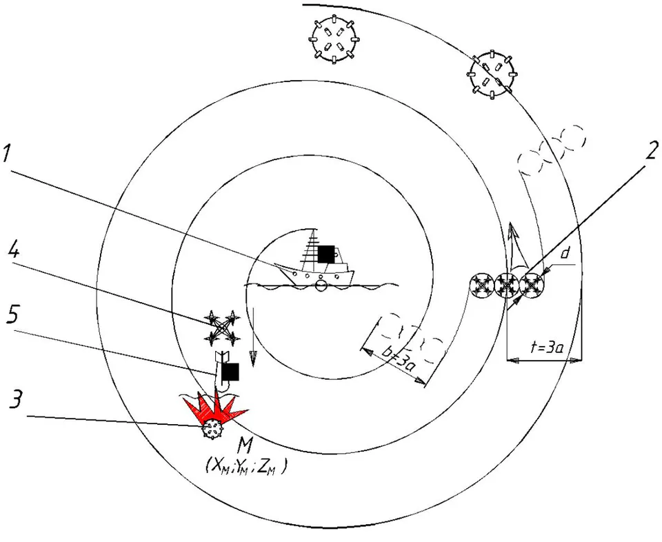
Fig. 1: The trajectory of spatial movements of search drones along the Archimedean spiral
Search drones 2 arranged in one line are given a command to spatially move this trio of drones along an Archimedean spiral, whose pitch is equal to
where b=3a – the width of the area of simultaneous coverage of the search zone by the drones 2; d and r – diameter and radius of the hemisphere of the action of the search radar equipment respectively.
The center of the Archimedean spiral, along which the search drones move in the air, is conventionally arranged on the trawler boat 1, and the flight height does not exceed the radius r of the effective action of the search equipment. With the above parameters of search equipment, the following parameters of the flight path of search drones could be recommended as optimal:
- Flying height – 50 m;
– pitch of the Archimedean spiral of spatial movement of the drones;
r=50 m – radius of the hemisphere of the effective search of radar equipment;
b=3a=3·100=300 m – the width of the search area covered by three drones.
The trajectory of the search drones 2 along the Archimedean spiral was chosen for two reasons:
This trajectory does not allow the presence of unsurveyed areas of the sea water area;
This smooth trajectory, unlike other possible ones, does not involve reverse movements and sharp turns, which is not desirable for aircraft.
If we take the speed of search drones as the average permissible flight speed v=5-5,5 m/s=18-20 km/h, then in one hour these three search drones will survey approximately six square kilometers of sea water area during their spatial movements along the Archimedean spiral.
In the event that any of the search drones 2 detect a floating mine, their Archimedean spiral flight over the territory is suspended. According to the appropriate command from the command post of the trawler boat 1, the drones 2 "hover" over the detected mine, locating above it in an equilateral triangle, the geometric center of which coincides with the point of placement of the mine 3 [6, 14].
After that, the observational identification equipment is turned on simultaneously on three drones to identify the object detected by the drones 2 on the sea surface. It is the observation and photos of a floating object from three points (drones) shifted 1200 from each other that make it possible to build a solid-state model of the object under study on computer screen. That is why exactly three search drones are used simultaneously in this mine search scheme.
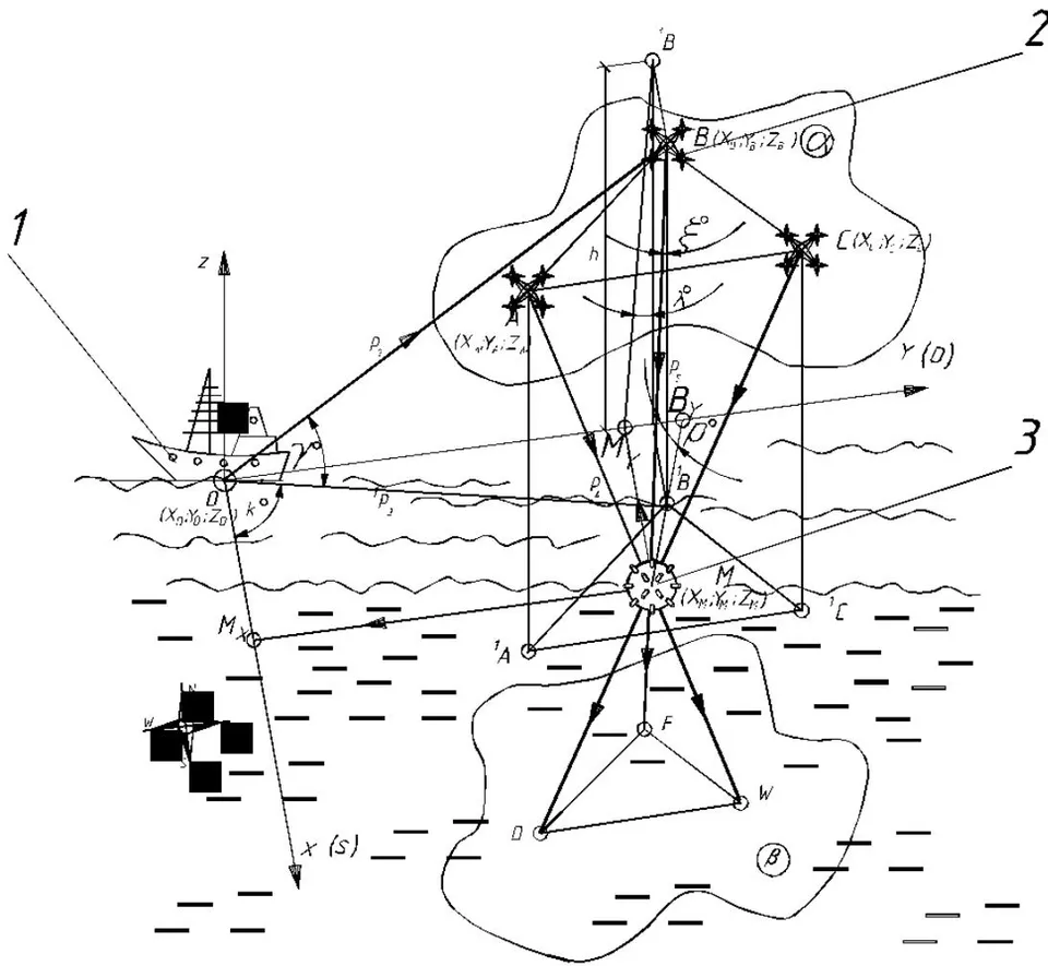
If a floating object discovered on the surface of the sea turns out to be a floating mine, they proceed to its disposal. To do this, they first of all determine the coordinates of location of this mine using an appropriate computer program. This program involves the introduction of an imaginary system of orthogonal spatial Cartesian coordinates with the location of the origin of the coordinates at the location of the trawler boat 1 (Fig. 2). The x-axis is tentatively directed towards one of the geodetic sides of the world of the investigated mine search area, for example, to the south. The y-axis perpendicular to it is in the direction of the other side of the world, for example, to the east. The z-axis is directed upwards perpendicular to the other two axes. The horizontal plane of projections of this coordinate system formed by two mutually perpendicular x and y axes coincides with the surface of the sea.
The directions of the axes are assigned in such a way that the detected mine and search drones are located within the first octant of the space outlined by the projection planes (Fig. 2) [10].
![Fig. 2: Scheme for calculating the coordinates of a floating mine detected by search drones [10]](https://doc.journalspress.com/pacl50_107731/ocr/images/derivatives/b8/b826b2c242c39fcdd9ac60312c75bbda6601ce687bb339a15d6c68d9c2316012.webp)
The radar station installed on the trawler 1 determines the coordinates of each drone placed over the mine 3 in the introduced system. These coordinates include the distance 1 from the radar to each of the three search drones 2 that are currently placed over the detected mine 3, as well as the angles of inclination of the imaginary projecting rays passing from the radar to each of the drones. In Fig. 2, these structures are marked as follows:
Search drones N°1-A, N°2-B, and N°3-C, and their projections on the sea surface plane A, B, C respectively;
Distance from the radar station to the search drones ; ; ;
Projecting rays that pass from the radar station through the search drones– . Their projections on the sea surface plane are respectively;
Angles between projecting rays and their projections on the sea surface area respectively:
Further calculations of the coordinates of the location of the detected mine are carried out using the appropriate software according to the following algorithm .
First, from the respective triangles \Delta AO^{1}A, \Delta BO^{1}B, and \Delta CO^{1}C, the height of the drones 2 above the sea surface h = l_{1}\sin\varphi is determined and equalized for all the three drones. The plane formed by the three drones 2 is denoted as the base plane \alpha (A, B, C). This base plane \alpha is parallel to the sea
The calculation program further provides that imaginary projecting rays pass from the portable radar stations of the drones through the drones 2 themselves and the detected mine, that is , and . The angles of inclination of these projecting rays to the corresponding perpendiculars from points A, B and C to the surface of the sea plane are recorded:
Below the sea surface, at the depth of , an imaginary so-called "picture" plane is arranged by the calculation program parallel to the sea surface and the base plane . The imaginary projecting rays , and p6 that pass from the search drones through the detected mine M are continued to the intersection with the "picture" plane and the coordinates of their intersection points are calculated, namely
At the same time, for spatial binding of projecting rays to the selected coordinate system, the angle of their inclination to any vertical projections plane of the selected coordinate system is additionally determined from the azimuths of the projecting rays determined by drone radars. For example, the profile plane , formed by the intersection of the y and z axes. Then
The two pyramids MABC and MWFD formed by projecting rays , and and mutually parallel bases are similar. Their base planes (A, B, C) and (W, F, D) are mutually parallel. These pyramids have a common vertex at point M, where the detected mine is located. The angles of their corresponding faces at the vertex M are equal to each other, and the side edges of one pyramid are extensions of the edges of the other. Having the coordinates of points A, B and C at the base of the upper pyramid ABCM as measurement data of the trawler boat 1 radar station and the coordinates of points W, F and D at the base of the lower pyramid as measurement data of drone radars, it is possible to calculate the coordinates of the common top of these pyramids, i.e. point M as the point where the detected floating mine 3 is currently located.
The projecting ray that is tentatively directed from the the trawler boat 1 radar station towards drone 1 (point A in Fig. 2) and its projection onto the horizontal projections plane , as well as the connecting line between the points A and form the plane established by the triangle that is perpendicular to , i.e. . The radar station azimuth by the projecting ray allow establishing its inclination angle to , i.e. and clarifying the location height of drone 1 (point A) above the sea surface
where l=OA - the distance from the trawler boat to drone 1 determined by the radar station.
The length of the projections of the projecting ray on the horizontal projections plane is
Then the coordinates of the points A and are determined from the right triangles and
Here - the angle between and the x axis.
Therefore, all the location coordinates of drone 1 (point A), drone 2 (point B), and drone 3 (point C) are determined in the selected coordinate system, namely:
Here - the angle between the projection of the projecting beam and axis x Fig. 3, and the angle - is the angle between the projection of the projecting beam and axis x Fig.
Using the portable radar, the projecting ray is visually directed from drone 1 located at point A to the detected mine lying on the surface of the sea at point M. In our case, in the selected coordinate system, point M, i.e. the detected mine, is placed on the horizontal projections plane . Similarly to the previous case, the projecting ray was considered (Fig. 2). Its projection on , i.e. and the connecting line form a right triangle , whose plane is perpendicular to the projections plane . The plane of this triangle is inclined to the projections plane at an angle of . Using the azimuth of the drone 1 radar, the inclination angle of its imaginary projecting ray to the connecting line is determined, namely .
The length of the segment AM is determined from the right triangle
and the difference between the coordinates of the points A and M is determined from the right triangle AMK, i.e.:
Therefore, the coordinates of the located mine 3 (point M) in the selected coordinate system will have the following calculated values:
The "+" sign is used in the above dependencies if the angle is acute, and the "-" sign is used if the angle is obtuse. Thus, using a simple calculation program, on the basis of the data provided by the radar system installed on the trawler boat 1 and the data from portable radars on drones, the coordinates of the floating mine 3 detected by the drones 2 are determined.
To clarify the coordinates of the mine, the above calculations are duplicated for the other two drones. The initial data for these calculations and the calculation scheme are shown in Fig. 3 and Fig. 4.
Source: Own development
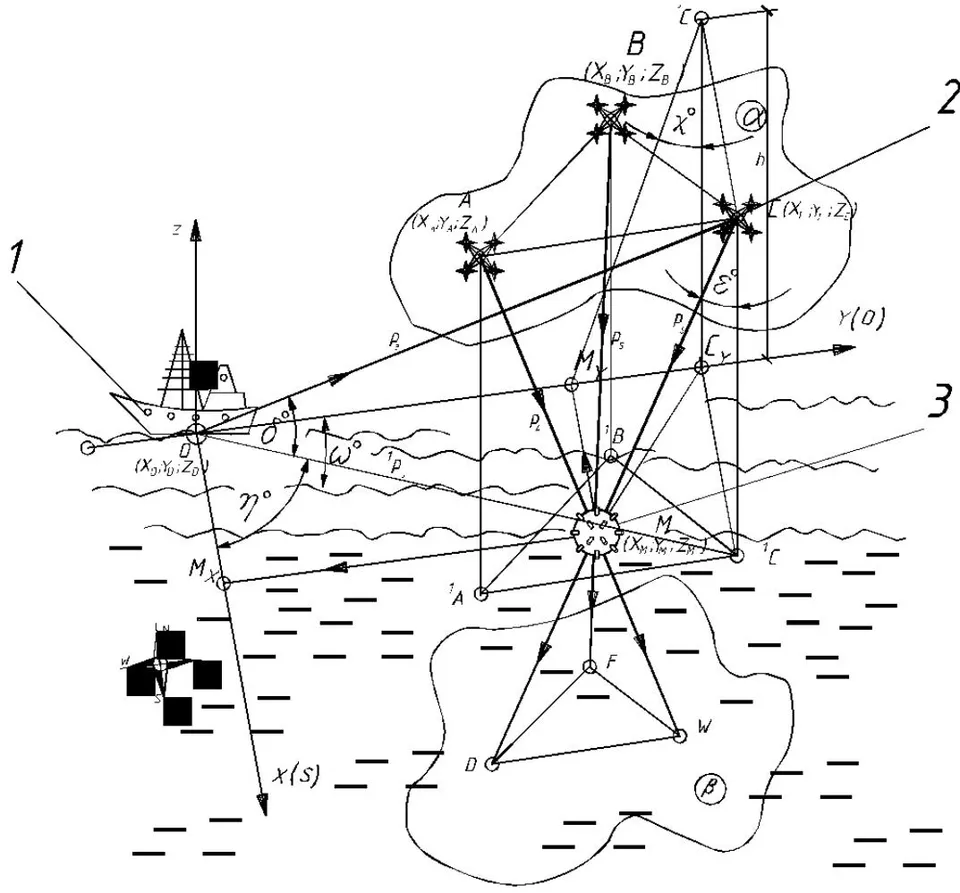
Fig. 4: The scheme of specifying the coordinates of the found mine by drone N° 3 (point C) In order to check the correctness of the calculations, the coordinates of the points W, F, and D are determined according to a similar scheme on the projecting rays , , that are located on the parallel base "picture" plane . Having the coordinates of the points at the ends of the segment of the projecting ray, one can write down the following equation of the straight line passing through the two points with known coordinates ; ; ; ; .
Then the equation of the straight lie will be as follows
Similarly, for the projecting ray passing through drone 2 (point B), the detected mine 3 (point M), and point F with known coordinates , the equation of the straight line passing through the projecting ray will be as follows
All the same constructions and calculations are made for the third ray passing through drone 3, mine M and point D on the "picture" plane. The equation of the straight line passing through these points will be the following:
Equation systems are formed from any two equations of projecting rays, and by their joint solution, the coordinates of points M, in which the detected mine 3 is located, are searched. If the detected coordinates of the point of intersection of the three projecting rays match in all the above-mentioned check steps, it may be concluded that the calculated coordinates of the mine correspond to their real value.
To neutralize the detected mine 3, the crew of the trawler boat 1 decides which available method of direct mine neutralization to use. Several options are possible, including mine detonation using a UAV. In this case, drone 4 available on the trawler boat is used. In the automatic holder of this drone 4, a corresponding warhead 5 is installed, the explosive substance of which is sufficient to detonate the detected mine. The liquidator drone carrying a warhead is given calculated coordinates of the detected mine 3 and is directed to liquidate the mine (Fig. 5).
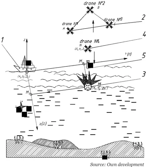
Search drones N°1, N°2, and N°3 rise to a safe height, the drone 4 that detonates a mine is located above the mine 3 and, if possible, once again checks the type of the mine with a video camera and waits for the command to take further actions. The command post finally analyzes the safety of mine 3 explosion for the environment, for people, and the search equipment and gives the command to detonate the mine. The launch mechanism of the liquidator drone 4 that detonates a mine unlocks the warhead 5 holder and the explosive charge falls directly on the mine 3 or next to it in the water. As a result of the explosive contact of the warhead with the mine or water, the warhead explodes, provoking the explosion of the detected mine 3 due to its mechanical damage or detonation of the explosive substance.
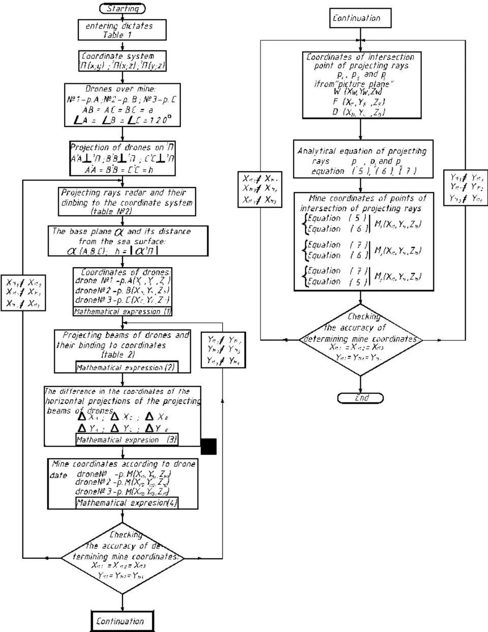
Figure 6 shows a block diagram for making calculations and building a computer program to determine the coordinates of a floating mine detected by UAV. The calculation block diagram requires inputting some data, such as the model and number of search drones, characteristics of their spatial location and movement, flight height during the search for floating mines.
Tabular input data of the block diagram for calculating the coordinates of floating mines
Table 1
| Item | Name of the given parameter | Designation and numerical value of the given parameter |
| 1 | Number of search UAV | UAV model - Number of UAV – 3 |
| 2 | Trajectory of UAV search movements | Archimedean spiral Interturn distance or spiral pitch t = 3a=3·100=300 m, a =100 m – distance between drones |
| 3 | Search area band width | b=3a=3·100=300 m |
| 4 | UAV location at the time of mine detection | Triangle ABC with the length of each side a=100 m and angle 120° at vertexes |
| 5 | UAV location height above the detected mine | h=25–50 m |
The calculation itself is completed in a few stages, namely calculating the distance between the base trawling boat to each drone placed above the mine, calculating the coordinates of projections of the search drones onto the sea surface, determining the length of the projecting rays generated by the drones onto the detected mine etc. Based on these data, mine coordinates are calculated, and their accuracy is checked. In case of discrepancies in the data calculated for each of the search drones, the angles of inclination and the length of the projecting rays of the trawler boat radar station and the similar data of the search drones are clarified (Fig. 5).
Parameters of projecting rays and their projections in the selected coordinate system (Fig. 2, Fig. 3, Fig. 4)
Table 2
| Item | Projecting rays of the trawling boat radar station (Fig. 2) | |||
| Elements of the spatial arrangement of projecting rays and their projections | Drone 1 | Drone 2 | Drone 3 | |
| 1 | Length of projecting rays | |||
| 2 | Length of projections of projecting rays | |||
| 3 | Angles of inclination of projecting rays and their projections to the sea surface (horizontal projections plane );Angles of inclination of projections of the projecting rays to the x axis | |||
| Projecting rays and their projections generated by search drones (Fig. 3, Fig. 4) | ||||
| Elements of spatial arrangement of projecting rays and their projections | Drone 1 | Drone 2 | Drone 3 | |
| 4 | Length of projecting rays of the drones | |||
| 5 | Length of projections of projecting rays of the drones | |||
| 6 | Angles of inclination of projecting rays and their projections to the vertical connecting line | |||
| 7 | Angles of inclination of the planes passing through projecting rays perpendicular to the sea surface to the projections plane | |||
| 8 | Angles of inclination of projecting rays to the profile projections plane | |||
Source: Own development
Fig. 6: Block diagram for calculating the coordinates of detected floating mines.
Thus, when using this method of searching for and neutralizing mines, there is practically no need for people in the command post of the trawler boat to come into direct contact with a life-threatening mine. However, demining situations can be different, of course. For example, the power of the warhead dropped from a liquidator drone may not be enough to detonate a mine. Then the trawler boat will have to trawl the area of the sea where the mine is located or use other more powerful means of neutralizing mines such as, for example, floating drones equipped with guided destroyer torpedoes or the so-called kamikaze robots. Their self-detonation on a detected mine destroys its shell and the mine either explodes or collapses, ceasing to be a threat to people and vessels.
IV. DISCUSSION
Like most engineering solutions, the proposed method of demining seas and rivers has both advantages and disadvantages. Arguably the most significant drawback is that it is only suitable for floating mines drifting on water surface. It is not suitable for demining the so-called anchor mines nor for neutralizing bottom mines because portable radars equipped with search drones cannot effectively scan the water layer in which these mines are located.
Another noticeable disadvantage of the proposed demining method is its critical dependence on weather conditions. Winds with a speed of more than 7-8 m/s, waves 1.5 meters high, excessive smog in the air, intense rain or snowfall – all these conditions make using drones impossible, and, accordingly, make it impossible to use kinematic projection for locating mines on the sea surface.
A certain disadvantage is that mines detected by this method cannot be deprived of buoyancy or fixed at the place of their detection. Therefore, these detected floating mines must be neutralized immediately upon detection. Otherwise, they may be carried away by winds or currents to other areas and search for them will have to be started again.
On the other hand, there are two undeniable advantages to the method of using kinematic projection for detecting floating mines. First of all, it is complete elimination of people both from searching and demining. This is very important, because the demining process is not only long-term, but also extremely dangerous for the trawler crew and divers.
Another significant advantage of this demining method is relatively high productivity and speed of search operations . Wide area coverage by three drones and their coordinated movements along the Archimedean spiral contributes to effective search operations. The method eliminates the presence of unsurveyed areas, which are rather common during round-trip movements of search vessels.
Another important positive aspect is minimized search movements of the trawler. It either stands at anchor or drifts with minimal consumption of fuel by the propulsion engines. Undeniably, this compensates for the costs of purchasing search equipment for drones and creating software for managing search movements of the drones. After all, in order to patrol a sea area of , a boat would have to sail about 20 kilometers an hour, spending about 20 liters of fuel worth about 1,000 hryvnias, and there will be at least 5-6 such plots during one working day, therefore it is a daily saving of 5-6 thousand hryvnias.
Unfortunately, given the military events on the territory of Ukraine, the authors of the article were unable to carry out field tests of the proposed demining scheme. The authors hope to do this in the future in peacetime and invite all individuals and organizations interested in the results of this research to cooperate.
V. CONCLUSIONS
The rapid development of science and technology at the turn of the millennium significantly improved military weapons in general and means of mining both on land and in water in particular. The latest technologies of manufacturing explosives, modern materials used for the manufacture of mines, high-quality electronics for controlling the moment of explosion, and other achievements have turned modern mines from a "passive bystander" into powerful hyperactive autonomous destroyers of water vehicles.
Among various types of mine weapons used in the water areas of rivers and seas, floating mines are the least powerful. However, they are the most insidious due to the lack of controllability of their movements by winds, currents, and waves. Therefore, along with the danger to military vessels, these mines are even more dangerous to the civilian population living, working or resting on the shore. Having drifted to the shore or hitting coastal rocks, this mine suddenly explodes even from a shock contact with the soil or stones.
The essence of the proposed method is to use a group of UAV of the drone type to search for floating mines, the results being reduced to the calculation of the coordinates of the detected floating mine by means of kinematic projection. The use of small, economical search aircraft eliminates the need for search movements of trawler boats. This significantly reduces the cost of search operations and increases their safety for the trawler crew.
From among all the possible trajectories of movement of UAV and trawlers when searching for floating mines, three drones arranged in a row along an Archimedean spiral with an interturn step proportional to the number of search drones and the radius of effective action of their search equipment is recommended as the optimal flight trajectory.
Despite certain disadvantages of the method of searching for floating mines using kinematic projection, such as increased sensitivity to weather conditions, especially wind, this method has the prospect of wide practical application, mainly due to elimination of people's contact with the mine and elimination of movements of the trawler boat, thereby significant fuel saving, as well as high accuracy.
Conflict of Interest
The authors declare no conflict of interest.
Ethical Approval
Not applicable
Data Availability
The datasets used in this study are openly available at [repository link] and the source code is available on GitHub at [GitHub link].
Funding
This work did not receive any external funding.
References
Cite this article
Related Research


Special Issue
Launch a focused special issue to highlight research, emerging trends, and expert insights in your academic field.