




IntelliPaper
Abstract
Since the first trip to Mars, rovers have been used to conduct scientific experiments. The use of rovers continues to date due to Mars being uninhabitable for humans at this state and time. Despite the invention of Mars rovers, many limitations have been challenging space exploration, even with improvements in the Curiosity and Perseverance rovers. This study aimed to investigate the advancement in autonomous navigation in space through artificial intelligence. The study used qualitative, desktop, and systematic review research designs. The study's objectives were to determine the types of autonomous navigation technologies in space and examine the role of artificial intelligence in autonomous navigation technologies. Data was collected from secondary sources, which were purely open-access online journals. A total of 61 journals were searched as the target population. The study then conducted judgmental sampling using 9 out of 61 journals. The Preferred Reporting Items for Systematic Reviews and meta-analysis guidelines guided the sampling process. The study used an extraction form to collect data. The study found that star tracker navigation reduces positioning errors and environmental disturbances from sand and dust storms. It was also established that LOS navigation and star trackers ensured highly accurate navigation in challenging conditions for path-planning accuracy. Selecting the Next Coordinate, Obtaining Coordinates of Target Points, Generating Additional Coordinates, and optimising planned paths reduce travel time and energy consumption. On-orbit servicing robotics can extend rover missions up to 10 years. It was also found that 3D OctoMaps improves rovers' navigation accuracy. In addition, the study revealed that unsupervised homography networks, state recursive models, and inertial measurement models reduce localisation errors. Simultaneous Localization and Mapping can improve navigation accuracy and reduce mission delays. The use of RL navigation systems reduces mission delays. It was also found that Convolutional Neural network algorithms advance autonomous navigation accuracy in terms of terrain classification. The study also established that the Nvidia Jetson Nano AI controller and Rapidly-exploring Random Tree (RRT) in MATLAB reduce travel time and energy consumption. Finally, it was found that artificial neural networks advance the accuracy of terrain classification and lower navigation errors.
Explore Digital Article Text
I. INTRODUCTION
1.1 Background
Artificial Intelligence (AI) advancements form the basis for advancing AI-driven autonomous space exploration technologies. Examples of successful inventions currently dominating different sectors include self-driving vehicles (i.e., the Tesla Model Y), manufacturing robots (i.e., the Cartesian robots), warehouse operating robots (i.e., Proteus in Amazon), building and construction robots (i.e., Vulcan and Phoenix by ICON), humanoids (i.e., Optimus by Tesla, and Atlas from Boston
Dynamics) (Hansson et al., 2021; Tennant et al., 2024; Garikapati & Shetiya, 2024). Given that these technologies are already successful in their application, putting them into space exploration can boost the science of space exploration. The scope of application of advanced autonomous navigation in space through artificial intelligence is broad.
Space exploration has been in existence since 1957 (Siddiqi, 2010). After the launch of Sputnik, several other innovations have been made in the history of space exploration. The year 1998 marked the start of advancement in autonomous navigation in space with the help of artificial intelligence. This was related to the launch of the Deep Space 1 probe. Each year, scientists have been developing more advanced technologies to explore space. Humanity has been fascinated with planetary explorations besides flights into space and space satellites. The introduction of autonomous rovers led to a big leap courtesy of Artificial Intelligence, as seen with the launch of NASA's Sojourner rover that operated on Mars as a pathfinder in 1997. The rover utilised basic AI algorithms to navigate and avoid obstacles on the planet's surface. After the successful operations of the Sojourner rover, scientists have advanced other rovers that have increasingly achieved their intended roles. Examples of autonomous rovers sent to Mars after the Sojourner include the Opportunity (2004), the Curiosity (2012), and Perseverance (2020) (Zhou et al., 2024). Despite the advancement of autonomous innovations driven by AI being used on Earth, space exploration has limited application. Comparing the list of AI-driven autonomous innovations on Earth and in space (such as on the moon and Mars), space exploration is still ranked as the least advanced sector in such applications. There are various reasons why the space exploration sector is still lagging in applying advanced AI-driven autonomous innovations. One of the significant reasons is monopoly. Governments have dominated space exploration for years, leaving out the private sector. This slowed the competition to innovate advanced AI-driven machines (Pagallo et al., 2023).
AI is being adopted to solve long-duration missions and increase reliance on plans to operate autonomously in space. AI algorithms characterise spacecraft's autonomous navigation. According to the study, this increases efficiency in navigating complex space environments, which demand keenness, increased attention to avoid obstacles, and optimisation of trajectories. The use of machine learning and sensor data was the key highlight of the study in realising real-time informed decision-making in autonomous navigation, thereby achieving efficiency and reducing ground control dependency (Russo & Lax, 2022).
For example, since the launch of the SpaceX company in 2002, aggressive space exploration technological advancements have been made in such a short period. The company is set to make a better and appropriately modified rover to succeed the Perseverance rover launched to Mars in 2021 by NASA. These speculations are the subject of debate regarding the advancement required to establish a long-lasting impact on AI-driven autonomous space exploration technology. To date, NASA has continuously made rovers with the same characteristics, including appearance and functionality, with the significant differences being size and software updates (Rausser et al., 2023).
This study sought to establish advancements in autonomous navigation in space through artificial intelligence by systematically reviewing past journals. The researcher will conduct a comparative analysis of issues surrounding this advancement. The findings formed knowledge that sought to inform the scientific community of the possible opportunities in AI-driven autonomous machines that, if implemented, can transform space exploration in the future.
1.2 Objectives
1.2.1 General Objective
To analyse advancements in autonomous navigation in space through artificial intelligence.
1.2.2 Specific Objectives
1. To determine types of autonomous navigation technologies in space;
- To examine the role of artificial intelligence in autonomous navigation technologies in space.
II. LITERATURE REVIEW
The study by Xiong et al. (2024) established that autonomous optical navigation in estimating a spacecraft's velocity while in Earth orbit is a required advancement. The study proposed the "novel autonomous optical navigation method" to improve navigation. This method involves a star camera placed on a spacecraft that collects measurements in a line-of-sight (LOS), with the focus being the number of non-cooperative space targets whose vectors are not precisely known ahead of time of contact. The proposed novel autonomous optical navigation method is meant to improve the "Q-Learning Extended Kalman Filter", thereby obtaining accurate motions for both the space targets and spacecraft using the measurements by the LOS direction. LOS can accurately acquire the direction of space targets if an additional advanced star camera is used. During the movement of a spacecraft, its position, attitude, and velocity are obtained using the star camera while the space targets and stars are simultaneously observed.
Zhang et al. (2024) studied using autonomous rubber-tapping robots installed with trajectory prediction decision mechanisms to navigate forests. The use of the navigation decision mechanism deals with obtaining coordinates of target points (OCTP), selecting the next coordinate (SNC), generating additional coordinates (GAC), and finally optimising planned paths (OPP). Using mechanisms, robots increase their autonomy in predicting their next target based on their current position and actual operating logic during their navigation within forested environments, with an overall rationality effectiveness of 92.14% for path planning.
Li et al. (2025) studied the 3D point cloud optimisation method using an octree data structure as a solution to autonomous navigation and a replacement to the 3D LiDAR's contribution towards autonomous navigation of the robots called orchard mobile. According to the study, the 3D point cloud optimisation method advances mapping and spatial indexing and introduces the octree data segmentation features and structure. According to the survey, sparsity and density in the point cloud mapped by the 3D orchard get adaptively divided, and key information about the orchard is retained. Regarding path planning, the octree nodes random tree expansion and improved algorithm proposed by the octree. The results of the tests revealed a score of -76.32% reduction of point cloud data points within a map. The robot improved the RRT algorithm significantly when dealing with path generation time, curvature, sampling point utilisation, and path length. Lateral tracking errors improved with a decrease in the resolution of octree nodes. For example, 0.20 m resolution achieved 0.079 m lateral tracking error, indicating strong path tracking.
Gao et al. (2024) studied the implementation of an unsupervised homography network. The purpose of the technology was the interframe motion lander estimation (position, attitude, and velocity) using an inertial measurement information/measurement model and a state recursive model. The results of the simulation showed that the tool was effective. Zhao et al. (2024) studied using SLAM-driven autonomous navigation instead of traditional algorithms. According to the algorithm, SLAM enhanced precision in autonomous navigating robots with less than a 5% error rate.
Duarte et al. (2024) studied cameras and active sensors with their advancements in AI navigation algorithm to increase on-board visible wavelength as a docking sensor and on-orbit servicing (OOS). According to the study, these sensors reduce dependency on lidars. To improve navigation, several Convolutional Neural Networks (CNN) form a benchmark for generating synthetic data that drive docking manoeuvres applied in the International Space Station (ISS). Haj et al. (2024) studied the incorporation of Nvidia Jetson Nano AI control systems. Using advanced mechanical, software, and electrical components, rovers can withstand harsh conditions in places like Mars, powered by MATLAB's RRT AI planner, to optimise navigation systems and path planning.
Ying et al. (2024) studied the inadequacy of the Kalman filter using multi-sensor autonomous navigation with intelligent information fusion to operate launch vehicles. To improve navigation, the study proposed using Artificial Neural Networks (ANNs) to connect data with trajectory parameters. The tracking, control system and telemetry provide accurate launch vehicles after every flight. The experiment results showed that ANNs improve navigation performance compared to the Kalman filter.
III. MATERIALS AND METHODS
The Preferred Reporting Items for Systematic Reviews and Meta-Analyses (PRISMA) guidelines guided this study section (Flow Chart 1) below.
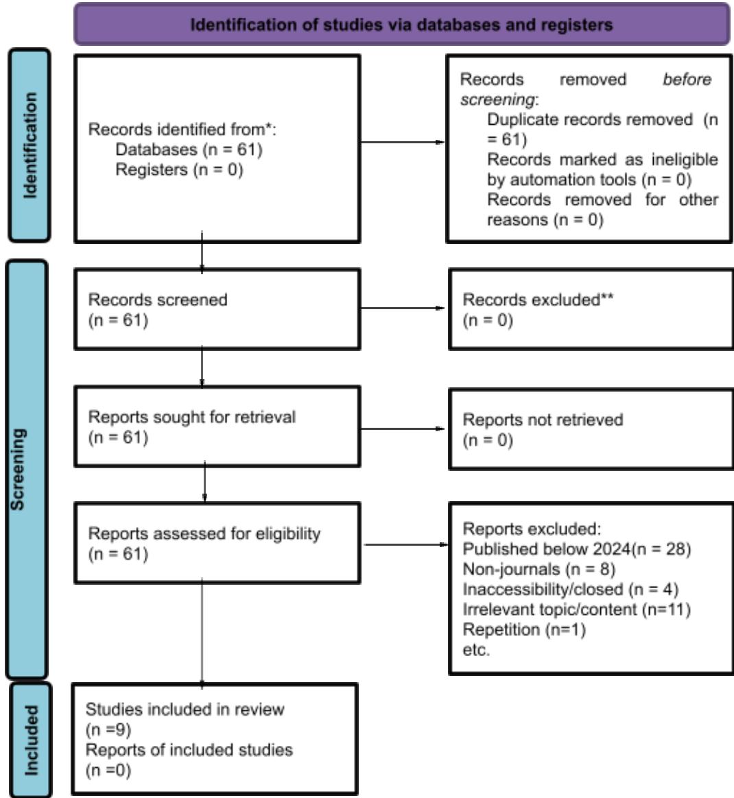 Figure 1: PRISMA 2020 flow diagram for new systematic reviews, which included searches of databases and registers only Source: McKenzie et al. (2021)
3.1 Eligibility Criteria
The inclusion criteria were as follows: Sources should be published in journals. The publishing should have happened between 2024 and 2025.
The sources should be open-access, making them available to the public on the most used search platform worldwide. Finally, the sources should be relevant to the topic and objectives of this study. The exclusion criteria are Older Sources, i.e., 2023 backwards. Sources that are anything other than open-source published journals, meaning no reports, unpublished theses, numerical data from statistics websites, and websites in general. After assessing various sources totaling 61, this study excluded 52, remaining with 9 (nine) sources used for the systematic review.
3.2 Information Sources
The study used the extraction form provided in Table 1 to identify suitable sources that led to the findings reported in this study. The extraction was therefore considered as the data collection tool for this study.
Table 1: Extraction Form
| Study ID | Inclusion criteria | Exclusion criteria | Selected /Not Selected | Was the author contacted for additional outcome data | Contact record | Date last searched/ consulted. |
| [] Published 2024-2025 [] Journal (type) [] Open source [] Relevant | [] Published 2023 backwards [] Non-journal (type) [] Inaccessible [] Irrelevant | [] Yes, positive response [] Yes, but no response [] No [] It was N/A |
3.3 Search Strategy
The researcher used qualitative, desktop, and systematic review research designs to identify scholarly articles from journal publishing websites. The search included: "Types of Autonomous Navigation Technologies in Space – journal" and "Role of Artificial Intelligence in Autonomous Navigation Technologies in Space – journal." The study directly searches the internet using Google browser and Google Scholar). The source filtering was limited to the extraction form (Table 1).
3.4 Selection Process
The data sources and findings were selected based on what the study extracted from the data collection form (Table 1). All 9 (nine) sources met the inclusion criteria for the review. The researcher and four research assistants (reviewers) reviewed the sources by screening for quality and context suitable for this study. The supervisor, a professor in Artificial Intelligence and mechatronics at Cambridge University validated and confirmed the suitability of the studies selected for systematic review. Independent reviewers conducted the review process through anonymous peer review (meaning the absence of influence from the authors and the absence of knowledge about the author). During the entire process, the review discouraged using automation tools.
3.5 Data Collection Process
An extraction form was used to collect data. The sources of data were 9 (nine) journals. First, the researcher identified the topic of the study. The researcher then identified the objectives of the study. The researcher used the following search phrases to obtain the required data sources: "Types of Autonomous Navigation Technologies in Space – journal" and "Role of Artificial Intelligence in Autonomous Navigation Technologies in Space – journal." The researcher searched the internet using Google and Google Scholar search bars. The search resulted in a total of 61 journals. The researcher then used the extraction form in Table 1 to further evaluate the data sources. The researcher was guided by the PRISMA 2020 flow diagram proposed by McKenzie et al. (2021) to highlight the exclusion criteria for selecting the sources. After exclusion, the researcher was left with a total of 9 (nine) sources. The researcher then hired 4 (Four) reviewers to validate the selected sources to be reviewed and analysed for the study. Upon confirmation that the data collection sources were suitable, the researcher collected and analysed the findings.
3.6 Study Risk of Bias Assessment
The study was limited to findings from 9 (nine) sources out of 61. This produced a potential bias caused by the exclusion criteria used. It was necessary to use the exclusion criteria to minimise the use of old sources considered outdated information. This does not mean that older sources lacked important information, risking the study's findings from being adequate and inclusive.
To assess the risk of bias, the researcher applied the Robvis method. Robvis visualises the risk of bias. It is an open-source web app that evaluates the risk of biased figures and provides a synthesis workflow in R-studio. The researcher backed up the process by conducting a peer review manually. The study employed 4 (four) reviewers who certified and selected the 9 (nine) sources independently.
3.7 Effect Measures
The effect measures were determined using the Odds Ratio (OR) synthesis. The odds Ratio (OR) estimates the odds of "Event A" divided by the odds of "Event B". The results were interpreted as follows: OR values near 1 meant the approximate effects were almost identical for groups A and B. In reverse, OR values far from 1 meant a lower identicality of the two events (A and B). This study achieved an OR equal to 0.7, considered adequate regarding the identicalness of the 9 (nine) sources. This meant the 9 (nine) sources adequately complemented each other with a high level of reliability, thus giving this study the go-ahead to conduct the systematic review.
3.8 Synthesis Methods
Table 1 was used to determine the number of sources being used for the study. A total of 9 (nine) sources were reviewed and found eligible. Data collection used secondary sources such as scholarly articles and analysed using qualitative analysis. Qualitative analysis was a thematic data coding that sought common trends and themes from the chosen sources.
3.9 Reporting Bias Assessment
The risk of bias assessment involved using the Robvis methods during the inclusion and exclusion criteria.
3.10 Certainty Assessment
To determine confidence levels related to the sources set aside for data collection, the research used Cronbach's alpha to test the reliability of the extraction form. It established an alpha value above 0.7, which was considered sufficient. This allowed the researcher to proceed to the next step, data analysis.
3.11 Study Selection
The study collected data from two recommended studies by the supervisor at Cambridge University and reviewers of the list provided by the researcher, as presented in Table 1. Out of 61 studies, only 9 (nine) qualified to inform the systematic review. The other 52 studies were disqualified based on the exclusion criteria.
3.12 Study Characteristics
This systematic review is characterised by published journals between 2024 and 2025, considered open sources, with relevant information regarding the topic and objectives of this study.
3.13 Risk of Bias in Studies
Risks of bias were assessed using Cochrane's review criteria. The criteria work in stages: selecting, detecting, and reporting bias. Selecting bias deals with questioning/disapproving data sourcing, amounting to more than 50% of reviewers considering it inadequate. Detection bias deals with questioning/disapproving data sources by over 50% of reviewers and the other 50% of reviewers approving; therefore, it reports adequacy of 50%. Finally, reporting bias deals with approved data sources by more than 50% of reviewers (defining the adequacy as close to 100%). Each paper was evaluated as "Low Risk" (+), "High Risk" (-), or "Unclear Risk", as provided in Table 2.
Table 3: Risk of bias in studies
| Code | References | Protocol results | Selection bias | Detection bias | Reporting bias | Risk of Bias |
| 1 | Xiong et al (2024) | 83.33% | + | ? | + | Low Risk |
| 2 | Zhang et al. (2024) | 83.33% | + | ? | + | Low Risk |
| 3 | Alizadeh and Zhu (2024) | 83.33% | + | ? | + | Low Risk |
| 4 | Li et al. (2025) | 83.33% | + | ? | + | Low Risk |
| 5 | Gao et al. (2024) | 83.33% | + | ? | + | Low Risk |
| 6 | Zhao et al. (2024) | 83.33% | + | ? | + | Low Risk |
| 7 | Duarte, et al. (2024) | 83.33% | + | ? | + | Low Risk |
| 8 | Haj, et al (2024) | 83.33% | + | ? | + | Low Risk |
| 9 | Ying, et al. (2024) | 83.33% | + | ? | + | Low Risk |
Table 2 revealed that most of the sources of information were picked with a low risk of bias, making them adequate for data analysis.
IV. RESULTS
Xiong et al. (2024) offer insight into improving the Curiosity and Perseverance rovers' real-time adaptability and limited autonomy. According to the study, using novel autonomous optical navigation technology, line-of-sight (LOS) techniques, and star cameras can improve the accuracy of measuring and implementing the velocity of space targets. If this is applied, the rovers can perform precise navigation in real-time independent of Earth-based control limited by communication delays. Implementing the three systems will improve Mars rovers' autonomous estimation of navigating complex terrains and adjusting trajectories. By combining AI- with optical navigation methods, rovers built in the future will achieve more precision during obstacle avoidance and target selection. The star tracker optical device uses star patterns to determine the rovers' space orientation. On the other hand, LOS use celestial objects and visual landmarks in relative positioning.
Zhang et al. (2024) explained the need to adopt Selecting the Next Coordinate (SNC), Obtaining Coordinates of Target Points (OCTP), Generating Additional Coordinates (GAC) technology, and optimising planned paths (OPP). By applying these approaches, the Mars rovers are expected to achieve the highest level of rationality and effectiveness when conducting path-planning missions. Adapting these advancements will also reduce dependency on Earth-based control. Using mission objectives and environmental data, the RL-based Selecting the Next Coordinate (SNC) can autonomously determine the following rover navigations in real time. The challenges facing the
Curiosity and Perseverance rovers include deep reliance on Earth-based control and pre-programmed paths that delay missions. To deal with this, RL is required to help the rovers adapt to the dynamic environments by selecting coordinates.
Alizadeh's and Zhu's (2024) study can be used to build the On-Orbit Servicing (OOS) robotics towards improving Mars rovers. According to Alizadeh and Zhu (2024), OOS depends on advanced machine learning and neural network performances, enabling Mars rovers to conduct precise and safe manipulation, controls, object estimation, and path planning. These capabilities include handling uncertainties, fuel-optimized trajectories, docking manoeuvres, and collision avoidance. Applying similar AI-driven systems to Mars rovers could significantly enhance their ability to autonomously navigate complex terrains, avoid hazards, and optimise scientific operations. The On-Orbit Servicing (OOS) can improve the capabilities of Curiosity and Perseverance robots' maintenance and refuelling. The challenges facing the rovers include hardware degradation and limited fixed energy supplies. Robotic maintenance and refuelling can replenish power sources (i.e., plutonium-238 connected to RTGs) and replace worn components to address this.
Li et al. (2025) this study shares how 3D point cloud optimisers that use octree data structures can offer valuable improvements to Mars exploration rovers. According to Li et al. (2025), 3D point cloud optimisation and octree data segmentation are tools for advancing mapping, path planning and spatial indexing conducted by autonomous robots like the Mars rover. With the help of this approach, traditional systems like 3D LiDAR can be replaced. The other systems that can be used include the Rapidly-exploring Random Tree (RRT) algorithms and the random tree expansion for path planning efficiency. Therefore, this advances the Mars rover's ability to navigate autonomously while mapping complex Martian terrains. Octree's 3D point cloud optimisers include the OctoMap and the Point Cloud Library (PCL). These techniques apply hierarchical octree data to process, store, and analyse 3D imagery data. The Octrees divide 3D spaces into small recursive cubes called voxels, reducing storage complexity. Challenges facing the Curiosity and Perseverance rovers are their reliance on 2D maps and, to some extent, weak 3D data characterised by navigation errors when mapping complex terrain. The Octree systems offer real-time 3D obstacle detection and mapping to address this.
Gao et al. (2024) studied unsupervised homography networks for inter-frame motion estimation of position, velocity, and attitude. The study also explained using the state recursive and inertial measurement models. Simulations of the tool have witnessed an advancement of motion estimation precision in the navigation of robots in dynamic environments, and this includes addressing the need to advance Mars rovers' ability to adjust trajectories and motion autonomously and in real time. The challenge that Curiosity and Perseverance face includes relying on pre-programmed paths. Using the models as a solution can address this situation. State recursive (i.e., Kalman filters) and inertial measurement models offer a robust pose estimation, while the homography networks advance visual odometry.
Zhao et al. (2024) studied Simultaneous Localization and Mapping (SLAM) in autonomous navigation and demonstrated how SLAM navigation advances precision in robots and lowers error rates as opposed to traditional algorithms. SLAM is highly accurate and applicable to localising and mapping complex environments. SLAM can advance Mars rovers' autonomous navigation and exploration capacities by creating real-time maps while simultaneously determining their position inside the maps. Through this, the rover can navigate unpredictable and hazardous Martian territory with limited communication, making Earth's human guidance impossible. The challenges facing the Curiosity and Perseverance rovers include delayed Earth control and pre-loaded maps that delay or limit adaptability. To address this, the SLAM enables autonomous navigation in real-time by offering 3D mapping at high resolution.
et al. (2024) studied advancements in cameras, sensors, and AI algorithms for navigation. They demonstrated how integrating advanced cameras and sensors using Convolutional Neural Networks (CNNs) AI algorithms advances navigation and docking accuracy. According to the study, Convolutional Neural Network (CNN) advancements make proper onboarding of visible wavelength, real-time recognition of objects, and spatial mapping. The challenge facing the Curiosity and Perseverance rovers has been the reliance on Earth-based control and pre-programmed instructions. These challenges have led to delayed decision-making caused by communication lag (i.e., 4–24 minutes). With the advancement in Neural Networks such as CNNs, it is established that decision-making will be in real-time and, thus, an increase in autonomous navigation. The other challenge facing the Curiosity and Perseverance rovers is the limited onboard power processing that restricts the analysis of complex terrain within actual time. Therefore, using sensor data and integrating CNNs can increase transformers' processing speed and high-resolution images. This will increase the accuracy of classifying terrain types and hazard detection with mote.
Haj et al. (2024) studied the Nvidia Jetson Nano AI controller integrated with the Rapidly-exploring Random Tree (RRT) in MATLAB. According to the study, Nvidia Jetson Nano with RRT in planner rover optimises autonomous navigation through path planning trajectory generation, thereby increasing obstacle avoidance. As previously found, the challenge facing Curiosity and Perseverance rovers is the need for backup regarding the existence of an Earth-base controller and a pre-programmed path, which led to suboptimal routes and delays. Applying the Jetson Nano and RRT technologies solves this problem by providing real-time processing of path planning.
Ying et al.'s (2024) study leads to the proposal of using multi-sensor navigation fused with intelligent information, in particular, applying Artificial Neural Networks (ANNs). According to the survey, using ANNs connects data and trajectory parameters, a combination that advances the tracking, controlling, and launch of robotic vehicles. The challenge facing Curiosity and Perseverance rovers includes pre-programmed instructions incapable of real-time performance. ANNs are a solution as they provide fast, real-time decision-making and learning.
V. DISCUSSION
The study aimed to systematically review advancements in autonomous navigation in space through artificial intelligence about the limitations challenging space exploration by the Curiosity and Perseverance rovers.
Xiong et al. (2024) proposed using novel autonomous optical navigation technology, line-of-sight (LOS) techniques, and star cameras. In support of the findings, Johnson et al. (2024) revealed that star tracker navigation reduces up to 50% of positioning errors compared to gyroscope systems and is immune to environmental disturbances, including sand and dust storms, which serve well on Mars. On the other hand, LOS navigation and star trackers ensure highly accurate navigation in challenging conditions. Smith et al. (2025) combined the two technologies and established that there will be improved path-planning accuracy of rovers of up to 40% in the Martian dust storms environment.
Zhang et al. (2024) proposed the use of the Selecting the Next Coordinate (SNC), the Obtaining Coordinates of Target Points (OCTP), the Generating Additional Coordinates (GAC), and optimising planned paths (OPP). Tomljenovic et al. (2024) support the finding by demonstrating how RL-SNC reduces travel time (i.e., by 30%) and lowers energy consumption (i.e., by 20%) when compared to past methods.
Alizadeh and Zhu (2024) proposed the adoption of the On-Orbit Servicing (OOS) robotics. According to Zhang et al. (2024), the OOS extends rover missions for up to 10 years, continuing their scientific exploration.
Li et al. (2025) suggested the application of 3D point cloud optimisers using octree data structures and rapidly exploring random Tree (RRT) algorithms and random tree expansion.
The study is supported by Serdel et al. (2024), who found that using OctoMaps improves rovers' navigation with up to 40% accuracy when simulations of Martian environments are conducted.
Gao et al. (2024) proposed the application of the unsupervised homography networks using the state recursive models and the inertial measurement models. In support of this, Annu et al. (2024) found that this technology reduces localisation errors by up to 50% during the simulation of rovers in Martian terrain.
The study by Zhao et al. (2024) proposed using the Simultaneous Localization and Mapping (SLAM). Alizadeh and Zhu (2024) found that SLAM improved rover navigation accuracy by 60% and reduced mission delays by 30% in simulated Martian terrains.
The study by Duarte et al. (2024) proposed the use of the Convolutional Neural Networks (CNNs) algorithms. In support, Thakker et al. (2023) revealed that RL navigation systems reduce mission delays by up to 40% as opposed to traditionally used system programs by NASA. Mathematically, CNNs advance autonomous navigation by accuracy regarding terrain classification (Solomon & Agnes, 2024).
The Haj et al. (2024) study suggested using the Nvidia Jetson Nano AI controller with the Rapidly-exploring Random Tree (RRT) in MATLAB. The finding was supported by Lee et al. (2024), who revealed that the presented combination of technologies reduces travel time by 35% and lowers energy consumption by up to 25%, as established by results from a simulation of rovers in a Martian environment.
Ying et al. (2024) proposed applying artificial neural networks (ANNs). In link to the finding, Sharma et al. (2024) established that ANNs advance the accuracy of terrain classification by up to 30% and lower navigation errors by up to 40% when a simulation of rovers in the Martian environments was conducted.
VI. CONCLUSION
The study aimed to systematically review advancements in autonomous navigation in space through artificial intelligence about the limitations challenging space exploration by the Curiosity and Perseverance rovers. The study studied advancements in cameras, sensors, and AI algorithms for navigation. The solutions presented include the use of modern neural networks, reinforcement learning (RL), genetic algorithms (GAs), and quantum computing algorithms. Xiong et al. (2024) proposed using novel autonomous optical navigation technology, line-of-sight (LOS) techniques, and star cameras. Zhang et al. (2024) proposed the use of the Selecting the Next Coordinate (SNC), the Obtaining Coordinates of Target Points (OCTP), the Generating Additional Coordinates (GAC), and optimising planned paths (OPP). Alizadeh and Zhu (2024) proposed the adoption of the On-Orbit Servicing (OOS) robotics. Li et al. (2025) suggested the application of 3D point cloud optimisers using octree data structures and rapidly exploring random Tree (RRT) algorithms and random tree expansion. Gao et al. (2024) proposed the application of the unsupervised homography networks using the state recursive models and the inertial measurement models. The study by Zhao et al. (2024) proposed using the Simultaneous Localization and Mapping (SLAM). The study by Duarte et al. (2024) proposed the use of the Convolutional Neural Networks (CNNs) algorithms. The Haj et al. (2024) study suggested using the Nvidia Jetson Nano AI controller with the Rapidly-exploring Random Tree (RRT) in MATLAB. Ying et al. (2024) proposed applying artificial neural networks (ANNs). All the applications were significant knowledge that this study recommended for advancing rover vehicles in the future of Mars exploration. The study hopes these technologies can be simulated comprehensively to benefit scientific planetary exploration.
List of Abbreviations
3D: Three-Dimensional
AI: Artificial intelligence
ANNs: Artificial Neural Networks
CNN: Convolutional Neural Network
CNN: Convolutional Neural Networks
GAC: Generating Additional Coordinates
GAC: Generating Additional Coordinates
LiDAR: Light Detection and Ranging
LOS: Line-of-Sight
MATLAB: Matrix Laboratory
NASA: National Aeronautics and Space Administration
OCTP: Obtaining Coordinates of Target Points
OOS: On-Orbit Servicing
OPP: Optimizing Planned Paths
PRISMA: Preferred Reporting Items for Systematic Reviews and Meta-Analyses
Q: Quality
RL: Reinforcement learning
RRT: Rapidly-exploring Random Tree
RTGs: Real-Time Gross Settlement
SLAM: Studied Simultaneous Localization and Mapping
SNC: Selecting the Next Coordinate
VII. DECLARATIONS
Ethics approval and consent to participate
A systematic review was used as the research design. Systematic reviews are findings obtained using secondary sources previously researched. In this case, the study investigated the advancement of autonomous navigation in space through artificial intelligence. The study was keen to ensure ethical approval, citing credible sources, authors and data.
Consent for Publication
The second author, a professor of AI-related studies at Cambridge University, supervised the first author. Therefore, the study sought the supervisor's consent to publish this research. The supervisor was then acknowledged as the co-author.
Availability of data and material
The study used a systematic review approach to collect and analyse secondary data. The method used published online open-access journals between 2024 and 2024, considered public information and accessible to public platforms.
Conflicts of Interest
The researcher was biased due to the topic, "Advancement in Autonomous Navigation in Space through Artificial Intelligence: A Systematic Review". The authors practice artificial intelligence-related careers. Because of this, the researchers ignored complementing and alternative fields attached to the topic. Therefore, some findings showed bias against other fields of knowledge unrelated to artificial intelligence. There were competing interests between the reviewers and the author, mainly because of their differences in experiences and careers. Because of these, changes to the main manuscript were intensive to streamline the published document to meet the conflicting thoughts, thereby making them uniform.
Funding
The author fully funded the study. The finances included family contributions.
Authors' contributions
Financing the project, A.I.; Supervising the project, A.I.; Study conceptualisation, P.L.; methodology, A.I.; validation, P.L.; formal analysis, A.I.; investigation, A.I.; resources, A.I.; data curation A.I.; writing—original draft preparation, A.I.; writing—review and editing, A.I.; and P.L.; project administration, A.I.; funding acquisition, A.I. All authors read, and agreed to move on with the published version of this manuscript.
ACKNOWLEDGEMENTS
I wish to extend my thanks to the reviewers assigned to ensure the validity of this paper. I also thank my parents for financing the writing of this paper and its subsequent publishing
Appendix 1 Graphic Abstract
Graphic Abstract
Integrating Artificial Intelligence for Enhanced Fault Detection in Power Transmission Systems: A Smart Grid Approach
| Overview | Design and methods | Findings |
| Since the first trip to Mars, rovers have been used to conduct scientific experiments.The use of rovers continues to date due to Mars being uninhabitable for humans at this state and time.Despite the invention of Mars rovers, there have been many limitations challenging space exploration, even with improvements seen in the Curiosity and Perseverance rovers.The objectives of the study were to;- determine the types of autonomous navigation technologies in space, and- examine the role of artificial intelligence in autonomous navigation technologies in space. | Qualitative, desktop, and systematic review research designs.Data was collected from secondary sources, which were purely open-access online journals.A total of 61 journals were searched as the target population.The study then conducted judgmental sampling, which resulted in the use of 9 out of 61 journals.The PRISMA guidelines guided the sampling process.The study used an extraction form to collect data. | Star tracker navigation reduces positioning errors and environmental disturbances from sand and dust storms.LOS navigation and star trackers ensured highly accurate navigation in challenging conditions for path-planning accuracy.SNC, OCTP, GAC, and OPP reduce travel time and lower energy consumption.OOS robotics can extend rover missions up to 10 years.3D OctoMaps improves rovers' navigation accuracy.Unsupervised homography networks, state recursive, and inertial measurement models reduce localisation errors.SLAM can improve navigation accuracy and reduce mission delays.RL navigation systems reduce mission delays.CNN algorithms advance autonomous navigation accuracy in terms of terrain classification.Nvidia Jetson Nano AI controller and RRT in MATLAB reduce travel time and lower energy consumption.ANN advances the accuracy of terrain classification and lowers navigation errors. |
Conflict of Interest
The authors declare no conflict of interest.
Ethical Approval
Not applicable
Data Availability
The datasets used in this study are openly available at [repository link] and the source code is available on GitHub at [GitHub link].
Funding
This work did not receive any external funding.
References
Cite this article
Related Research



Special Issue
Launch a focused special issue to highlight research, emerging trends, and expert insights in your academic field.
