




IntelliPaper
Abstract
The beginning of iron ore mining on an industrial scale in Kryvyi Rih almost 150 years ago became the impetus for the rapid industrial development of the region. As a result, only during the period from the 30s to the 90s of the 20th century, Kryvyi Rih turned from a small town into an industrial giant. The Kryvyi Rih region experienced rapid economic development, but at the same time, the industrial complex fundamentally changed the landscape and led to extremely serious environmental problems and man-made hazards. Therefore, it is important to study and research the geospatial changes of the territory, environmental hazards and search for solutions to the problems.
The purpose of this study is to comprehensively highlight the positive economic factors of the development of the industrial complex of Kryvyi Rih and to study the geospatial changes of the territory as a consequence of the development of the mining and industrial complex.
The task of the research is to highlight man-made and ecological problems and the environmental impact of the industrial complex in the city of Kryvyi Rih, associated with the rapid development of the mining and industrial complex of the region.
Explore Digital Article Text
The rapid economic development of Kryvyi Rih and large-scale geospatial changes in the territory are associated with the development of the iron ore basin and the development of the mining and industrial complex and ferrous metallurgy enterprises of the city.
The study aims to highlight the positive economic factors of industrial development in the region and to study the whole complex of geospatial changes in the territory. The task of the research is also to understand the negative environmental consequences and ways to solve the problems of environmental pollution.
As a result of studying historical sources and cartographic materials in the study it was possible to understand the patterns of spatial development of the city and the scale of geospatial changes in Kryvyi Rih. In the course of the work, objects of anthropogenic landscapes, water bodies and territories of industrial enterprises were studied and plotted on the city map. This made it possible to understand the peculiarities of the location, the scale of the transformation of the territory and man-made danger.
The city's enterprises have a significant impact on Ukraine's economy. The share of Kryvyi Rih in the total gross domestic product of Ukraine is 9%, national exports - 8%, total industrial production of Dnipropetrovsk region - 42.3%. More than 80% of iron ore is extracted here and 20% of Ukraine's metal is produced. [9] As a result of open-cast iron ore mining, anthropogenic landscapes have emerged in the city, as a result of mining and quarrying, storage of waste rock and waste processing and beneficiation of minerals, the formation of underground cavities in mines, followed by their redemption and displacement of blocks of the earth's crust. Industrial landscapes occupy huge areas that can be compared with the areas of many large cities in Ukraine.
Also, the development of the industrial complex and the growing population of the city required large reserves of fresh water. And since the territory does not have large natural sources of water supply, to solve this problem, a number of reservoirs were built on the existing river network and the Dnieper-Kryvyi Rih canal was built.
-
Concentration of potentially dangerous objects in the city (mines, quarries, dumps, sludge storages, waste cavities, etc.), which require annual discharge of excess return water;
-
The presence of waste from the extractive industry, which is presented in the form of dumps, sludge storages, heaps and landfills, forming zones of man-made desertification, the area of which by the end of the XX century. amounted to about 8% of the total territory of Ukraine;
-
Emissions of pollutants into the atmosphere by the enterprises of the complex, which annually amount to more than 1.5 million tons, or almost 32% of total emissions in the country;
-
Water pollution by heavy metals, which occurs due to discharges of insufficiently treated water by enterprises of the mining, metallurgical and metalworking industries directly into the rivers of the region.
I. INTRODUCTION
The beginning of iron ore mining on an industrial scale in Kryvyi Rih almost 150 years ago became the impetus for the rapid industrial development of the region. As a result, only during the period from the 30s to the 90s of the 20th century, Kryvyi Rih turned from a small town into an industrial giant. The Kryvyi Rih region experienced rapid economic development, but at the same time, the industrial complex fundamentally changed the landscape and led to extremely serious environmental problems and man-made hazards. Therefore, it is important to study and research the geospatial changes of the territory, environmental hazards and search for solutions to the problems.
The purpose of this study is to comprehensively highlight the positive economic factors of the development of the industrial complex of Kryvyi Rih and to study the geospatial changes of the territory as a consequence of the development of the mining and industrial complex.
The task of the research is to highlight man-made and ecological problems and the environmental impact of the industrial complex in the city of Kryvyi Rih, associated with the rapid development of the mining and industrial complex of the region.
II. THEORETICAL AND METHODOLOGICAL FOUNDATIONS OF RESEARCH
In the last decade, the interest of scientists in the study of anthropogenic changes in the territory of Kryvyi Rih and the study of mining landscapes has increased. Thus, in the article by Kazakov V.L. "On the way to a complete study of mining landscapes of Kryvbas" presents a database of the studied spatio-temporal structure of mining landscapes of the city and region. The researcher determined the objective of the work to justify the schemes of optimization of mining landscapes and their inclusion in regional eco-networks, taking into account their structure in the development of the general plan of the city of Kryvyi Rih, for the development of various directions of industrial tourism. [2]
Many scientific studies are devoted to the ecological problems of the city, in particular E.V. In the article "Environmental problems of Kryvyi Rih - state and prospects", Chasova highlighted the real state and severity of environmental hazards in the industrial city of Kryvyi Rih. [2, 3, 8]
III. RESEARCH METHODS AND DATA
In the process of this research, a number of methods were used that helped to investigate geospatial changes and the consequences of anthropogenic impact on the environment in the region. Thus, the study of historical cartographic materials and the use of modern satellite images helped to solve one of the main issues of this study - the mapping of territories with anthropogenic landscapes on the city map. In the course of field research, observations were made of a number of industrial facilities: the quarry and museum of the Southern Mining and Processing Plant, the Burshchytsky dump, the quarry dump of the Novokryvorizkiy Iron Ore Enrichment Works, the sinkhole of the mines named after Ordzhonikidze and Ternivska, mine named after Shilman, flooded quarries: No 2 Novokryvorizkiy Iron Ore Enrichment Works, Karachuniv granite quarry, Central Iron Ore Enrichment Works quarry, Hannivskiy quarry. Such observations made it possible to understand the patterns of organization and features of the spatial development of the city's industrial complex.
An important method in the study was the systematic analysis of all economic and ecological aspects of the city's industrial complex, as interconnected systems of factors affecting the territory and the ecosystem as a whole.
Comparative analysis in this study was used to compare the interaction of natural and anthropogenic factors of influence on geospatial changes of the city territory.
The principle of comprehensiveness of research is important for conducting research, which allows to develop recommendations in compliance with the requirement "not to worsen the ecological situation", to investigate the entire system, to identify its problems and to form perspectives for further research.
Mathematical methods make it possible to carry out calculations, forecasting, generalizations, and conclusions in research that cannot be obtained without a mathematical component. In research, these methods, thanks to their objectivity, allow you to compare certain objects with each other, highlight the main thing among a large amount of information, and evaluate the participation of each factor in the total amount of influences.
The method of literary sources was used in the process of collecting reference and historical material. The statistical method is the main one in the process of processing statistical materials of various information resources of the city of Kryvyi Rih and industrial enterprises. It made it possible to compile all data on the current state of the city's industrial complex and all changes in the development process.
IV. RESEARCH RESULTS
The beginning of industrial development of iron ores in 1880 was connected with the organization "Joint-Stock Company of Kryvorizki Iron Ores". Mining operations began in 1881 at the Saksahanskiy mine. In the same year, the construction of the Catherine railway began, which connected the city with the industrial regions of Dnieper and Donbas. She played a huge role in accelerating the development of industry in the region.
At the end of the 19th century the territory around the city of that time was developed extremely intensively. One by one, mines are opened, near which settlements for workers are built. In 1897, Kryvyi Rih iron ore basin took first place in ore mining in the Russian Empire, overtaking the Ural Basin. The first mine in the basin began to operate in 1886. Since then, underground mining of iron ore has continued at an increasing pace. In 1890, there were already 79 mines operating in Kryvyi Rih, and by the end of the 19th century, 266 industrial enterprises.
On June 16, 1931, Hryhoriy Ordzhonikidze, head of the Supreme Soviet of the USSR, signed an order on the construction of the Kryvorizkiy Metallurgical Plant. On August 4, 1934, the first blast furnace was launched. This day is considered the birthday of the Kryvorizhstal plant. In 1936, the construction of the Kryvyi Rih Coke Chemical Plant was completed.
In the post-war period, there was a rapid development of the industrial complex: in 1952, the Kryvyi Rih Cement Plant was created; in 1955, the first stage of the Southern Iron Ore Enrichment Works was put into operation; In 1959, factory No 1 of the Novokryvorizkiy Iron Ore Enrichment Works was put into operation; In 1961, the first stage of the Central Iron Ore Enrichment Works was built; In 1962, blast furnace No 7 (BF No7), equipped with electronic computing equipment, industrial television, was put into operation; In 1964, the first stage of the Northern Iron Ore Enrichment Works was launched; In 1965, 573 enterprises operated in the city. During the years 1960-1985, the industrial potential of the city continued to grow: in 1966, the Inhulets Iron Ore Enrichment Works was created on the basis of the Inhulets deposit of iron quartzite; In 1969, a wagon repair depot was opened; In 1970, the unique "Artem-2" mine complex was launched; after the launch of the blast furnace -8, the blast furnace shop of the Kryvyi Rih Metallurgical Plant became the largest in Europe; 1974 — the launch of the world's largest Blast Furnace-9 took place; In 1975, the "Remgormash" plant was established.
At the end of the 1960s, the city's population exceeded 500,000. The unification of workers' villages in Kryvyi Rih was facilitated by the completion of the construction of a 100-kilometer asphalt highway in 1958, which connected the city with the northern and southern mines and the settlements near them. Also, the city of Inhulets became part of Kryvyi Rih after 1963, and Terny in 1969.
As it becomes clear from the historical excursion, the city experienced rapid development with the growth of the mining industry in the 20th century.
Modern Kryvyi Rih is a large industrial city, the center of the Kryvyi Rih iron ore basin, the most important raw material base of metallurgy in Ukraine. [4]
The Kryvyi Rih industrial region plays a leading role in the economy of Ukraine and is the main raw material base for the development of ferrous metallurgy, is of strategic importance for the economic independence and security of the state. In the total gross domestic product of Ukraine, the share of Kryvyi Rih is 9%, of national exports - 8%, of the total volume of industrial production of Dnipropetrovsk region - 42.3%. [9]
More than 70 million tons of iron ore and concentrates are produced every year by metal ore mining and beneficiation enterprises. Two mines are managed by the "Evraz Sukha Balka" company, four by the Kryvyi Rih iron ore plant. More than 6.0 million tons of steel, as well as more than 5 million tons of cast iron and 5.5 million tons of rolled steel are produced annually at metallurgy and metal processing enterprises.
The construction complex is represented by organizations of various specializations: a cement-mining plant, plants for the production of reinforced concrete, local building materials, and others. The city is one of the three bases of the industrial giant "HeidelbergCement" in Ukraine.
The Kryvyi Rih iron ore basin is one of the oldest and largest basins in our country. More than 80% of iron ore raw materials are mined here and 20% of Ukraine's metal is produced. Iron ore deposits of Kryvyi Rih are complex in their composition, each of them is composed of two or three types of iron ores and accompanying non-metallic minerals. The specific gravity of the mining and metallurgical complex is 86% of the total volume of industrial production in the city.
Kryvyi Rih is home to one of the world's largest metallurgical plants - "ArcelorMittal Kryvyi Rih", five mining plants - Northern, Southern, Central, Novokryvorizkiy, Inhuletsky with ten quarries with a depth of more than 300 m for open mining, three ore processing plants and other.
Preferred nomenclature: iron ore, concentrate, agglomerate, coils, cast iron, steel, ready-rolled products. The only one in the country, the Kryvyi Rih Surik Factory produces iron surik, which is in demand in Ukraine and beyond. The Kryvorizkiy Mining Equipment Plant and Kryvbasvybuhprom (enterprises engaged in explosive works) also operate in the city. (See Fig. 1)
- Northern Iron Ore Enrichment Works; 2) Central Iron Ore Enrichment Works; 3) "ArcelorMittal Kryvyi Rib"; BF - 9; Kryvyi Rib Surik Factory; Kryvyi Rib Cement Plant; Kryvyi Rib Coke Chemical Plant; 4) Novokryvorizkiy Iron Ore Enrichment Works; 5) Southern Iron Ore Enrichment Works; 6) Inhulets Iron Ore Enrichment Works; 7) Pershortravneva Mine Management ("Pershotravneva" Mine); 8) Central Iron Ore Enrichment Works mine named after Ordzhonikidze; 9) Kryvyi Rib Iron Ore Plant mine "Ternivska"; 10) Kryvyi Rib Iron Ore Plant mine "Gvardiyska"; 11) Evraz Sukha Balka mine "Yuvileina"; 12) Evraz Sukha Balka mine named after M.V. Frunze; 13) Kryvyi Rib Iron Ore Plant mine "Oktyabrksa"; 14) Kryvyi Rib Iron Ore Plant mine "Rodina"; 15) "ArcelorMittal Kryvyi Rib" N1 named after Artema; 16) Kryvyi Rib Iron Ore Plant mine "Saksahan"; 17) Central Iron Ore Enrichment Works mine "Hihant-Hlyboka".
Fig. 1: Map of territories occupied by enterprises.
The city received an impetus for development not only because of its resource potential, but also because of its favorable geographical location. Because it is located in the very center of Ukraine and has approximately the same distance to all economically important regions of the country. This makes it possible to deliver rental cars to Donbas enterprises and ready-made products to Black Sea ports with relatively low costs. That makes it possible to reduce logistics costs in the delivery of industrial goods to the final consumer. Therefore, the city was one of the first in the Russian Empire to receive a railway connection and today has one of the most extensive networks of both passenger and industrial railway infrastructure in Ukraine. The Kryvyi Rih Directorate of Railway Transportation "Ukrzaliznytsia" is located in the city, which serves five directions and annually provides up to 17% of the national volume of all rail freight transportation. In general, the daily volume of cargo transportation is about 200,000 tons.
The city's enterprises have a significant impact on the economy of Ukraine. Thus, ArcelorMittal Kryvyi Rih is the largest exporter, 85% of finished products go abroad. The enterprise employs more than 20,000 workers according to 2019 data. The Southern Iron Ore Enrichment Works produces an average of 34 million tons of ore per year and has the largest open industrial quarry in the country and
Europe (currently the most popular object of industrial tourism in Ukraine), the enterprise employs 7,600 workers. The Novokryvorizkiy Iron Ore Enrichment Works of the deposit produces an average of 15.2 million tons of ore per year. At the Central Iron Ore Enrichment Works, mining is carried out by open-pit and mine methods, the enterprise employs a total of 4,643 workers. The Northern Iron Ore Enrichment Works is the largest mining enterprise in Europe with a complete cycle of blast furnace raw material preparation — iron ore concentrate and coils — where the deposits are mined by the open method and 5,965 workers work. The Inhulets Iron Ore Enrichment Works produces 70 million tons of ore mass annually and produces 14 million tons of iron ore concentrate, and the company also employs 4,931 workers. The Kryvyi Rih Cement Plant specializes in the production of slag types of cement and uses slag and other waste from the metallurgical industry of the Kryvyi Rih region. Sukha Balka (mine) is an enterprise specializing in underground mining of iron ore, the reserves of which have been explored to a depth of 2,060 m in the Yuvileyna mine field and to a depth of 1,500 m in the mine field named after Frunze (both mines have underground bunker-crushing complexes and surface crushing-sorting factories), the enterprise employs 3,000 workers. [9]
Since the Kryvyi Rih region is noted for its industrial component, it becomes obvious that mining activity could not pass without a trace for almost 150 years. Due to the development of open-pit mining of iron ores, today we can see the consequences of this activity in the form of quarries, dumps and sludge storages, which occupy huge areas that can be compared with the areas of many large cities of Ukraine.
In this way, anthropogenic landscapes arise as a result of open-pit and extractive mining operations, storage of empty rock and waste from mineral processing and beneficiation, the formation of underground cavities in mines with their subsequent extinguishment and displacement of forged blocks of the earth's crust. [7] Because of this, a significant ecological and man-made problem arises in Kryvyi Rih, since the technology for processing spent sludge and waste rock is not implemented in Ukraine today. Therefore, the only way for now is to accumulate these rocks in already existing sludge storages, dumps and occupy more and more new territories with them.
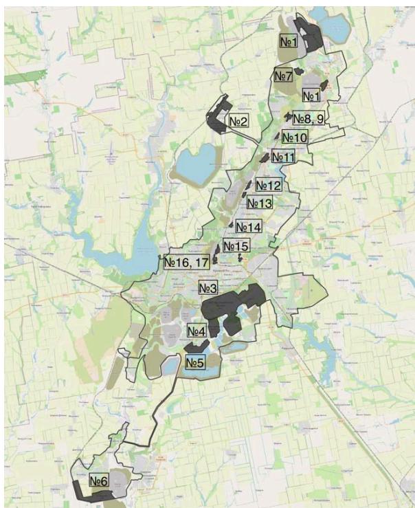
Quarries are a negative form of relief of man-made origin, within which open mining of minerals takes place. There are only 54 quarries (working and decommissioned, with re-operation) on the territory of Kryvyi Rih: 41 iron ore, 4 granite, 6 sand, 3 clay. The main condition for laying quarries is the shallow occurrence of the mineral deposit and the overlap with a small thickness of sedimentary deposits.
(See Fig. 2)
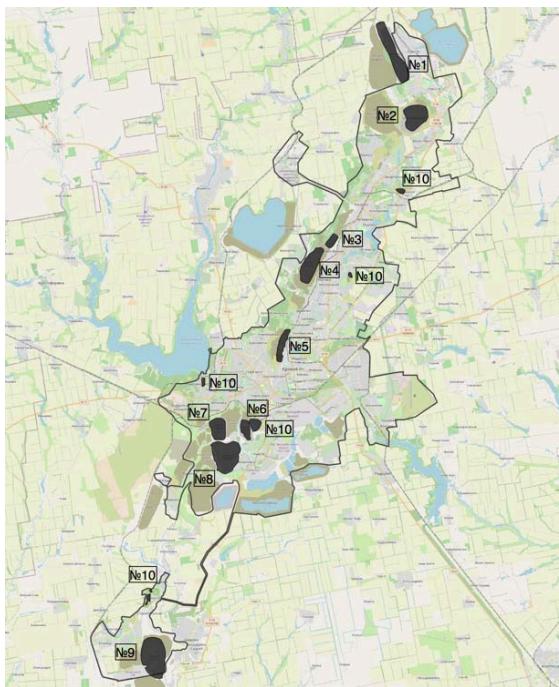
Dump mining landscapes are formed on the basis of man-made formations such as dump. Dumps are one of the main forms of anthropogenic relief, which is formed as a result of the storage of overburden on the earth's surface and the storage on the earth's surface of the by-products of mineral enrichment - slurries in the process of quarrying. Dumps are formed from "empty" and "poor" rocks that cannot be enriched. In turn, sludge occurs as a by-product of ore processing after the selection of the magnetic fraction on magnetic separators, which occurs during ore enrichment at mining and beneficiation plants. After this procedure, the sludge is pumped to sludge storage facilities where it is stored. Landfills are divided by type into sludge storage (hydraulic landfills), loose (loamy, sandy), rocky and mixed. In total, there are 104 landfills in the territory of Kryvyi Rih, ranging from low (up to 20 meters high) to very high (almost all sludge repositories with a height of 110-130 m). Landfills also vary in size from very small (up to 50 hectares) to large ones, where the area is more than 300 hectares (the area of the largest sludge storage facility of the Northern Iron Ore Enrichment Works is 1,840 hectares or 18.4 km2). (See Fig. 3)
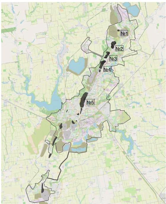
After quarries and dumps, failed landscapes represent the third group of mining anthropogenic landscapes, the emergence of which is associated with underground mining of iron ores and displacement of adjacent blocks of native rocks. There are two types of fault landscapes on the territory of Kryvyi Rih: displacement zones and fault zones (zones of the formation of troughs and depressions). There are a total of 26 such zones. (See Fig. 4)
Today, the total area of mining landscapes of Kryvyi Rih is 201 km (which can be compared with the area of the city of Lviv, which is 149 km , and the city of Odesa - 162.4 km ).
The structure of the city's mining landscapes is as follows: the area of quarries is more than ; the area of the dumps is ; sludge storage area - ; the area of mine failures and displacement zones is . The given figures are constantly changing, due to the unceasing continuation and growth of mining operations and dumping. (See Fig. 5)
- Hannivskiy quarry; 2) Pershotravneviy quarry; 3) Novokryvorizkiy Iron Ore Enrichment Works quarry; 4) Heyvatskiy quarry; 5) Southern and Northern quarries; 6) No 2 Novokryvorizkiy Iron Ore Enrichment Works quarry; 7) No 3 Novokryvorizkiy Iron Ore Enrichment Works quarry; 8) Southern Iron Ore Enrichment Works quarry; 9) Inhulets Iron Ore Enrichment Works quarry; 10) Flooded granite quarries.
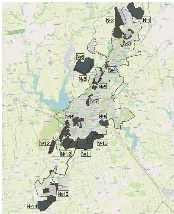 Fig. 2: Map of quarries. 1) Northern sludge storage; 2) Dump of the Hannivskiy quarry; 3) Dump of the Pershotravneviy quarry; 4) Dump of the Central Iron Ore Enrichment Works quarry; 5) Dump of the Hleyvatskiy quarry; 6) Central Iron Ore Enrichment Works sludge storage; 7) Dump of the Southern and Northern quarriques; 8) Kryvyi Rih Cement Plant sludge storage; 9) Dump of the N°2, N°3 Novokryvorizkiy Iron Ore Enrichment Works quarriques; 10) Novokryvorizkiy Iron Ore Enrichment Works sludge storage; 11) Southern Iron Ore Enrichment Works sludge storage; 12) Dump of the Southern Iron Ore Enrichment Works quarry; 13) Dump of the Inhulets Iron Ore Enrichment Works quarry; 14) Inhulets Iron Ore Enrichment Works sludge storage.
 Fig. 3: Map of industrial dumps.
1)"Pershotravneva" mine displacement zone; 2)The displacement zone of the mine named after Ordzhonikidze and the "Ternivska" mine; 3)"Gvardiyska" mine displacement zone; 4)The displacement zone of the "Yuvileina" mine and the mine named after M.V. Frunze; 5)The displacement zone of the "Saksahan" mine and the "Hihant-Hlyboka" mine.
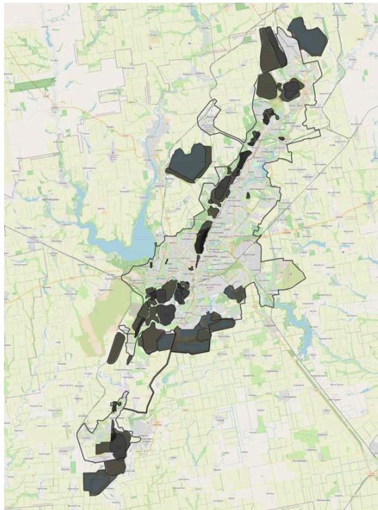 Fig. 4: Map of failed landscapes.
In order to understand the entire complex of geospatial changes of the territory of the city and the region, the issue of geographical features of Kryvyi Rih is important. The territory is located in the steppe zone and does not have large natural sources of water supply. And the development of the city's industrial complex was directly related to the creation of the necessary reserves of high-quality fresh water. This task was solved by the construction of a number of reservoirs on the existing river network and the construction of the Dnipro - Kryvyi Rih canal with a length of 41.3 km. Large-scale construction made it possible to ensure the supply of huge volumes of water for the needs of industry and the city's population.
Water supply to the city and the Kryvyi Rih region is carried out from two main sources: the Karachuniv reservoir and the Southern reservoir. There are a total of 5 reservoirs near the city, which perform different functions:
-
The Karachuniv reservoir (area reaches over 36 km ) on the Inhulets river (the largest and oldest - 90 years) is used as a source of water intake, a recreation area, for fish farming, land irrigation and flood water level regulation. It was laid in 1930 in connection with the construction of the Kryvyi Rih Metallurgical Plant (now ArcelorMittal Kryvyi Rih).
-
The southern reservoir was artificially created in the Taranova and Chebanka streams (the basin of the Kamianka river). It was built in 1961 to store Dnipro water, which is supplied to it by the Dnipro-Kryvyi Rih canal and is intended for drinking and domestic purposes, irrigation of agricultural land.
-
The Iskriv reservoir was built in 1958. Length 35 km, width up to 1.7 km. The reservoir was built for the technical water supply of the Kryvyi Rih basin and the city of Yellow Waters, as well as for irrigation.
-
The Kresiv reservoir was created on the Saksahan river at the beginning of the 20th century for a hydroelectric power plant. Water can be used only for technical purposes.
-
Makortov reservoir on the Saksahan river 25 km from the town of Zhovti Vody, created in 1958. The reservoir is the first of the cascades of Saksahan reservoirs and accumulates Saksahan river runoff.
The water is used for industrial water supply of the Kryvyi Rih iron ore basin, irrigation of agricultural lands. [5]. (See Fig. 6)
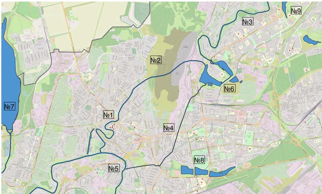 Fig. 5: Map of mining landscapes.
- The old channel of the Saksahan river; 2) Path of the Saksahan river before the construction of the South and North quarries; 3) Saksahan river; 4) Saksahansky derivation tunnel; 5) Inhulets river; 6) Saksahan reservoir; 7) Karachuniv reservoir; 8) "ArcelorMittal Kryvyi Rih" settling ponds; 9) Ponds of "Sonyachny" and "Hirnytskyi" microdistricts.
[Fig. 6]
The Saksahansky derivation tunnel was built in 1957, simultaneously with the Saksahansky reservoir. The construction of the tunnel was due to the availability of rich iron ores in the Saksahan river valley, after the diversion of the river, iron ore mining began in the newly established "Pivdenniy" quarry, located in the mine field of the mine Kirova.
The tunnel, 5.3 km long, at depths from the day surface of 24-65 m, from the Saksahan reservoir to the exit portal on the Inhulets river. The exit portal, i.e. the present-day mouth of the Saksahan river, is located 1.5 km downstream of the Inhulets river than the historical mouth.
Unfortunately, the industrial development of the region, in addition to economic and social benefits and geospatial changes of the territory, led to serious environmental consequences. Kryvyi Rih is one of the most ecologically dangerous cities in Ukraine. Mining and processing enterprises, to which the city owes its development, are also its biggest problem. The volume of products produced at the enterprises of the complex reaches 33% of the total volume of production in Ukraine, and emissions of pollutants into the air by the enterprises of the complex, according to unofficial data, annually amount to more than 1.5 million tons, or almost 32% of the total emissions in the country. From these data, it becomes clear what an extraordinary environmental load the 600,000-strong population of the industrial city and the environment receives.
Atmospheric air experiences the greatest negative impact from the activities of enterprises in Kryvyi Rih. The main pollutants are carbon monoxide (73%), dust (15%), sulfur dioxide (3%) and other harmful substances (hydrogen sulfide, ammonia, phenol, formaldehyde and others). Although official statistics emphasize the annual reduction of emissions into the atmosphere and the improvement of cleaning technologies at the enterprises of the region, in reality, public activists and independent environmentalists record repeated unauthorized emissions of harmful substances into the atmosphere and significantly higher emission rates. [8] In July 2019, the government created the "Office of Control of Emissions into the Atmosphere" in Kryvyi Rih. The main task of this inspection is to control emissions of polluting enterprises. After all, the network of control points is located in the system of the enterprises themselves, so the real state of emissions and even the access of independent ecologists to the enterprises is extremely complicated.
The low level of efficiency in the use of subsoil and raw materials with significant volumes of its extraction led to large losses of minerals in the subsoil and the accumulation of a large amount of production waste in the form of dumps and sludges.
One of the problems is soil pollution as a result of the activities of industrial enterprises. Polluting substances enter the atmospheric air, and then settle on the ground and are washed away by precipitation within a radius of up to 5 km from a stationary source of emissions.
One of the objects of the environment, the most important for humans and at the same time the most susceptible to the influence of heavy metals, is natural water. Their contamination with heavy metals occurs due to the discharge of insufficiently purified water by enterprises of the mining, metallurgical and metalworking industries directly into the rivers of the region. Approximately half of city wastewater is discharged into water bodies insufficiently treated, of which about 15% - without treatment at all. Up to 70% of industrial wastewater is discharged without any treatment.
The Inhulets river should be noted among the most polluted rivers. The Saksahan river also suffered an irreversible negative impact. The natural regime of the river has been greatly changed by the regulatory influence of dams, the discharge of mine and industrial waters, as well as the withdrawal of water for technical needs. Also, the transfer of a large section of the river into a derivation channel led to waterlogging of the old part of the channel. Attempts to artificially feed the old channel with a pipeline from the Karachuniv reservoir did not give the desired result. Therefore, a large section of the river on the territory of the city is actually gradually becoming swampy.
A significant concentration of potentially dangerous objects on the territory of the city (mines, quarries, landfills, sludge storage facilities, spent voids, etc.), which, if groundwater pumping is stopped or reservoirs overflow, will inevitably become a source of emergency situations and man-made disasters. The lack of a real alternative to the full use or disposal of excess return water dictates the need for annual measures to discharge excess return water from Kryvyi Rih mining and ore enterprises.
The disposal of industrial and household waste is a big problem in the cities of Ukraine. The complexity of the problem is proportional to the population and industrial potential of the city. In metallurgy and thermal energy, up to 40% of the enterprise's territory is used for waste storage. As a result, unique anthropogenic landscapes are formed in close proximity to human habitation. They are due to the presence of waste from the mining industry, which is presented in the form of dumps, sludge storages, terricones and landfills, which form zones of man-made desertification, the area of which by the end of the 20th century. was about 8% of the total territory of Ukraine. Even according to official statistics, emissions of harmful substances amount to more than 395,000 tons - 590 kg per person. But independent experts talk about exceeding these data several times. Also, almost 9 billion tons of industrial waste have accumulated at the enterprises of the region, which causes the clogging of huge areas of fertile land.
In the process of production activities of Kryvyi Rih enterprises, more than 169 million m3 of industrial waste is generated annually, which is taken to landfills and sludge storage facilities, where more than 2.5 billion m3 of enrichment waste is already stored; they cover an area of about 16,000 hectares. This means that huge areas of fertile land are lost forever, and the area of these objects will increase every year. It should be noted that these objects also have a negative impact on the environment, as they pollute huge areas of agricultural land and residential areas. [8]
The main polluting enterprises are located in the immediate vicinity of residential areas, since historically urban residential buildings were formed for the needs of each enterprise.
Mining of ore in the subsoil, pumping of underground water, a huge amount of artificial sediments created by man - cause changes in the geological structure, which cause an increase in the man-made crisis.
The city's environmental program provides for industrial enterprises to modernize existing production facilities and dust and gas treatment plants, build new efficient dust and gas collection systems, as well as a set of dust suppression measures at landfills, sludge storage facilities, product warehouses, industrial sites, highways, streets of residential areas in the area of industrial activity including the use of binders, as well as cooperation with specialized scientific organizations on the development, review and implementation of new technologies for dust suppression, including "green technologies". But all the measures envisaged by the program require constant state control. [1].
The city experienced rapid economic development in the 20th century. from a town of 20,000 people, it grew into a large city, which at the beginning of independence reached almost a million people. Industrial development became the impetus for the development of residential construction and the unification of many towns of Kryvyi Rih agglomeration into a large city, which is the longest in Ukraine and Europe.
During the Soviet era, all giant enterprises such as "ArcelorMittal Kryvyi Rih" and 5 Iron Ore Enrichment Works emerged, which became the largest mining and metallurgical enterprises of Ukraine. This led to the development of railways, road and air routes.
What became a decisive factor for the rapid development of the city. Today, Kryvyi Rih is the "metallurgical capital of Ukraine", one of the largest cities and has great prospects for development and improvement of the standard of living. The city has one of the lowest unemployment rates.
But at the same time, the city's enterprises are among the biggest air polluters in Ukraine, which have a negative impact on the air, rivers and fertile soils of the region. Due to the unsatisfactory condition of the components of the natural environment, the incidence of lung diseases and cancer in Kryvyi Rih residents is very high.
The industrial landscapes formed as a result of iron ore mining and processing carry a potential man-made danger and require a constant search for solutions for their reclamation, conservation and disposal of production waste.
Although dust and gas capture systems have been used in recent decades, and the rates of extraction and processing have decreased, thereby reducing the impact on the environment, the ecological situation in the city is very complex and requires constant monitoring by state environmental inspections and the public.
Conflict of Interest
The authors declare no conflict of interest.
Ethical Approval
Not applicable
Data Availability
The datasets used in this study are openly available at [repository link] and the source code is available on GitHub at [GitHub link].
Funding
This work did not receive any external funding.
References
Cite this article
Related Research


Special Issue
Launch a focused special issue to highlight research, emerging trends, and expert insights in your academic field.
